Property Record
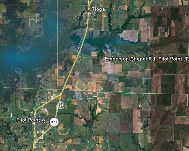
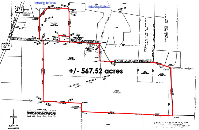
Emerson Chapel Rd, Pilot Point, TX 76258
Property Detail
Emerson Chapel Rd
Sherman-Denison, TX
G-0960 PORTMAN CLAYTON A-G0960, ACRES 241.652
135050
GRAYSON
Agriculturalland
Texas
B and X Area of moderate flood hazard, usually the area between the limits of the 100-year and 500-year floods.
30.30 AC
2024
Pilot Point
2025
Other Market Areas
020129
NEARBY LISTINGS FOR SALE OR LEASE
DEMOGRAPHICS near Emerson Chapel Rd
1 mile
3 mile
5 mile
2024 Total Population
58
2,762
9,163
2029 Population
63
3,081
10,407
Pop Growth 2024-2029
+ 8.62%
+ 11.55%
+ 13.58%
Average Age
40
39
40
2024 Total Households
21
995
3,235
HH Growth 2024-2029
+ 9.52%
+ 11.46%
+ 13.54%
Median Household Inc
$71,249
$92,679
$100,548
Avg Household Size
2.70
2.80
2.80
2024 Avg HH Vehicles
2.00
2.00
2.00
Median Home Value
$350,000
$354,744
$378,659
Median Year Built
1997
2000
2001
Nearby Places
Map Layers
Map Styles
 Street
 Aerial
Transit
 Traffic
 Biking
Places
Listings with unknown addresses are not visible on the map
- Restaurants
- Banks
- Shops
- Fitness
- Groceries
SALE & LEASE HISTORY
LISTING DATE
SALE/LEASE

Apr 20, 2021
For Sale
Nearby Properties
Address
Land Use
TOTAL SIZE
Lot Size
Zoning
Address
Land Use
TOTAL SIZE
Lot Size
Zoning
210,260 SF
17.39 AC
Address
Land Use
TOTAL SIZE
Lot Size
Zoning
83,280 SF
8.08 AC
Address
Land Use
TOTAL SIZE
Lot Size
Zoning
19,558 SF
2.53 AC
Address
Land Use
TOTAL SIZE
Lot Size
Zoning
51,500 SF
10 AC
Address
Land Use
TOTAL SIZE
Lot Size
Zoning
1,962 SF
8 AC
Address
Land Use
TOTAL SIZE
Lot Size
Zoning
8,640 SF
16.40 AC
Address
Land Use
TOTAL SIZE
Lot Size
Zoning
1,200 SF
15 AC
Address
Land Use
TOTAL SIZE
Lot Size
Zoning
41,862 SF
3.25 AC
Address
Land Use
TOTAL SIZE
Lot Size
Zoning
20,725 SF
1.86 AC
Address
Land Use
TOTAL SIZE
Lot Size
Zoning
8,146 SF
4.75 AC
Address
Land Use
TOTAL SIZE
Lot Size
Zoning
9,400 SF
0.98 AC
Address
Land Use
TOTAL SIZE
Lot Size
Zoning
23,276 SF
0.93 AC
12A
Address
Land Use
TOTAL SIZE
Lot Size
Zoning
23,808 SF
1.88 AC
Address
Land Use
TOTAL SIZE
Lot Size
Zoning
25,665 SF
0.64 AC
Address
Land Use
TOTAL SIZE
Lot Size
Zoning
6,249 SF
11.93 AC
Address
Land Use
TOTAL SIZE
Lot Size
Zoning
5,484 SF
12.61 AC
Address
Land Use
TOTAL SIZE
Lot Size
Zoning
6,177 SF
2.67 AC
Address
Land Use
TOTAL SIZE
Lot Size
Zoning
138.03 AC
Address
Land Use
TOTAL SIZE
Lot Size
Zoning
9,504 SF
1.21 AC
Address
Land Use
TOTAL SIZE
Lot Size
Zoning
5,810 SF
13.45 AC
Address
Land Use
TOTAL SIZE
Lot Size
Zoning
8.80 AC
Address
Land Use
TOTAL SIZE
Lot Size
Zoning
17,250 SF
0.61 AC
Address
Land Use
TOTAL SIZE
Lot Size
Zoning
9,230 SF
1.17 AC
Address
Land Use
TOTAL SIZE
Lot Size
Zoning
480 SF
28.26 AC
Address
Land Use
TOTAL SIZE
Lot Size
Zoning
20,700 SF
1.48 AC
Address
Land Use
TOTAL SIZE
Lot Size
Zoning
4,845 SF
35 AC
Address
Land Use
TOTAL SIZE
Lot Size
Zoning
3,279 SF
6.62 AC
Address
Land Use
TOTAL SIZE
Lot Size
Zoning
7.69 AC
Address
Land Use
TOTAL SIZE
Lot Size
Zoning
14,700 SF
0.61 AC
Address
Land Use
TOTAL SIZE
Lot Size
Zoning
11,940 SF
4.72 AC
The World's #1 Commercial Real Estate Marketplace
Connect with us
© 2026 CoStar Group
The information above has been obtained from sources believed reliable. While we do not doubt its accuracy we have not verified it and make no guarantee, warranty or representation about it. It is your responsibility to independently confirm its accuracy and completeness. Any projections, opinions, assumptions, or estimates used are for example only and do not represent the current or future performance of the property. The value of this transaction to you depends on tax and other factors which should be evaluated by your tax, financial, and legal advisors. You and your advisors should conduct a careful, independent investigation of the property to determine to your satisfaction the suitability of the property for your needs.