Property Record
Emory Crossing Rd, Clarksville, IN 47129
NEARBY LISTINGS FOR SALE OR LEASE
Property Detail
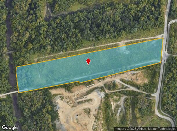
Emory Crossing Rd
Louisville-Jefferson County, KY-IN
Town Clarksville
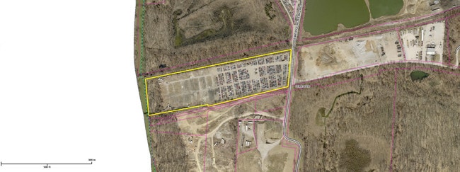
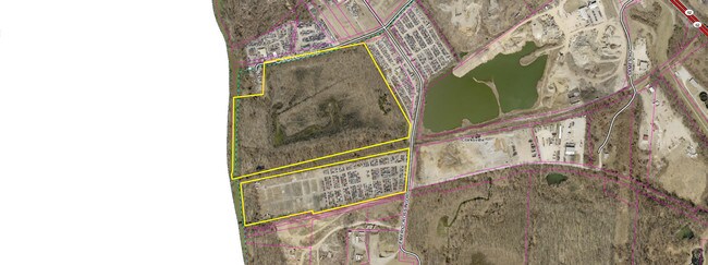
10-24-00-100-050.000-013
OUTLOT 49 7.26 AC CLARKSVILLE TIF (53)
Institutionalgeneral
Clark
AE
Indiana
21111C0012F
49
0
7.26 AC
2024
South Clark County
050403
Louisville
DEMOGRAPHICS near Emory Crossing Rd
1 Mile
3 Mile
5 Mile
2024 Total Population
5,300
78,303
202,478
2029 Population
5,495
81,024
207,977
Pop Growth 2024-2029
+ 3.68%
+ 3.47%
+ 2.72%
Average Age
39
40
39
2024 Total Households
2,204
33,364
88,177
HH Growth 2024-2029
+ 3.49%
+ 3.64%
+ 2.76%
Median Household Inc
$51,134
$42,027
$42,170
Avg Household Size
2.30
2.20
2.20
2024 Avg HH Vehicles
2.00
1.00
1.00
Median Home Value
$140,312
$130,903
$147,833
Median Year Built
1948
1959
1961
Nearby Places
Map Layers
Map Styles
 Street
 Aerial
- Restaurants
- Banks
- Shops
- Fitness
- Groceries
PUBLIC TRANSPORTATION
AIRPORT
Louisville Muhammad Ali International
DRIVE
WALK
Distance
Louisville Muhammad Ali International
23 min
12.3 mi
Freight Ports
Port of Toledo
DRIVE
WALK
Distance
Port of Toledo
359 min
308.4 mi
SALE & LEASE HISTORY
LISTING DATE
SALE/LEASE

Sep 24, 2016
For Sale
Nearby Properties
Address
Land Use
TOTAL SIZE
Lot Size
Zoning
Address
Land Use
TOTAL SIZE
Lot Size
Zoning
2.97 AC
C3-CENTRAL
Address
Land Use
TOTAL SIZE
Lot Size
Zoning
2.07 AC
Address
Land Use
TOTAL SIZE
Lot Size
Zoning
3,452 SF
13.22 AC
Address
Land Use
TOTAL SIZE
Lot Size
Zoning
4.58 AC
C3-CENTRAL
Address
Land Use
TOTAL SIZE
Lot Size
Zoning
109,470 SF
2.27 AC
Address
Land Use
TOTAL SIZE
Lot Size
Zoning
119,395 SF
0.54 AC
C3-CENTRAL
Address
Land Use
TOTAL SIZE
Lot Size
Zoning
95,508 SF
3.67 AC
EZ1-ENTERP
Address
Land Use
TOTAL SIZE
Lot Size
Zoning
120,337 SF
18.20 AC
Address
Land Use
TOTAL SIZE
Lot Size
Zoning
16,221 SF
2.40 AC
Address
Land Use
TOTAL SIZE
Lot Size
Zoning
303,047 SF
7.21 AC
Address
Land Use
TOTAL SIZE
Lot Size
Zoning
2,208 SF
26.20 AC
Address
Land Use
TOTAL SIZE
Lot Size
Zoning
2,000 SF
13.11 AC
Address
Land Use
TOTAL SIZE
Lot Size
Zoning
136,949 SF
36.89 AC
Address
Land Use
TOTAL SIZE
Lot Size
Zoning
12,270 SF
13.50 AC
Address
Land Use
TOTAL SIZE
Lot Size
Zoning
25,728 SF
10.37 AC
Address
Land Use
TOTAL SIZE
Lot Size
Zoning
56,775 SF
5.30 AC
Address
Land Use
TOTAL SIZE
Lot Size
Zoning
12,752 SF
13.56 AC
Address
Land Use
TOTAL SIZE
Lot Size
Zoning
79,558 SF
0.48 AC
C3-CENTRAL
Address
Land Use
TOTAL SIZE
Lot Size
Zoning
1,276 SF
3.78 AC
Address
Land Use
TOTAL SIZE
Lot Size
Zoning
75,560 SF
8.18 AC
Address
Land Use
TOTAL SIZE
Lot Size
Zoning
9,900 SF
11.23 AC
Address
Land Use
TOTAL SIZE
Lot Size
Zoning
16,920 SF
0.18 AC
C3-CENTRAL
Address
Land Use
TOTAL SIZE
Lot Size
Zoning
3,692 SF
15.99 AC
Address
Land Use
TOTAL SIZE
Lot Size
Zoning
204,428 SF
9.82 AC
Address
Land Use
TOTAL SIZE
Lot Size
Zoning
143,700 SF
0.29 AC
Address
Land Use
TOTAL SIZE
Lot Size
Zoning
86,719 SF
7.04 AC
Address
Land Use
TOTAL SIZE
Lot Size
Zoning
135,020 SF
2.02 AC
Address
Land Use
TOTAL SIZE
Lot Size
Zoning
32,850 SF
9.21 AC
Address
Land Use
TOTAL SIZE
Lot Size
Zoning
17,920 SF
0.98 AC
C2-COMMERC
Address
Land Use
TOTAL SIZE
Lot Size
Zoning
141,370 SF
0.72 AC
The World's #1 Commercial Real Estate Marketplace
Connect with us
© 2025 CoStar Group
The information above has been obtained from sources believed reliable. While we do not doubt its accuracy we have not verified it and make no guarantee, warranty or representation about it. It is your responsibility to independently confirm its accuracy and completeness. Any projections, opinions, assumptions, or estimates used are for example only and do not represent the current or future performance of the property. The value of this transaction to you depends on tax and other factors which should be evaluated by your tax, financial, and legal advisors. You and your advisors should conduct a careful, independent investigation of the property to determine to your satisfaction the suitability of the property for your needs.