Property Record
Evans Rd, Rosenberg, TX 77471

Property Detail
Evans Rd
Houston-Pasadena-The Woodlands, TX
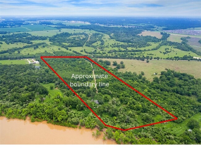
0026 JNO FOSTER HALF LEAGUE, TRACT 7, ACRES 36.664
0026-00-000-0071-901
FORT BEND
Commercialnec
Texas
W
7
AE The base floodplain where base flood elevations are provided. AE Zones are now used on new format FIRMs instead of A1-A30 Zones.
36.66 AC
2024
Southwest Outlier
2025
Houston
675300
NEARBY LISTINGS FOR SALE OR LEASE
DEMOGRAPHICS near Evans Rd
1 mile
3 mile
5 mile
2025 Total Population
22
11,602
63,080
2030 Population
25
13,320
71,798
Pop Growth 2025-2030
+ 13.64%
+ 14.81%
+ 13.82%
Average Age
38
37
38
2025 Total Households
7
3,708
20,972
HH Growth 2025-2030
+ 14.29%
+ 15.21%
+ 14.25%
Median Household Inc
$225,000
$85,416
$74,393
Avg Household Size
2.90
3.10
2.90
2025 Avg HH Vehicles
3.00
2.00
2.00
Median Home Value
$750,000
$311,076
$273,268
Median Year Built
2010
1999
1992
Nearby Places
Map Layers
Map Styles
 Street
 Aerial
Transit
 Traffic
 Biking
Places
Listings with unknown addresses are not visible on the map
- Restaurants
- Banks
- Shops
- Fitness
- Groceries
SALE & LEASE HISTORY
LISTING DATE
SALE/LEASE

Mar 21, 2025
For Sale
Nearby Properties
Address
Land Use
TOTAL SIZE
Lot Size
Zoning
Address
Land Use
TOTAL SIZE
Lot Size
Zoning
116.02 AC
YST
Address
Land Use
TOTAL SIZE
Lot Size
Zoning
672,112 SF
81.77 AC
YHN
Address
Land Use
TOTAL SIZE
Lot Size
Zoning
438,371 SF
132.75 AC
Address
Land Use
TOTAL SIZE
Lot Size
Zoning
54.25 AC
L
Address
Land Use
TOTAL SIZE
Lot Size
Zoning
21,218 SF
1.86 AC
Address
Land Use
TOTAL SIZE
Lot Size
Zoning
220,453 SF
142.24 AC
SQ
Address
Land Use
TOTAL SIZE
Lot Size
Zoning
4.73 AC
Address
Land Use
TOTAL SIZE
Lot Size
Zoning
124,548 SF
13.72 AC
S
Address
Land Use
TOTAL SIZE
Lot Size
Zoning
21,110 SF
4 AC
S
Address
Land Use
TOTAL SIZE
Lot Size
Zoning
79,635 SF
12.08 AC
Address
Land Use
TOTAL SIZE
Lot Size
Zoning
44,000 SF
1.79 AC
Address
Land Use
TOTAL SIZE
Lot Size
Zoning
40,260 SF
10.82 AC
S
Address
Land Use
TOTAL SIZE
Lot Size
Zoning
137.92 AC
Address
Land Use
TOTAL SIZE
Lot Size
Zoning
0.86 AC
Address
Land Use
TOTAL SIZE
Lot Size
Zoning
31,742 SF
9.19 AC
Address
Land Use
TOTAL SIZE
Lot Size
Zoning
119.69 AC
QHY
Address
Land Use
TOTAL SIZE
Lot Size
Zoning
175.10 AC
Address
Land Use
TOTAL SIZE
Lot Size
Zoning
67.93 AC
Address
Land Use
TOTAL SIZE
Lot Size
Zoning
139,047 SF
49.85 AC
Address
Land Use
TOTAL SIZE
Lot Size
Zoning
120,196 SF
17.85 AC
S
Address
Land Use
TOTAL SIZE
Lot Size
Zoning
12,276 SF
1.55 AC
Address
Land Use
TOTAL SIZE
Lot Size
Zoning
Address
Land Use
TOTAL SIZE
Lot Size
Zoning
21,050 SF
5.07 AC
ST
Address
Land Use
TOTAL SIZE
Lot Size
Zoning
50,576 SF
2.23 AC
Address
Land Use
TOTAL SIZE
Lot Size
Zoning
24.71 AC
XY
Address
Land Use
TOTAL SIZE
Lot Size
Zoning
3.13 AC
Address
Land Use
TOTAL SIZE
Lot Size
Zoning
1,196 SF
46.56 AC
QR
Address
Land Use
TOTAL SIZE
Lot Size
Zoning
7,528 SF
1.51 AC
Address
Land Use
TOTAL SIZE
Lot Size
Zoning
29,120 SF
5.96 AC
S,Y
Address
Land Use
TOTAL SIZE
Lot Size
Zoning
1.47 AC
L
The World's #1 Commercial Real Estate Marketplace
Connect with us
© 2026 CoStar Group
The information above has been obtained from sources believed reliable. While we do not doubt its accuracy we have not verified it and make no guarantee, warranty or representation about it. It is your responsibility to independently confirm its accuracy and completeness. Any projections, opinions, assumptions, or estimates used are for example only and do not represent the current or future performance of the property. The value of this transaction to you depends on tax and other factors which should be evaluated by your tax, financial, and legal advisors. You and your advisors should conduct a careful, independent investigation of the property to determine to your satisfaction the suitability of the property for your needs.