Property Record
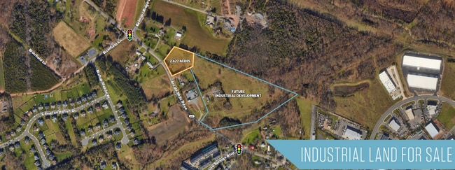
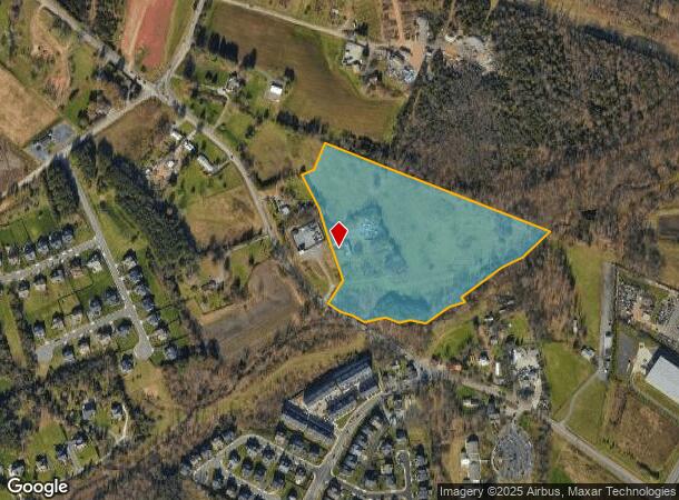
24604 Arcola Mills Dr, Ashburn, VA 20148
This Property Is For Sale
NEARBY LISTINGS FOR SALE OR LEASE
Property Detail
24604 Arcola Mills Dr
161-15-4340
Arcola
Commercialnec
ARCOLA 202402220006639/40P BLA, 200304040039073 1982--1626, 799--232, 116--485 WB, 683-632
AE
Loudoun
51107C0360E
Virginia
2025
16.87 AC
2025
Route 28 Corridor North
611812
Washington, DC
1,210 SF
Washington-Arlington-Alexandria, DC-VA-MD-WV
DEMOGRAPHICS near 24604 Arcola Mills Dr
1 Mile
3 Mile
5 Mile
2024 Total Population
7,508
77,201
149,461
2029 Population
8,342
84,034
162,077
Pop Growth 2024-2029
+ 11.11%
+ 8.85%
+ 8.44%
Average Age
33
34
35
2024 Total Households
2,277
23,538
45,807
HH Growth 2024-2029
+ 11.24%
+ 8.92%
+ 8.62%
Median Household Inc
$206,785
$189,907
$182,738
Avg Household Size
3.30
3.30
3.20
2024 Avg HH Vehicles
2.00
2.00
2.00
Median Home Value
$775,873
$732,480
$732,547
Median Year Built
2011
2010
2010
Nearby Places
Map Layers
Map Styles
 Street
 Aerial
- Restaurants
- Banks
- Shops
- Fitness
- Groceries
PUBLIC TRANSPORTATION
AIRPORT
Washington Dulles International
DRIVE
WALK
Distance
Washington Dulles International
21 min
10.1 mi
Ronald Reagan Washington Ntl
DRIVE
WALK
Distance
Ronald Reagan Washington Ntl
51 min
33.7 mi
Freight Ports
Port of Baltimore
DRIVE
WALK
Distance
Port of Baltimore
94 min
67.9 mi
Nearby Properties
Address
Land Use
TOTAL SIZE
Lot Size
Zoning
Address
Land Use
TOTAL SIZE
Lot Size
Zoning
525,482 SF
39.73 AC
PDGI
Address
Land Use
TOTAL SIZE
Lot Size
Zoning
669,358 SF
39.88 AC
IP
Address
Land Use
TOTAL SIZE
Lot Size
Zoning
538,565 SF
135.31 AC
PDIP
Address
Land Use
TOTAL SIZE
Lot Size
Zoning
784,204 SF
128.54 AC
GI
Address
Land Use
TOTAL SIZE
Lot Size
Zoning
695,321 SF
63.54 AC
PDGI
Address
Land Use
TOTAL SIZE
Lot Size
Zoning
204,014 SF
23.47 AC
PDIP
Address
Land Use
TOTAL SIZE
Lot Size
Zoning
252,600 SF
33.26 AC
PDIP
Address
Land Use
TOTAL SIZE
Lot Size
Zoning
759,405 SF
64.76 AC
IP
Address
Land Use
TOTAL SIZE
Lot Size
Zoning
767,464 SF
GI
Address
Land Use
TOTAL SIZE
Lot Size
Zoning
49.36 AC
IP
Address
Land Use
TOTAL SIZE
Lot Size
Zoning
415,477 SF
97.76 AC
TR1UBF
Address
Land Use
TOTAL SIZE
Lot Size
Zoning
222,313 SF
36.21 AC
PDOP
Address
Land Use
TOTAL SIZE
Lot Size
Zoning
378,278 SF
112.87 AC
PDGI
Address
Land Use
TOTAL SIZE
Lot Size
Zoning
422,597 SF
85.43 AC
TR3UBF
Address
Land Use
TOTAL SIZE
Lot Size
Zoning
327,400 SF
37.53 AC
PDGI
Address
Land Use
TOTAL SIZE
Lot Size
Zoning
48.30 AC
PDIP
Address
Land Use
TOTAL SIZE
Lot Size
Zoning
59.20 AC
IP
Address
Land Use
TOTAL SIZE
Lot Size
Zoning
181,718 SF
10.23 AC
R16
Address
Land Use
TOTAL SIZE
Lot Size
Zoning
303,168 SF
41.95 AC
PDCCRC
Address
Land Use
TOTAL SIZE
Lot Size
Zoning
259,361 SF
65.01 AC
PDH4
Address
Land Use
TOTAL SIZE
Lot Size
Zoning
264,902 SF
60.25 AC
PDH4
Address
Land Use
TOTAL SIZE
Lot Size
Zoning
54 AC
PDTC
Address
Land Use
TOTAL SIZE
Lot Size
Zoning
39.89 AC
PDGI
Address
Land Use
TOTAL SIZE
Lot Size
Zoning
128,948 SF
11.16 AC
PDH4
Address
Land Use
TOTAL SIZE
Lot Size
Zoning
126,263 SF
9.09 AC
PDH4
Address
Land Use
TOTAL SIZE
Lot Size
Zoning
1,848 SF
21.23 AC
PDIP
Address
Land Use
TOTAL SIZE
Lot Size
Zoning
107,378 SF
16.86 AC
PDH4
Address
Land Use
TOTAL SIZE
Lot Size
Zoning
169,872 SF
33.51 AC
PDH4
The World's #1 Commercial Real Estate Marketplace
Connect with us
© 2025 CoStar Group
The information above has been obtained from sources believed reliable. While we do not doubt its accuracy we have not verified it and make no guarantee, warranty or representation about it. It is your responsibility to independently confirm its accuracy and completeness. Any projections, opinions, assumptions, or estimates used are for example only and do not represent the current or future performance of the property. The value of this transaction to you depends on tax and other factors which should be evaluated by your tax, financial, and legal advisors. You and your advisors should conduct a careful, independent investigation of the property to determine to your satisfaction the suitability of the property for your needs.