Property Record
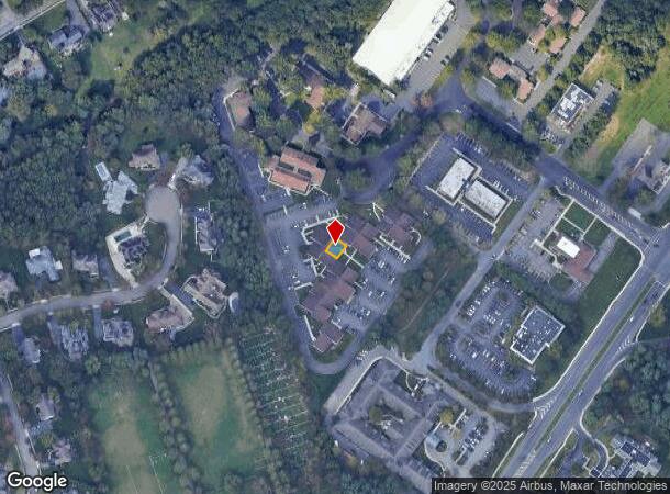
10 Barrie Rd E, East Brunswick, NJ 08816
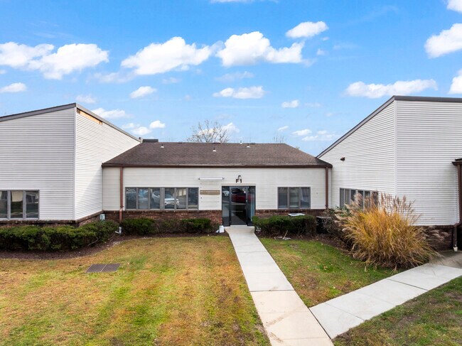
This Property Is For Sale
NEARBY LISTINGS FOR SALE OR LEASE
-
-
-
-
-
-
-
-
No Photo
-
-
View all East Brunswick listings for sale on LoopNet.com
Property Detail
10 Barrie Rd E
New York-Jersey City-White Plains, NY-NJ
Cornwall Court Bldg #G
04-00319-0000-00036-0000-C0012
0.1780
Officebuilding
Middlesex
X
New Jersey
34023C0141F
36
2024
0.18 AC
2025
Brunswick
006500
Northern New Jersey
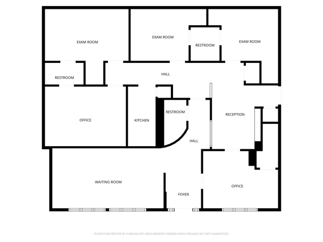
1,646 SF
DEMOGRAPHICS near 10 Barrie Rd E
1 Mile
3 Mile
5 Mile
2024 Total Population
11,530
64,174
177,166
2029 Population
11,996
66,872
184,815
Pop Growth 2024-2029
+ 4.04%
+ 4.20%
+ 4.32%
Average Age
43
42
41
2024 Total Households
4,265
22,550
60,904
HH Growth 2024-2029
+ 4.13%
+ 4.27%
+ 4.45%
Median Household Inc
$132,958
$135,279
$120,010
Avg Household Size
2.70
2.80
2.80
2024 Avg HH Vehicles
2.00
2.00
2.00
Median Home Value
$635,970
$524,425
$494,490
Median Year Built
1981
1969
1973
Nearby Places
- Restaurants
- Banks
- Shops
- Fitness
- Groceries
PUBLIC TRANSPORTATION
COMMUTER RAIL
New Brunswick (Northeast Corridor Line - NJ Transit Commuter Rail (NJ Transit))
DRIVE
WALK
Distance
New Brunswick (Northeast Corridor Line - NJ Transit Commuter Rail (NJ Transit))
17 min
7.9 mi
Jersey Avenue (Northeast Corridor Line - NJ Transit Commuter Rail (NJ Transit))
DRIVE
WALK
Distance
Jersey Avenue (Northeast Corridor Line - NJ Transit Commuter Rail (NJ Transit))
23 min
8.2 mi
AIRPORT
Trenton Mercer
DRIVE
WALK
Distance
Trenton Mercer
48 min
27.9 mi
Newark Liberty International
DRIVE
WALK
Distance
Newark Liberty International
45 min
30.9 mi
Freight Ports
New York Container Terminal
DRIVE
WALK
Distance
New York Container Terminal
39 min
25.9 mi
Nearby Properties
Address
Land Use
TOTAL SIZE
Lot Size
Zoning
Address
Land Use
TOTAL SIZE
Lot Size
Zoning
Address
Land Use
TOTAL SIZE
Lot Size
Zoning
87.65 AC
LI-4
Address
Land Use
TOTAL SIZE
Lot Size
Zoning
160,986 SF
60.24 AC
Address
Land Use
TOTAL SIZE
Lot Size
Zoning
5.10 AC
Address
Land Use
TOTAL SIZE
Lot Size
Zoning
56 AC
LI-4
Address
Land Use
TOTAL SIZE
Lot Size
Zoning
245,980 SF
54.02 AC
OP1
Address
Land Use
TOTAL SIZE
Lot Size
Zoning
48.39 AC
LI-4
Address
Land Use
TOTAL SIZE
Lot Size
Zoning
8,512 SF
65.36 AC
MH
Address
Land Use
TOTAL SIZE
Lot Size
Zoning
413,092 SF
35.48 AC
LI-4
Address
Land Use
TOTAL SIZE
Lot Size
Zoning
34.73 AC
LI-4
Address
Land Use
TOTAL SIZE
Lot Size
Zoning
526,400 SF
40 AC
LI-4
Address
Land Use
TOTAL SIZE
Lot Size
Zoning
320,852 SF
39 AC
LI4R
Address
Land Use
TOTAL SIZE
Lot Size
Zoning
26.69 AC
LI-4
Address
Land Use
TOTAL SIZE
Lot Size
Zoning
2.53 AC
HR
Address
Land Use
TOTAL SIZE
Lot Size
Zoning
93,180 SF
0.65 AC
C-4
Address
Land Use
TOTAL SIZE
Lot Size
Zoning
418,300 SF
27.40 AC
LI-4
Address
Land Use
TOTAL SIZE
Lot Size
Zoning
34.64 AC
LI-4
Address
Land Use
TOTAL SIZE
Lot Size
Zoning
368.92 AC
RP
Address
Land Use
TOTAL SIZE
Lot Size
Zoning
29.98 AC
O1
Address
Land Use
TOTAL SIZE
Lot Size
Zoning
64,544 SF
7.62 AC
C-2
Address
Land Use
TOTAL SIZE
Lot Size
Zoning
282,731 SF
24.96 AC
HC2
Address
Land Use
TOTAL SIZE
Lot Size
Zoning
13.01 AC
HC3
Address
Land Use
TOTAL SIZE
Lot Size
Zoning
62.23 AC
R2
Address
Land Use
TOTAL SIZE
Lot Size
Zoning
8.95 AC
R100
Address
Land Use
TOTAL SIZE
Lot Size
Zoning
293,800 SF
23.81 AC
LI-4
Address
Land Use
TOTAL SIZE
Lot Size
Zoning
57,900 SF
8.96 AC
B-5
Address
Land Use
TOTAL SIZE
Lot Size
Zoning
19,110 SF
0.29 AC
C-3B
Address
Land Use
TOTAL SIZE
Lot Size
Zoning
11.79 AC
VG3
Address
Land Use
TOTAL SIZE
Lot Size
Zoning
Address
Land Use
TOTAL SIZE
Lot Size
Zoning
179,144 SF
24.40 AC
LI
The World's #1 Commercial Real Estate Marketplace
Connect with us
© 2025 CoStar Group
The information above has been obtained from sources believed reliable. While we do not doubt its accuracy we have not verified it and make no guarantee, warranty or representation about it. It is your responsibility to independently confirm its accuracy and completeness. Any projections, opinions, assumptions, or estimates used are for example only and do not represent the current or future performance of the property. The value of this transaction to you depends on tax and other factors which should be evaluated by your tax, financial, and legal advisors. You and your advisors should conduct a careful, independent investigation of the property to determine to your satisfaction the suitability of the property for your needs.