Property Record
N Alpha Bellbrook Rd, Dayton, OH 45434
This Property Is For Sale
NEARBY LISTINGS FOR SALE OR LEASE
Property Detail
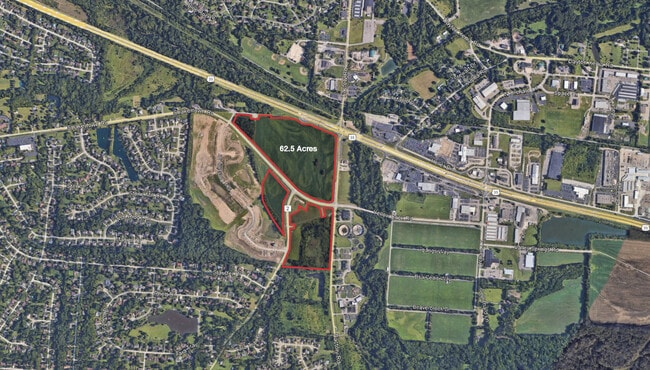
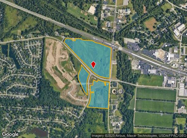
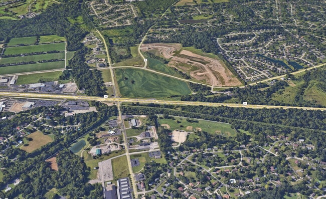
N Alpha Bellbrook Rd
Dayton, OH
Bellbrook
B42-0006-0016-0-0001-00
7/3/2025 N ALPHA BELLBROOK RD
Agriculturalland
Greene
AE
Ohio
39057C0108E
62.59 AC
2024
East Dayton
2024
Cincinnati/Dayton
210602
DEMOGRAPHICS near N Alpha Bellbrook Rd
1 mile
3 mile
5 mile
2024 Total Population
2,803
27,345
90,134
2029 Population
2,854
27,831
91,576
Pop Growth 2024-2029
+ 1.82%
+ 1.78%
+ 1.60%
Average Age
45
43
41
2024 Total Households
1,066
10,136
35,721
HH Growth 2024-2029
+ 1.69%
+ 1.73%
+ 1.47%
Median Household Inc
$130,000
$129,297
$94,853
Avg Household Size
2.60
2.60
2.50
2024 Avg HH Vehicles
3.00
2.00
2.00
Median Home Value
$294,242
$286,504
$226,169
Median Year Built
1977
1977
1976
Nearby Places
Map Layers
Map Styles
 Street
 Aerial
Transit
 Traffic
 Biking
Places
Listings with unknown addresses are not visible on the map
- Restaurants
- Banks
- Shops
- Fitness
- Groceries
PUBLIC TRANSPORTATION
AIRPORT
James M Cox Dayton International
Drive
Walk
Distance
James M Cox Dayton International
36 min
22.6 mi
Freight Ports
Port of Toledo
Drive
Walk
Distance
Port of Toledo
192 min
162.8 mi
Nearby Properties
Address
Land Use
TOTAL SIZE
Lot Size
Zoning
Address
Land Use
TOTAL SIZE
Lot Size
Zoning
286,260 SF
47.65 AC
Address
Land Use
TOTAL SIZE
Lot Size
Zoning
145,500 SF
32.62 AC
A1
Address
Land Use
TOTAL SIZE
Lot Size
Zoning
89,176 SF
17.52 AC
Address
Land Use
TOTAL SIZE
Lot Size
Zoning
108,274 SF
25.09 AC
RPUD427
Address
Land Use
TOTAL SIZE
Lot Size
Zoning
24,992 SF
17 AC
MULTIPLE
Address
Land Use
TOTAL SIZE
Lot Size
Zoning
7,694 SF
20.52 AC
MULTIPLE
Address
Land Use
TOTAL SIZE
Lot Size
Zoning
134,260 SF
11.75 AC
Address
Land Use
TOTAL SIZE
Lot Size
Zoning
26.91 AC
Address
Land Use
TOTAL SIZE
Lot Size
Zoning
2,400 SF
37.61 AC
Address
Land Use
TOTAL SIZE
Lot Size
Zoning
52,262 SF
9.71 AC
Address
Land Use
TOTAL SIZE
Lot Size
Zoning
64,911 SF
12.45 AC
R1A
Address
Land Use
TOTAL SIZE
Lot Size
Zoning
3.54 AC
MULTIPLE
Address
Land Use
TOTAL SIZE
Lot Size
Zoning
41,778 SF
6.82 AC
Address
Land Use
TOTAL SIZE
Lot Size
Zoning
77,673 SF
16.02 AC
A1
Address
Land Use
TOTAL SIZE
Lot Size
Zoning
1,012 SF
464.56 AC
Address
Land Use
TOTAL SIZE
Lot Size
Zoning
40,682 SF
10.31 AC
A1
Address
Land Use
TOTAL SIZE
Lot Size
Zoning
30,056 SF
8.18 AC
Address
Land Use
TOTAL SIZE
Lot Size
Zoning
7,000 SF
5.42 AC
Address
Land Use
TOTAL SIZE
Lot Size
Zoning
27,059 SF
8.99 AC
Address
Land Use
TOTAL SIZE
Lot Size
Zoning
54,191 SF
14.43 AC
A1
Address
Land Use
TOTAL SIZE
Lot Size
Zoning
48,471 SF
15.61 AC
A1
Address
Land Use
TOTAL SIZE
Lot Size
Zoning
110,592 SF
7.22 AC
Address
Land Use
TOTAL SIZE
Lot Size
Zoning
49,686 SF
10 AC
MULTIPLE
Address
Land Use
TOTAL SIZE
Lot Size
Zoning
40,704 SF
6.95 AC
R4
Address
Land Use
TOTAL SIZE
Lot Size
Zoning
21,331 SF
2.34 AC
B2
Address
Land Use
TOTAL SIZE
Lot Size
Zoning
26,942 SF
4.77 AC
Address
Land Use
TOTAL SIZE
Lot Size
Zoning
26,958 SF
2.72 AC
CPUD891
Address
Land Use
TOTAL SIZE
Lot Size
Zoning
94,000 SF
7.64 AC
Address
Land Use
TOTAL SIZE
Lot Size
Zoning
24,940 SF
16 AC
Address
Land Use
TOTAL SIZE
Lot Size
Zoning
3,200 SF
167.63 AC
The World's #1 Commercial Real Estate Marketplace
Connect with us
© 2026 CoStar Group
The information above has been obtained from sources believed reliable. While we do not doubt its accuracy we have not verified it and make no guarantee, warranty or representation about it. It is your responsibility to independently confirm its accuracy and completeness. Any projections, opinions, assumptions, or estimates used are for example only and do not represent the current or future performance of the property. The value of this transaction to you depends on tax and other factors which should be evaluated by your tax, financial, and legal advisors. You and your advisors should conduct a careful, independent investigation of the property to determine to your satisfaction the suitability of the property for your needs.