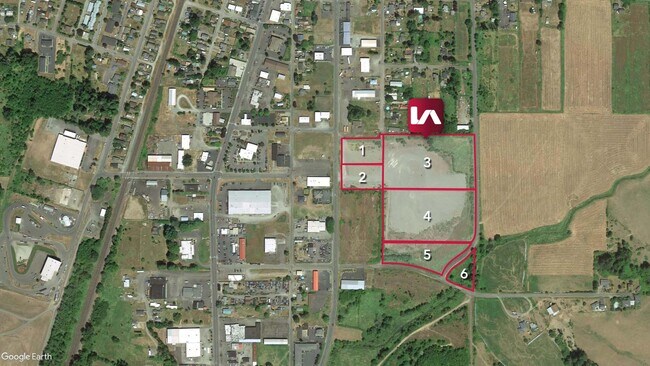
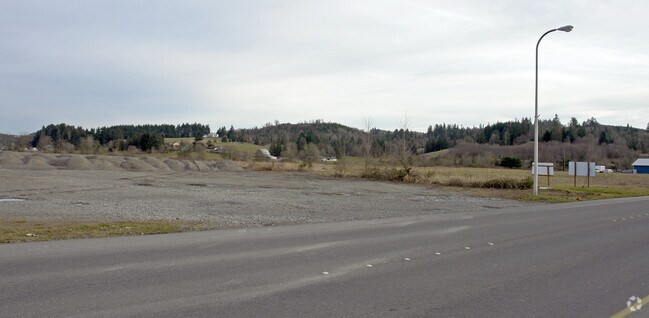
Property Record
Fair St, Centralia, WA 98531
Property Detail
Fair St
Other Market Areas
SECTION 17 TOWNSHIP 14N RANGE 02W PTN LT 20 JOHN GALVINS ADD 2/114 2002266
Centralia, WA
LEWIS
003417-048-872
Washington
Residentialacreage
20
2024
0.60 AC
2025
Washington State Area
970700
NEARBY LISTINGS FOR SALE OR LEASE
DEMOGRAPHICS near Fair St
1 mile
3 mile
5 mile
2025 Total Population
3,962
25,023
37,660
2030 Population
4,119
25,918
38,994
Pop Growth 2025-2030
+ 3.96%
+ 3.58%
+ 3.54%
Average Age
37
40
40
2025 Total Households
1,468
9,677
14,390
HH Growth 2025-2030
+ 3.88%
+ 3.53%
+ 3.52%
Median Household Inc
$63,492
$63,309
$65,274
Avg Household Size
2.60
2.50
2.50
2025 Avg HH Vehicles
2.00
2.00
2.00
Median Home Value
$379,656
$352,643
$361,071
Median Year Built
1962
1975
1976
Nearby Places
Map Layers
Map Styles
 Street
 Aerial
Layers
 Traffic
 Biking
Places
Listings with unknown addresses are not visible on the map
- Restaurants
- Banks
- Shops
- Fitness
- Groceries
PUBLIC TRANSPORTATION
COMMUTER RAIL
Centralia Amtrak Station (Amtrak Cascades - Amtrak, Coast Starlight - Amtrak)
Drive
Walk
Distance
Centralia Amtrak Station (Amtrak Cascades - Amtrak, Coast Starlight - Amtrak)
4 min
1.6 mi
Freight Ports
Port of Long View, WA
Drive
Walk
Distance
Port of Long View, WA
60 min
45.9 mi
SALE & LEASE HISTORY
LISTING DATE
SALE/LEASE

Sep 08, 2020
For Sale
Nearby Properties
Address
Land Use
TOTAL SIZE
Lot Size
Zoning
Address
Land Use
TOTAL SIZE
Lot Size
Zoning
83,945 SF
3.12 AC
ILCG
Address
Land Use
TOTAL SIZE
Lot Size
Zoning
2,003 SF
27.85 AC
LBD
Address
Land Use
TOTAL SIZE
Lot Size
Zoning
62,057 SF
2.08 AC
EPFG
Address
Land Use
TOTAL SIZE
Lot Size
Zoning
1,714 SF
220.30 AC
EPFA
Address
Land Use
TOTAL SIZE
Lot Size
Zoning
222,077 SF
Address
Land Use
TOTAL SIZE
Lot Size
Zoning
25,216 SF
4.99 AC
R15
Address
Land Use
TOTAL SIZE
Lot Size
Zoning
64,421 SF
5 AC
H1
Address
Land Use
TOTAL SIZE
Lot Size
Zoning
7,168 SF
3.95 AC
OSPF
Address
Land Use
TOTAL SIZE
Lot Size
Zoning
43,477 SF
8.64 AC
CG
Address
Land Use
TOTAL SIZE
Lot Size
Zoning
61,308 SF
5.33 AC
H1
Address
Land Use
TOTAL SIZE
Lot Size
Zoning
2.14 AC
C1
Address
Land Use
TOTAL SIZE
Lot Size
Zoning
29,204 SF
3.91 AC
R20
Address
Land Use
TOTAL SIZE
Lot Size
Zoning
3,742 SF
21.83 AC
EPFU
Address
Land Use
TOTAL SIZE
Lot Size
Zoning
34,150 SF
7.20 AC
CG
Address
Land Use
TOTAL SIZE
Lot Size
Zoning
Address
Land Use
TOTAL SIZE
Lot Size
Zoning
Address
Land Use
TOTAL SIZE
Lot Size
Zoning
24,232 SF
4.48 AC
R15
Address
Land Use
TOTAL SIZE
Lot Size
Zoning
48,865 SF
4.70 AC
H1
Address
Land Use
TOTAL SIZE
Lot Size
Zoning
104,872 SF
Address
Land Use
TOTAL SIZE
Lot Size
Zoning
94,044 SF
Address
Land Use
TOTAL SIZE
Lot Size
Zoning
Address
Land Use
TOTAL SIZE
Lot Size
Zoning
13.11 AC
Address
Land Use
TOTAL SIZE
Lot Size
Zoning
36,448 SF
1.73 AC
R20
Address
Land Use
TOTAL SIZE
Lot Size
Zoning
83,043 SF
6.76 AC
CG
Address
Land Use
TOTAL SIZE
Lot Size
Zoning
9,072 SF
8.57 AC
OSPF
Address
Land Use
TOTAL SIZE
Lot Size
Zoning
21,672 SF
2.08 AC
R20
Address
Land Use
TOTAL SIZE
Lot Size
Zoning
30,308 SF
45.31 AC
OSPF
Address
Land Use
TOTAL SIZE
Lot Size
Zoning
1,161 SF
2.11 AC
R15
Address
Land Use
TOTAL SIZE
Lot Size
Zoning
12,850 SF
1.48 AC
R15
Address
Land Use
TOTAL SIZE
Lot Size
Zoning
0.55 AC
C1
The World's #1 Commercial Real Estate Marketplace
Connect with us
© 2026 CoStar Group
The information above has been obtained from sources believed reliable. While we do not doubt its accuracy we have not verified it and make no guarantee, warranty or representation about it. It is your responsibility to independently confirm its accuracy and completeness. Any projections, opinions, assumptions, or estimates used are for example only and do not represent the current or future performance of the property. The value of this transaction to you depends on tax and other factors which should be evaluated by your tax, financial, and legal advisors. You and your advisors should conduct a careful, independent investigation of the property to determine to your satisfaction the suitability of the property for your needs.