Property Record
Fairfield Rd, Howell, NJ 07731

Property Detail
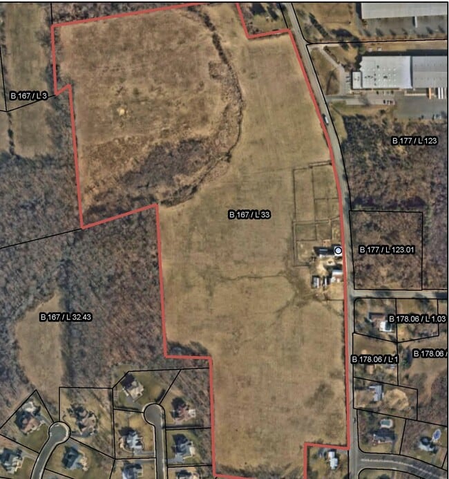
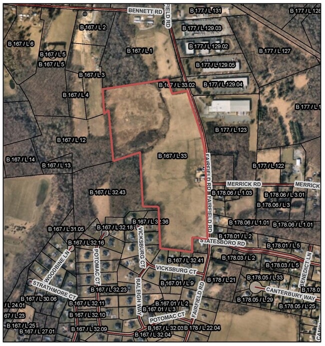
Fairfield Rd
21-00167-0000-00033
MONMOUTH
Farms
New Jersey
ARE6
33
B and X Area of moderate flood hazard, usually the area between the limits of the 100-year and 500-year floods.
0.50 AC
2024
Western Monmouth
2025
Northern New Jersey
811402
Lakewood-New Brunswick, NJ
NEARBY LISTINGS FOR SALE OR LEASE
DEMOGRAPHICS near Fairfield Rd
1 mile
3 mile
5 mile
2025 Total Population
1,899
23,340
76,319
2030 Population
1,871
23,210
75,846
Pop Growth 2025-2030
(1.47%)
(0.56%)
(0.62%)
Average Age
42
44
42
2025 Total Households
642
8,973
26,811
HH Growth 2025-2030
(1.71%)
(0.71%)
(0.82%)
Median Household Inc
$172,680
$113,655
$117,325
Avg Household Size
2.80
2.50
2.80
2025 Avg HH Vehicles
2.00
2.00
2.00
Median Home Value
$744,047
$516,961
$563,954
Median Year Built
1987
1986
1981
Nearby Places
Map Layers
Map Styles
 Street
 Aerial
Layers
 Traffic
 Biking
Places
Listings with unknown addresses are not visible on the map
- Restaurants
- Banks
- Shops
- Fitness
- Groceries
SALE & LEASE HISTORY
LISTING DATE
SALE/LEASE

Aug 07, 2019
For Sale
Nearby Properties
Address
Land Use
TOTAL SIZE
Lot Size
Zoning
Address
Land Use
TOTAL SIZE
Lot Size
Zoning
36.48 AC
HD-2
Address
Land Use
TOTAL SIZE
Lot Size
Zoning
15.69 AC
HMUD
Address
Land Use
TOTAL SIZE
Lot Size
Zoning
25.63 AC
HD-1
Address
Land Use
TOTAL SIZE
Lot Size
Zoning
267,666 SF
29.06 AC
M-1
Address
Land Use
TOTAL SIZE
Lot Size
Zoning
114,738 SF
19.02 AC
M-1
Address
Land Use
TOTAL SIZE
Lot Size
Zoning
13 AC
SF40
Address
Land Use
TOTAL SIZE
Lot Size
Zoning
92,832 SF
29.69 AC
M-1
Address
Land Use
TOTAL SIZE
Lot Size
Zoning
81,657 SF
12.62 AC
B-10
Address
Land Use
TOTAL SIZE
Lot Size
Zoning
126,300 SF
10.12 AC
M-1
Address
Land Use
TOTAL SIZE
Lot Size
Zoning
120,000 SF
77 AC
ARE2
Address
Land Use
TOTAL SIZE
Lot Size
Zoning
12,476 SF
73.93 AC
R-40
Address
Land Use
TOTAL SIZE
Lot Size
Zoning
56,000 SF
21.53 AC
M-1
Address
Land Use
TOTAL SIZE
Lot Size
Zoning
43.22 AC
ARE2
Address
Land Use
TOTAL SIZE
Lot Size
Zoning
106,345 SF
10.53 AC
LI-3
Address
Land Use
TOTAL SIZE
Lot Size
Zoning
240,362 SF
61.13 AC
ARE6
Address
Land Use
TOTAL SIZE
Lot Size
Zoning
155,980 SF
23.83 AC
M-1
Address
Land Use
TOTAL SIZE
Lot Size
Zoning
54,552 SF
8.04 AC
OB01
Address
Land Use
TOTAL SIZE
Lot Size
Zoning
117,975 SF
21.20 AC
C50
Address
Land Use
TOTAL SIZE
Lot Size
Zoning
14.63 AC
HMUD
Address
Land Use
TOTAL SIZE
Lot Size
Zoning
7,966 SF
44.17 AC
MH
Address
Land Use
TOTAL SIZE
Lot Size
Zoning
49.95 AC
M-2
Address
Land Use
TOTAL SIZE
Lot Size
Zoning
161,000 SF
21.60 AC
ARE2
Address
Land Use
TOTAL SIZE
Lot Size
Zoning
61,840 SF
12.32 AC
LI-3
Address
Land Use
TOTAL SIZE
Lot Size
Zoning
2,104 SF
22.90 AC
SF40
Address
Land Use
TOTAL SIZE
Lot Size
Zoning
52,985 SF
20.92 AC
C50
Address
Land Use
TOTAL SIZE
Lot Size
Zoning
55,984 SF
16.11 AC
I0
Address
Land Use
TOTAL SIZE
Lot Size
Zoning
17.44 AC
R-40
Address
Land Use
TOTAL SIZE
Lot Size
Zoning
42,354 SF
0.92 AC
LI-3
Address
Land Use
TOTAL SIZE
Lot Size
Zoning
69,465 SF
7.70 AC
MF08
Address
Land Use
TOTAL SIZE
Lot Size
Zoning
32,800 SF
6.32 AC
LI-3
The World's #1 Commercial Real Estate Marketplace
Connect with us
© 2026 CoStar Group
The information above has been obtained from sources believed reliable. While we do not doubt its accuracy we have not verified it and make no guarantee, warranty or representation about it. It is your responsibility to independently confirm its accuracy and completeness. Any projections, opinions, assumptions, or estimates used are for example only and do not represent the current or future performance of the property. The value of this transaction to you depends on tax and other factors which should be evaluated by your tax, financial, and legal advisors. You and your advisors should conduct a careful, independent investigation of the property to determine to your satisfaction the suitability of the property for your needs.