Property Record
Fairway Ln, Verona, VA 24482

NEARBY LISTINGS FOR SALE OR LEASE
Property Detail
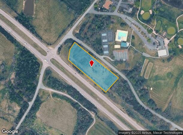
Fairway Ln
Staunton-Waynesboro, VA
Country Club Of Staunton
046A3-1-8
46A3-(1)-8 COUNTRY CLUB OF STAUNTON BLK 8 2.244
Vacantlandnec
Augusta
X
Virginia
51015C0342D
2.24 AC
2025
Staunton & Harrisonburg
2025
Other Market Areas
070701
DEMOGRAPHICS near Fairway Ln
1 Mile
3 Mile
5 Mile
2024 Total Population
251
9,693
39,107
2029 Population
255
9,872
40,080
Pop Growth 2024-2029
+ 1.59%
+ 1.85%
+ 2.49%
Average Age
44
44
42
2024 Total Households
91
3,650
16,401
HH Growth 2024-2029
+ 1.10%
+ 1.89%
+ 2.61%
Median Household Inc
$83,333
$65,305
$57,202
Avg Household Size
2.50
2.20
2.20
2024 Avg HH Vehicles
2.00
2.00
2.00
Median Home Value
$293,749
$249,928
$221,249
Median Year Built
1983
1971
1971
Nearby Places
Map Layers
Map Styles
 Street
 Aerial
- Restaurants
- Banks
- Shops
- Fitness
- Groceries
PUBLIC TRANSPORTATION
COMMUTER RAIL
Staunton Amtrak Station (Cardinal - Amtrak)
DRIVE
WALK
Distance
Staunton Amtrak Station (Cardinal - Amtrak)
7 min
4.7 mi
Freight Ports
Virginia Port Authority - Richmond
DRIVE
WALK
Distance
Virginia Port Authority - Richmond
133 min
115.0 mi
Nearby Properties
Address
Land Use
TOTAL SIZE
Lot Size
Zoning
Address
Land Use
TOTAL SIZE
Lot Size
Zoning
360,085 SF
66.35 AC
I-1
Address
Land Use
TOTAL SIZE
Lot Size
Zoning
262,369 SF
24.50 AC
GENERAL BU
Address
Land Use
TOTAL SIZE
Lot Size
Zoning
43,097 SF
72.85 AC
R3
Address
Land Use
TOTAL SIZE
Lot Size
Zoning
132,832 SF
50.44 AC
GENERAL BU
Address
Land Use
TOTAL SIZE
Lot Size
Zoning
218,331 SF
40 AC
PLANNED CO
Address
Land Use
TOTAL SIZE
Lot Size
Zoning
4,232 SF
12.56 AC
GENERAL IN
Address
Land Use
TOTAL SIZE
Lot Size
Zoning
700,000 SF
46.55 AC
I2
Address
Land Use
TOTAL SIZE
Lot Size
Zoning
515,766 SF
81.76 AC
GENERAL IN
Address
Land Use
TOTAL SIZE
Lot Size
Zoning
32,976 SF
6.20 AC
R4
Address
Land Use
TOTAL SIZE
Lot Size
Zoning
202,650 SF
33.59 AC
B2
Address
Land Use
TOTAL SIZE
Lot Size
Zoning
72,933 SF
8.71 AC
B2
Address
Land Use
TOTAL SIZE
Lot Size
Zoning
101,384 SF
11.77 AC
R3
Address
Land Use
TOTAL SIZE
Lot Size
Zoning
222,668 SF
34.23 AC
I2
Address
Land Use
TOTAL SIZE
Lot Size
Zoning
38,772 SF
8.58 AC
GENERAL BU
Address
Land Use
TOTAL SIZE
Lot Size
Zoning
303,307 SF
146.93 AC
GENERAL IN
Address
Land Use
TOTAL SIZE
Lot Size
Zoning
158,300 SF
30 AC
R2
Address
Land Use
TOTAL SIZE
Lot Size
Zoning
61,798 SF
8.52 AC
R2
Address
Land Use
TOTAL SIZE
Lot Size
Zoning
54,507 SF
2.69 AC
B2
Address
Land Use
TOTAL SIZE
Lot Size
Zoning
56,600 SF
18.89 AC
B2
Address
Land Use
TOTAL SIZE
Lot Size
Zoning
48,904 SF
5.17 AC
P1
Address
Land Use
TOTAL SIZE
Lot Size
Zoning
107,455 SF
5.82 AC
P1
Address
Land Use
TOTAL SIZE
Lot Size
Zoning
121,204 SF
12.99 AC
B2
Address
Land Use
TOTAL SIZE
Lot Size
Zoning
174,284 SF
10.35 AC
GENERAL BU
Address
Land Use
TOTAL SIZE
Lot Size
Zoning
111,992 SF
7.13 AC
PLANNED CO
Address
Land Use
TOTAL SIZE
Lot Size
Zoning
101,604 SF
6.61 AC
R3
Address
Land Use
TOTAL SIZE
Lot Size
Zoning
41,954 SF
3.40 AC
R1
Address
Land Use
TOTAL SIZE
Lot Size
Zoning
43,502 SF
15.61 AC
I2
Address
Land Use
TOTAL SIZE
Lot Size
Zoning
77,592 SF
9.49 AC
GENERAL BU
Address
Land Use
TOTAL SIZE
Lot Size
Zoning
28,142 SF
126.42 AC
SPLIT ZONE
Address
Land Use
TOTAL SIZE
Lot Size
Zoning
20,858 SF
12.73 AC
GENERAL BU
The World's #1 Commercial Real Estate Marketplace
Connect with us
© 2025 CoStar Group
The information above has been obtained from sources believed reliable. While we do not doubt its accuracy we have not verified it and make no guarantee, warranty or representation about it. It is your responsibility to independently confirm its accuracy and completeness. Any projections, opinions, assumptions, or estimates used are for example only and do not represent the current or future performance of the property. The value of this transaction to you depends on tax and other factors which should be evaluated by your tax, financial, and legal advisors. You and your advisors should conduct a careful, independent investigation of the property to determine to your satisfaction the suitability of the property for your needs.