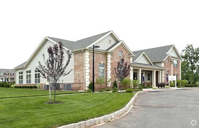
Property Record
Falcon Rd, Hillsborough, NJ 08844

NEARBY LISTINGS FOR SALE OR LEASE
Property Detail
Falcon Rd
Newark, NJ-PA
ADDITIONAL LOTS: 252 UNITS
10-00141-0000-00007-02
Somerset
Apartment
New Jersey
X
7.2
34035C0163F
43.66 AC
2024
Outlying Somerset County
2025
Northern New Jersey
053806
DEMOGRAPHICS near Falcon Rd
1 Mile
3 Mile
5 Mile
2024 Total Population
5,746
44,876
116,069
2029 Population
5,791
44,856
116,416
Pop Growth 2024-2029
+ 0.78%
(0.04%)
+ 0.30%
Average Age
42
42
42
2024 Total Households
2,249
17,003
43,376
HH Growth 2024-2029
+ 0.76%
(0.04%)
+ 0.34%
Median Household Inc
$110,604
$117,006
$119,364
Avg Household Size
2.40
2.60
2.60
2024 Avg HH Vehicles
2.00
2.00
2.00
Median Home Value
$446,543
$391,679
$432,067
Median Year Built
2001
1982
1982
Nearby Places
Map Layers
Map Styles
 Street
 Aerial
- Restaurants
- Banks
- Shops
- Fitness
- Groceries
PUBLIC TRANSPORTATION
COMMUTER RAIL
Somerville (Raritan Valley Line - NJ Transit Commuter Rail (NJ Transit))
DRIVE
WALK
Distance
Somerville (Raritan Valley Line - NJ Transit Commuter Rail (NJ Transit))
10 min
4.6 mi
Raritan (Raritan Valley Line - NJ Transit Commuter Rail (NJ Transit))
DRIVE
WALK
Distance
Raritan (Raritan Valley Line - NJ Transit Commuter Rail (NJ Transit))
11 min
5.7 mi
AIRPORT
Trenton Mercer
DRIVE
WALK
Distance
Trenton Mercer
45 min
26.9 mi
Newark Liberty International
DRIVE
WALK
Distance
Newark Liberty International
50 min
39.3 mi
Freight Ports
New York Container Terminal
DRIVE
WALK
Distance
New York Container Terminal
50 min
33.6 mi
Nearby Properties
Address
Land Use
TOTAL SIZE
Lot Size
Zoning
Address
Land Use
TOTAL SIZE
Lot Size
Zoning
22.36 AC
PAC
Address
Land Use
TOTAL SIZE
Lot Size
Zoning
153 AC
Address
Land Use
TOTAL SIZE
Lot Size
Zoning
Address
Land Use
TOTAL SIZE
Lot Size
Zoning
10.31 AC
PDRD
Address
Land Use
TOTAL SIZE
Lot Size
Zoning
2,488 SF
16.46 AC
PAC
Address
Land Use
TOTAL SIZE
Lot Size
Zoning
26.53 AC
B-I
Address
Land Use
TOTAL SIZE
Lot Size
Zoning
19,528 SF
52.97 AC
02
Address
Land Use
TOTAL SIZE
Lot Size
Zoning
289,939 SF
27.31 AC
MUID
Address
Land Use
TOTAL SIZE
Lot Size
Zoning
14.06 AC
GV
Address
Land Use
TOTAL SIZE
Lot Size
Zoning
61,757 SF
8.75 AC
TC
Address
Land Use
TOTAL SIZE
Lot Size
Zoning
27.06 AC
GV
Address
Land Use
TOTAL SIZE
Lot Size
Zoning
Address
Land Use
TOTAL SIZE
Lot Size
Zoning
48 AC
R1
Address
Land Use
TOTAL SIZE
Lot Size
Zoning
114.10 AC
M2
Address
Land Use
TOTAL SIZE
Lot Size
Zoning
1,383 SF
259.46 AC
ED
Address
Land Use
TOTAL SIZE
Lot Size
Zoning
780 SF
9.89 AC
GA
Address
Land Use
TOTAL SIZE
Lot Size
Zoning
3,897 SF
10.36 AC
A
Address
Land Use
TOTAL SIZE
Lot Size
Zoning
Address
Land Use
TOTAL SIZE
Lot Size
Zoning
1,440 SF
19.33 AC
TC
Address
Land Use
TOTAL SIZE
Lot Size
Zoning
31.27 AC
Address
Land Use
TOTAL SIZE
Lot Size
Zoning
1,096 SF
17.75 AC
TC
Address
Land Use
TOTAL SIZE
Lot Size
Zoning
22.95 AC
ARPD
Address
Land Use
TOTAL SIZE
Lot Size
Zoning
1.81 AC
B-3
Address
Land Use
TOTAL SIZE
Lot Size
Zoning
27.10 AC
Address
Land Use
TOTAL SIZE
Lot Size
Zoning
8.61 AC
R10
Address
Land Use
TOTAL SIZE
Lot Size
Zoning
29.28 AC
A
Address
Land Use
TOTAL SIZE
Lot Size
Zoning
20.04 AC
R10
Address
Land Use
TOTAL SIZE
Lot Size
Zoning
186,180 SF
16.41 AC
PD
Address
Land Use
TOTAL SIZE
Lot Size
Zoning
The World's #1 Commercial Real Estate Marketplace
Connect with us
© 2025 CoStar Group
The information above has been obtained from sources believed reliable. While we do not doubt its accuracy we have not verified it and make no guarantee, warranty or representation about it. It is your responsibility to independently confirm its accuracy and completeness. Any projections, opinions, assumptions, or estimates used are for example only and do not represent the current or future performance of the property. The value of this transaction to you depends on tax and other factors which should be evaluated by your tax, financial, and legal advisors. You and your advisors should conduct a careful, independent investigation of the property to determine to your satisfaction the suitability of the property for your needs.