Property Record
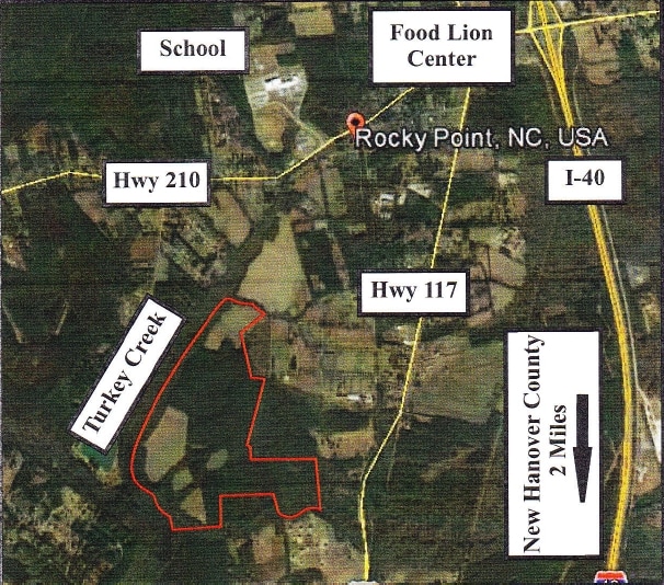
117 S S Us Hwy, Rocky Point, NC 28457

Property Detail
117 S S Us Hwy
3234-24-6900-0000
TR 2 PB 52/101 RECOMB TURKEY CR
Vacantlandnec
PENDER
SEEMAP
North Carolina
AE The base floodplain where base flood elevations are provided. AE Zones are now used on new format FIRMs instead of A1-A30 Zones.
208.64 AC
2025
West Pender County
2025
Wilmington
920601
Wilmington, NC
NEARBY LISTINGS FOR SALE OR LEASE
DEMOGRAPHICS near 117 S S Us Hwy
1 mile
3 mile
5 mile
2024 Total Population
998
6,518
11,218
2029 Population
1,124
7,289
12,472
Pop Growth 2024-2029
+ 12.63%
+ 11.83%
+ 11.18%
Average Age
39
39
39
2024 Total Households
354
2,375
4,155
HH Growth 2024-2029
+ 12.99%
+ 12.08%
+ 11.36%
Median Household Inc
$86,574
$64,485
$65,852
Avg Household Size
2.70
2.70
2.60
2024 Avg HH Vehicles
2.00
2.00
2.00
Median Home Value
$265,104
$259,061
$267,600
Median Year Built
1995
1996
1996
Nearby Places
Map Layers
Map Styles
 Street
 Aerial
Transit
 Traffic
 Biking
Places
Listings with unknown addresses are not visible on the map
- Restaurants
- Banks
- Shops
- Fitness
- Groceries
PUBLIC TRANSPORTATION
AIRPORT
Wilmington International
Drive
Walk
Distance
Wilmington International
24 min
12.3 mi
Freight Ports
Port of Wilmington
Drive
Walk
Distance
Port of Wilmington
33 min
20.2 mi
SALE & LEASE HISTORY
LISTING DATE
SALE/LEASE

Sep 24, 2016
For Sale
Feb 13, 2017
For Sale
Nearby Properties
Address
Land Use
TOTAL SIZE
Lot Size
Zoning
Address
Land Use
TOTAL SIZE
Lot Size
Zoning
59,264 SF
20 AC
OI
Address
Land Use
TOTAL SIZE
Lot Size
Zoning
61,273 SF
22.01 AC
SEEMAP
Address
Land Use
TOTAL SIZE
Lot Size
Zoning
20,040 SF
6.85 AC
RT
Address
Land Use
TOTAL SIZE
Lot Size
Zoning
27,324 SF
106.68 AC
SEEMAP
Address
Land Use
TOTAL SIZE
Lot Size
Zoning
22,500 SF
3 AC
B2
Address
Land Use
TOTAL SIZE
Lot Size
Zoning
27,154 SF
3.80 AC
B2
Address
Land Use
TOTAL SIZE
Lot Size
Zoning
24,795 SF
55.80 AC
SEEMAP
Address
Land Use
TOTAL SIZE
Lot Size
Zoning
18,900 SF
3.57 AC
GB
Address
Land Use
TOTAL SIZE
Lot Size
Zoning
14,040 SF
58.51 AC
SEEMAP
Address
Land Use
TOTAL SIZE
Lot Size
Zoning
133.10 AC
RA
Address
Land Use
TOTAL SIZE
Lot Size
Zoning
497.70 AC
Address
Land Use
TOTAL SIZE
Lot Size
Zoning
8,422 SF
4.29 AC
B2
Address
Land Use
TOTAL SIZE
Lot Size
Zoning
15,000 SF
3.85 AC
B2
Address
Land Use
TOTAL SIZE
Lot Size
Zoning
1,008 SF
5.36 AC
R20
Address
Land Use
TOTAL SIZE
Lot Size
Zoning
33,478 SF
7.59 AC
R20
Address
Land Use
TOTAL SIZE
Lot Size
Zoning
476.82 AC
Address
Land Use
TOTAL SIZE
Lot Size
Zoning
15,209 SF
1.79 AC
B2
Address
Land Use
TOTAL SIZE
Lot Size
Zoning
6,396 SF
1.03 AC
B2
Address
Land Use
TOTAL SIZE
Lot Size
Zoning
7,200 SF
2.45 AC
R20
Address
Land Use
TOTAL SIZE
Lot Size
Zoning
378.95 AC
Address
Land Use
TOTAL SIZE
Lot Size
Zoning
800 SF
20.22 AC
B2
Address
Land Use
TOTAL SIZE
Lot Size
Zoning
8,820 SF
6.67 AC
Address
Land Use
TOTAL SIZE
Lot Size
Zoning
9,880 SF
4.51 AC
PD
Address
Land Use
TOTAL SIZE
Lot Size
Zoning
6,416 SF
3.81 AC
B2
Address
Land Use
TOTAL SIZE
Lot Size
Zoning
8,120 SF
1.38 AC
GB
Address
Land Use
TOTAL SIZE
Lot Size
Zoning
7,215 SF
3.42 AC
B2
Address
Land Use
TOTAL SIZE
Lot Size
Zoning
928 SF
365.65 AC
SEEMAP
Address
Land Use
TOTAL SIZE
Lot Size
Zoning
317.50 AC
SEEMAP
Address
Land Use
TOTAL SIZE
Lot Size
Zoning
6,600 SF
0.92 AC
B2
Address
Land Use
TOTAL SIZE
Lot Size
Zoning
270.78 AC
The World's #1 Commercial Real Estate Marketplace
Connect with us
© 2026 CoStar Group
The information above has been obtained from sources believed reliable. While we do not doubt its accuracy we have not verified it and make no guarantee, warranty or representation about it. It is your responsibility to independently confirm its accuracy and completeness. Any projections, opinions, assumptions, or estimates used are for example only and do not represent the current or future performance of the property. The value of this transaction to you depends on tax and other factors which should be evaluated by your tax, financial, and legal advisors. You and your advisors should conduct a careful, independent investigation of the property to determine to your satisfaction the suitability of the property for your needs.