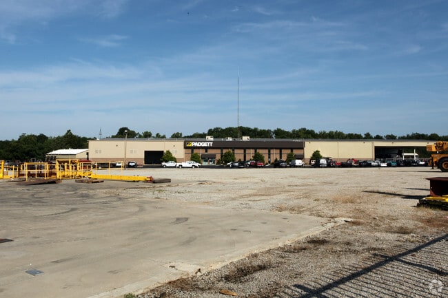
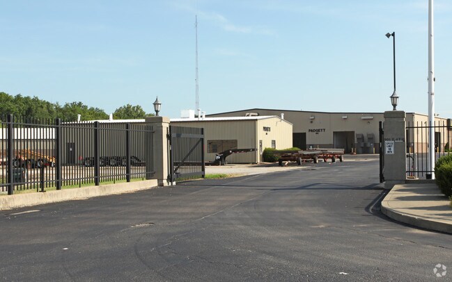
Property Record
Falling Run, New Albany, IN 47150
Property Detail
Falling Run
Louisville/Jefferson County, KY-IN
35-2-6 2.6565 A.
22-05-03-500-370.000-008
FLOYD
Manufacturinglight
Indiana
AE The base floodplain where base flood elevations are provided. AE Zones are now used on new format FIRMs instead of A1-A30 Zones.
a
2025
8.40 AC
2025
New Albany
070500
Louisville
NEARBY LISTINGS FOR SALE OR LEASE
DEMOGRAPHICS near Falling Run
1 mile
3 mile
5 mile
2025 Total Population
11,825
65,145
149,035
2030 Population
12,221
67,200
154,995
Pop Growth 2025-2030
+ 3.35%
+ 3.15%
+ 4.00%
Average Age
38
40
40
2025 Total Households
5,147
27,523
62,394
HH Growth 2025-2030
+ 3.50%
+ 3.13%
+ 4.19%
Median Household Inc
$41,959
$48,652
$49,071
Avg Household Size
2.10
2.30
2.20
2025 Avg HH Vehicles
1.00
2.00
1.00
Median Home Value
$154,670
$156,699
$164,920
Median Year Built
1948
1950
1958
Nearby Places
Map Layers
Map Styles
 Street
 Aerial
Transit
 Traffic
 Biking
Places
Listings with unknown addresses are not visible on the map
- Restaurants
- Banks
- Shops
- Fitness
- Groceries
PUBLIC TRANSPORTATION
AIRPORT
Louisville Muhammad Ali International
Drive
Walk
Distance
Louisville Muhammad Ali International
24 min
12.9 mi
Freight Ports
Port of Toledo
Drive
Walk
Distance
Port of Toledo
361 min
310.2 mi
Nearby Properties
Address
Land Use
TOTAL SIZE
Lot Size
Zoning
Address
Land Use
TOTAL SIZE
Lot Size
Zoning
175,626 SF
60.10 AC
Address
Land Use
TOTAL SIZE
Lot Size
Zoning
12,270 SF
13.50 AC
Address
Land Use
TOTAL SIZE
Lot Size
Zoning
25,728 SF
10.37 AC
Address
Land Use
TOTAL SIZE
Lot Size
Zoning
3,692 SF
15.99 AC
Address
Land Use
TOTAL SIZE
Lot Size
Zoning
143,700 SF
0.29 AC
Address
Land Use
TOTAL SIZE
Lot Size
Zoning
202,859 SF
22.95 AC
Address
Land Use
TOTAL SIZE
Lot Size
Zoning
169 SF
35.25 AC
Address
Land Use
TOTAL SIZE
Lot Size
Zoning
34,308 SF
4.59 AC
Address
Land Use
TOTAL SIZE
Lot Size
Zoning
72,332 SF
2.48 AC
Address
Land Use
TOTAL SIZE
Lot Size
Zoning
83,084 SF
14.65 AC
Address
Land Use
TOTAL SIZE
Lot Size
Zoning
35,044 SF
3.39 AC
Address
Land Use
TOTAL SIZE
Lot Size
Zoning
67,600 SF
6.76 AC
EZ1-ENTERP
Address
Land Use
TOTAL SIZE
Lot Size
Zoning
75,310 SF
0.83 AC
Address
Land Use
TOTAL SIZE
Lot Size
Zoning
118,371 SF
11.83 AC
Address
Land Use
TOTAL SIZE
Lot Size
Zoning
26,532 SF
4.35 AC
Address
Land Use
TOTAL SIZE
Lot Size
Zoning
3,360 SF
9.40 AC
Address
Land Use
TOTAL SIZE
Lot Size
Zoning
7,496 SF
9.37 AC
Address
Land Use
TOTAL SIZE
Lot Size
Zoning
65,748 SF
4.34 AC
Address
Land Use
TOTAL SIZE
Lot Size
Zoning
75,898 SF
2.16 AC
Address
Land Use
TOTAL SIZE
Lot Size
Zoning
301,104 SF
15.74 AC
Address
Land Use
TOTAL SIZE
Lot Size
Zoning
42,344 SF
6.77 AC
Address
Land Use
TOTAL SIZE
Lot Size
Zoning
59,998 SF
7.28 AC
Address
Land Use
TOTAL SIZE
Lot Size
Zoning
1,758 SF
10.41 AC
Address
Land Use
TOTAL SIZE
Lot Size
Zoning
48,490 SF
0.28 AC
Address
Land Use
TOTAL SIZE
Lot Size
Zoning
185,587 SF
4.30 AC
Address
Land Use
TOTAL SIZE
Lot Size
Zoning
43,567 SF
2.12 AC
Address
Land Use
TOTAL SIZE
Lot Size
Zoning
29,354 SF
2.98 AC
R5-RESIDEN
Address
Land Use
TOTAL SIZE
Lot Size
Zoning
3,312 SF
32.13 AC
Address
Land Use
TOTAL SIZE
Lot Size
Zoning
131,952 SF
4.32 AC
Address
Land Use
TOTAL SIZE
Lot Size
Zoning
19,362 SF
8.60 AC
The World's #1 Commercial Real Estate Marketplace
Connect with us
© 2026 CoStar Group
The information above has been obtained from sources believed reliable. While we do not doubt its accuracy we have not verified it and make no guarantee, warranty or representation about it. It is your responsibility to independently confirm its accuracy and completeness. Any projections, opinions, assumptions, or estimates used are for example only and do not represent the current or future performance of the property. The value of this transaction to you depends on tax and other factors which should be evaluated by your tax, financial, and legal advisors. You and your advisors should conduct a careful, independent investigation of the property to determine to your satisfaction the suitability of the property for your needs.