Property Record
Fannin Ave, Denison, TX 75021


Property Detail
Fannin Ave
Sherman-Denison, TX
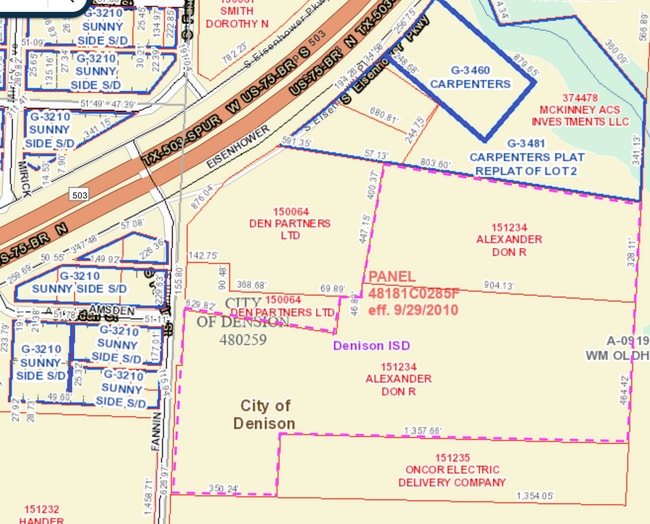
G-0919 OLDHAM WILLIAM A-G0919, ACRES 25.356
151234
GRAYSON
Commercialacreage
Texas
B and X Area of moderate flood hazard, usually the area between the limits of the 100-year and 500-year floods.
25.36 AC
2024
Denison
2025
Other Market Areas
000600
NEARBY LISTINGS FOR SALE OR LEASE
DEMOGRAPHICS near Fannin Ave
1 mile
3 mile
5 mile
2024 Total Population
3,007
24,760
35,259
2029 Population
3,299
27,151
38,601
Pop Growth 2024-2029
+ 9.71%
+ 9.66%
+ 9.48%
Average Age
39
41
41
2024 Total Households
1,204
9,709
13,939
HH Growth 2024-2029
+ 9.72%
+ 9.68%
+ 9.53%
Median Household Inc
$56,163
$58,956
$60,291
Avg Household Size
2.50
2.50
2.40
2024 Avg HH Vehicles
2.00
2.00
2.00
Median Home Value
$182,662
$204,056
$225,874
Median Year Built
1968
1972
1977
Nearby Places
Map Layers
Map Styles
 Street
 Aerial
Transit
 Traffic
 Biking
Places
Listings with unknown addresses are not visible on the map
- Restaurants
- Banks
- Shops
- Fitness
- Groceries
SALE & LEASE HISTORY
LISTING DATE
SALE/LEASE

Jun 24, 2021
For Sale
Nearby Properties
Address
Land Use
TOTAL SIZE
Lot Size
Zoning
Address
Land Use
TOTAL SIZE
Lot Size
Zoning
618,286 SF
33.55 AC
Address
Land Use
TOTAL SIZE
Lot Size
Zoning
121,512 SF
Address
Land Use
TOTAL SIZE
Lot Size
Zoning
141,330 SF
15 AC
Address
Land Use
TOTAL SIZE
Lot Size
Zoning
66,077 SF
10 AC
Address
Land Use
TOTAL SIZE
Lot Size
Zoning
83,418 SF
Address
Land Use
TOTAL SIZE
Lot Size
Zoning
263,952 SF
34.25 AC
Address
Land Use
TOTAL SIZE
Lot Size
Zoning
69,762 SF
12.13 AC
Address
Land Use
TOTAL SIZE
Lot Size
Zoning
112,048 SF
8.66 AC
Address
Land Use
TOTAL SIZE
Lot Size
Zoning
54.88 AC
Address
Land Use
TOTAL SIZE
Lot Size
Zoning
63,575 SF
2.07 AC
Address
Land Use
TOTAL SIZE
Lot Size
Zoning
69,338 SF
6.90 AC
Address
Land Use
TOTAL SIZE
Lot Size
Zoning
67,498 SF
6.43 AC
Address
Land Use
TOTAL SIZE
Lot Size
Zoning
76,800 SF
5.02 AC
Address
Land Use
TOTAL SIZE
Lot Size
Zoning
66,216 SF
10.15 AC
Address
Land Use
TOTAL SIZE
Lot Size
Zoning
97,136 SF
6.38 AC
Address
Land Use
TOTAL SIZE
Lot Size
Zoning
67,952 SF
4.72 AC
Address
Land Use
TOTAL SIZE
Lot Size
Zoning
135,984 SF
9.21 AC
Address
Land Use
TOTAL SIZE
Lot Size
Zoning
6,354 SF
12.45 AC
Address
Land Use
TOTAL SIZE
Lot Size
Zoning
141,948 SF
33.33 AC
Address
Land Use
TOTAL SIZE
Lot Size
Zoning
37,857 SF
19.38 AC
Address
Land Use
TOTAL SIZE
Lot Size
Zoning
27,136 SF
0.83 AC
Address
Land Use
TOTAL SIZE
Lot Size
Zoning
54,356 SF
7.68 AC
Address
Land Use
TOTAL SIZE
Lot Size
Zoning
44,928 SF
13.17 AC
Address
Land Use
TOTAL SIZE
Lot Size
Zoning
16,620 SF
2.51 AC
Address
Land Use
TOTAL SIZE
Lot Size
Zoning
24,227 SF
0.74 AC
Address
Land Use
TOTAL SIZE
Lot Size
Zoning
27,650 SF
7.21 AC
Address
Land Use
TOTAL SIZE
Lot Size
Zoning
195,496 SF
13.24 AC
Address
Land Use
TOTAL SIZE
Lot Size
Zoning
40,825 SF
4.95 AC
Address
Land Use
TOTAL SIZE
Lot Size
Zoning
36,380 SF
5.99 AC
Address
Land Use
TOTAL SIZE
Lot Size
Zoning
25,108 SF
10.76 AC
The World's #1 Commercial Real Estate Marketplace
Connect with us
© 2026 CoStar Group
The information above has been obtained from sources believed reliable. While we do not doubt its accuracy we have not verified it and make no guarantee, warranty or representation about it. It is your responsibility to independently confirm its accuracy and completeness. Any projections, opinions, assumptions, or estimates used are for example only and do not represent the current or future performance of the property. The value of this transaction to you depends on tax and other factors which should be evaluated by your tax, financial, and legal advisors. You and your advisors should conduct a careful, independent investigation of the property to determine to your satisfaction the suitability of the property for your needs.