Property Record
Farmdale Ave, Hesperia, CA 92345

NEARBY LISTINGS FOR SALE OR LEASE
Property Detail
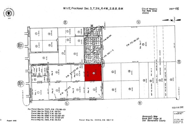
Farmdale Ave
Riverside-San Bernardino-Ontario, CA
Parcel Map No 5781
0397-161-08
PARCEL MAP 5781 PARCEL 4 EX ST
Vacantlandnec
San Bernardino
X
California
06071C6495H
8.52 AC
2024
Mojave River Valley
2025
Inland Empire (California)
010019
DEMOGRAPHICS near Farmdale Ave
1 Mile
3 Mile
5 Mile
2024 Total Population
3,252
32,828
70,900
2029 Population
3,310
33,346
72,050
Pop Growth 2024-2029
+ 1.78%
+ 1.58%
+ 1.62%
Average Age
39
37
36
2024 Total Households
1,012
10,274
21,135
HH Growth 2024-2029
+ 1.88%
+ 1.58%
+ 1.61%
Median Household Inc
$75,825
$59,666
$62,320
Avg Household Size
3.10
3.10
3.30
2024 Avg HH Vehicles
2.00
2.00
2.00
Median Home Value
$386,415
$352,289
$347,984
Median Year Built
1985
1984
1985
Nearby Places
Map Layers
Map Styles
 Street
 Aerial
- Restaurants
- Banks
- Shops
- Fitness
- Groceries
PUBLIC TRANSPORTATION
AIRPORT
Ontario International
DRIVE
WALK
Distance
Ontario International
54 min
40.7 mi
Freight Ports
Port of Long Beach
DRIVE
WALK
Distance
Port of Long Beach
116 min
92.8 mi
SALE & LEASE HISTORY
LISTING DATE
SALE/LEASE

Apr 29, 2022
For Sale
Apr 06, 2021
For Sale
Nearby Properties
Address
Land Use
TOTAL SIZE
Lot Size
Zoning
Address
Land Use
TOTAL SIZE
Lot Size
Zoning
213,482 SF
19.98 AC
Address
Land Use
TOTAL SIZE
Lot Size
Zoning
158,417 SF
9.66 AC
Address
Land Use
TOTAL SIZE
Lot Size
Zoning
174,855 SF
15.46 AC
Address
Land Use
TOTAL SIZE
Lot Size
Zoning
119,525 SF
6.42 AC
Address
Land Use
TOTAL SIZE
Lot Size
Zoning
125,694 SF
10.51 AC
Address
Land Use
TOTAL SIZE
Lot Size
Zoning
70,023 SF
4.52 AC
Address
Land Use
TOTAL SIZE
Lot Size
Zoning
69,000 SF
3.17 AC
Address
Land Use
TOTAL SIZE
Lot Size
Zoning
78,412 SF
4 AC
Address
Land Use
TOTAL SIZE
Lot Size
Zoning
Address
Land Use
TOTAL SIZE
Lot Size
Zoning
88,870 SF
5.97 AC
Address
Land Use
TOTAL SIZE
Lot Size
Zoning
14,488 SF
1.62 AC
Address
Land Use
TOTAL SIZE
Lot Size
Zoning
33,032 SF
2.22 AC
Address
Land Use
TOTAL SIZE
Lot Size
Zoning
44,548 SF
5.52 AC
Address
Land Use
TOTAL SIZE
Lot Size
Zoning
38,099 SF
2.45 AC
Address
Land Use
TOTAL SIZE
Lot Size
Zoning
32,855 SF
2 AC
Address
Land Use
TOTAL SIZE
Lot Size
Zoning
59,632 SF
2.70 AC
Address
Land Use
TOTAL SIZE
Lot Size
Zoning
96,504 SF
10.99 AC
Address
Land Use
TOTAL SIZE
Lot Size
Zoning
77,794 SF
5.43 AC
Address
Land Use
TOTAL SIZE
Lot Size
Zoning
51,070 SF
3.87 AC
Address
Land Use
TOTAL SIZE
Lot Size
Zoning
9,187 SF
1.11 AC
Address
Land Use
TOTAL SIZE
Lot Size
Zoning
2,497 SF
0.94 AC
Address
Land Use
TOTAL SIZE
Lot Size
Zoning
26,440 SF
2 AC
Address
Land Use
TOTAL SIZE
Lot Size
Zoning
8,095 SF
1.54 AC
Address
Land Use
TOTAL SIZE
Lot Size
Zoning
1,850 SF
0.61 AC
Address
Land Use
TOTAL SIZE
Lot Size
Zoning
87,660 SF
5.24 AC
Address
Land Use
TOTAL SIZE
Lot Size
Zoning
34,480 SF
3.50 AC
Address
Land Use
TOTAL SIZE
Lot Size
Zoning
5,803 SF
0.87 AC
Address
Land Use
TOTAL SIZE
Lot Size
Zoning
21,994 SF
4.60 AC
Address
Land Use
TOTAL SIZE
Lot Size
Zoning
25,200 SF
2.56 AC
Address
Land Use
TOTAL SIZE
Lot Size
Zoning
21,000 SF
3.53 AC
The World's #1 Commercial Real Estate Marketplace
Connect with us
© 2025 CoStar Group
The information above has been obtained from sources believed reliable. While we do not doubt its accuracy we have not verified it and make no guarantee, warranty or representation about it. It is your responsibility to independently confirm its accuracy and completeness. Any projections, opinions, assumptions, or estimates used are for example only and do not represent the current or future performance of the property. The value of this transaction to you depends on tax and other factors which should be evaluated by your tax, financial, and legal advisors. You and your advisors should conduct a careful, independent investigation of the property to determine to your satisfaction the suitability of the property for your needs.