Property Record
Farnsley Rd, Shively, KY 40216
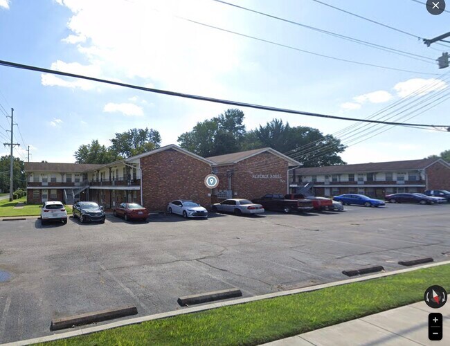
Property Detail
Farnsley Rd
100903500000
98 X 153 S E COR FARNSLEY RD HOTTELL DR
Apartment
JEFFERSON
R6-RESIDEN
Kentucky
B and X Area of moderate flood hazard, usually the area between the limits of the 100-year and 500-year floods.
0.10 AC
2025
Shively
2025
Louisville
012605
Louisville/Jefferson County, KY-IN
NEARBY LISTINGS FOR SALE OR LEASE
-
-
-
No Photo
-
-
View all Shively listings for sale on LoopNet.com
DEMOGRAPHICS near Farnsley Rd
1 mile
3 mile
5 mile
2025 Total Population
12,310
106,914
240,643
2030 Population
12,552
110,266
248,161
Pop Growth 2025-2030
+ 1.97%
+ 3.14%
+ 3.12%
Average Age
39
38
39
2025 Total Households
5,067
42,932
100,603
HH Growth 2025-2030
+ 2.07%
+ 3.24%
+ 3.26%
Median Household Inc
$39,801
$43,038
$44,118
Avg Household Size
2.30
2.30
2.20
2025 Avg HH Vehicles
1.00
1.00
1.00
Median Home Value
$159,610
$136,021
$160,101
Median Year Built
1962
1955
1955
Nearby Places
Map Layers
Map Styles
 Street
 Aerial
Layers
 Traffic
 Biking
Places
Listings with unknown addresses are not visible on the map
- Restaurants
- Banks
- Shops
- Fitness
- Groceries
PUBLIC TRANSPORTATION
AIRPORT
Louisville Muhammad Ali International
Drive
Walk
Distance
Louisville Muhammad Ali International
14 min
6.7 mi
Freight Ports
Port of Toledo
Drive
Walk
Distance
Port of Toledo
363 min
310.7 mi
Nearby Properties
Address
Land Use
TOTAL SIZE
Lot Size
Zoning
Address
Land Use
TOTAL SIZE
Lot Size
Zoning
42,228 SF
144.63 AC
R5-RESIDEN
Address
Land Use
TOTAL SIZE
Lot Size
Zoning
17,916 SF
21.76 AC
EZ1-ENTERP
Address
Land Use
TOTAL SIZE
Lot Size
Zoning
260,488 SF
8.07 AC
EZ1-ENTERP
Address
Land Use
TOTAL SIZE
Lot Size
Zoning
Address
Land Use
TOTAL SIZE
Lot Size
Zoning
6.75 AC
M2-INDUSTR
Address
Land Use
TOTAL SIZE
Lot Size
Zoning
19.50 AC
Address
Land Use
TOTAL SIZE
Lot Size
Zoning
194,084 SF
24.87 AC
EZ1-ENTERP
Address
Land Use
TOTAL SIZE
Lot Size
Zoning
16.31 AC
OR1-OFFICE
Address
Land Use
TOTAL SIZE
Lot Size
Zoning
3,162 SF
23.76 AC
EZ1-ENTERP
Address
Land Use
TOTAL SIZE
Lot Size
Zoning
17,444 SF
1.47 AC
C2-COMMERC
Address
Land Use
TOTAL SIZE
Lot Size
Zoning
2.62 AC
OR2-OFFICE
Address
Land Use
TOTAL SIZE
Lot Size
Zoning
9,323 SF
31.90 AC
EZ1-ENTERP
Address
Land Use
TOTAL SIZE
Lot Size
Zoning
38.34 AC
Address
Land Use
TOTAL SIZE
Lot Size
Zoning
308 SF
57.16 AC
EZ1-ENTERP
Address
Land Use
TOTAL SIZE
Lot Size
Zoning
270 SF
121 AC
M3-INDUSTR
Address
Land Use
TOTAL SIZE
Lot Size
Zoning
164,677 SF
13.54 AC
EZ1-ENTERP
Address
Land Use
TOTAL SIZE
Lot Size
Zoning
139,200 SF
29.50 AC
EZ1-ENTERP
Address
Land Use
TOTAL SIZE
Lot Size
Zoning
29.54 AC
R5-RESIDEN
Address
Land Use
TOTAL SIZE
Lot Size
Zoning
4,250 SF
2.83 AC
OR1-OFFICE
Address
Land Use
TOTAL SIZE
Lot Size
Zoning
21.36 AC
Address
Land Use
TOTAL SIZE
Lot Size
Zoning
295,410 SF
15.35 AC
EZ1-ENTERP
Address
Land Use
TOTAL SIZE
Lot Size
Zoning
11,136 SF
11.02 AC
R4-RESIDEN
Address
Land Use
TOTAL SIZE
Lot Size
Zoning
15,928 SF
13.67 AC
R4-RESIDEN
Address
Land Use
TOTAL SIZE
Lot Size
Zoning
Address
Land Use
TOTAL SIZE
Lot Size
Zoning
19,000 SF
12.86 AC
EZ1-ENTERP
Address
Land Use
TOTAL SIZE
Lot Size
Zoning
19,375 SF
10.11 AC
C1-COMMERC
Address
Land Use
TOTAL SIZE
Lot Size
Zoning
121,509 SF
4.48 AC
Address
Land Use
TOTAL SIZE
Lot Size
Zoning
20,258 SF
60.94 AC
M3-INDUSTR
Address
Land Use
TOTAL SIZE
Lot Size
Zoning
91,913 SF
2.46 AC
C2-COMMERC
Address
Land Use
TOTAL SIZE
Lot Size
Zoning
231,530 SF
12.37 AC
EZ1-ENTERP
The World's #1 Commercial Real Estate Marketplace
Connect with us
© 2026 CoStar Group
The information above has been obtained from sources believed reliable. While we do not doubt its accuracy we have not verified it and make no guarantee, warranty or representation about it. It is your responsibility to independently confirm its accuracy and completeness. Any projections, opinions, assumptions, or estimates used are for example only and do not represent the current or future performance of the property. The value of this transaction to you depends on tax and other factors which should be evaluated by your tax, financial, and legal advisors. You and your advisors should conduct a careful, independent investigation of the property to determine to your satisfaction the suitability of the property for your needs.