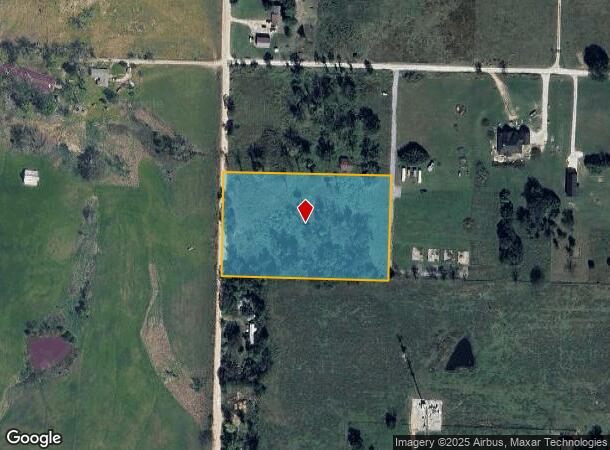
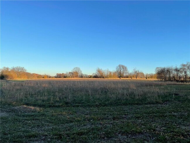
Property Record
9711 Farrar Rd, Bentonville, AR 72713

NEARBY LISTINGS FOR SALE OR LEASE
Property Detail
9711 Farrar Rd
Fayetteville-Springdale-Rogers, AR
Rural
18-08132-000
TRACT 5 OF A TRACT SPLIT SURVEY FILED FOR RECORD MAY 5, 2022 IN/AS INSTRUMENT NO. L202230311 AND CORRECTION SURVEY FILED MARCH 31, 2023 IN/AS INSTRUMENT NO. L202315308, BEING PART OF THE NORTH HALF OF THE SOUTHEAST QUARTER OF THE SOUTHEAST QUARTER OF
Residentialacreage
Benton
X
Arkansas
05007C0265K
4 AC
2025
Outlying Benton County
2025
Fayetteville/Springdale/Rogers
020604
DEMOGRAPHICS near 9711 Farrar Rd
1 Mile
3 Mile
5 Mile
2024 Total Population
816
13,182
44,401
2029 Population
968
15,632
52,584
Pop Growth 2024-2029
+ 18.63%
+ 18.59%
+ 18.43%
Average Age
35
35
35
2024 Total Households
270
4,437
15,305
HH Growth 2024-2029
+ 18.52%
+ 18.55%
+ 18.48%
Median Household Inc
$121,195
$134,722
$127,905
Avg Household Size
3.00
2.90
2.90
2024 Avg HH Vehicles
2.00
2.00
2.00
Median Home Value
$313,636
$346,219
$346,641
Median Year Built
2010
2010
2010
Nearby Places
Map Layers
Map Styles
 Street
 Aerial
- Restaurants
- Banks
- Shops
- Fitness
- Groceries
PUBLIC TRANSPORTATION
AIRPORT
Northwest Arkansas Ntl
DRIVE
WALK
Distance
Northwest Arkansas Ntl
15 min
5.8 mi
Freight Ports
Tulsa Port of Inola
DRIVE
WALK
Distance
Tulsa Port of Inola
108 min
88.8 mi
SALE & LEASE HISTORY
LISTING DATE
SALE/LEASE

Nov 30, 2021
For Sale
Nearby Properties
Address
Land Use
TOTAL SIZE
Lot Size
Zoning
Address
Land Use
TOTAL SIZE
Lot Size
Zoning
43,352 SF
14.68 AC
Address
Land Use
TOTAL SIZE
Lot Size
Zoning
11,853 SF
11.40 AC
Address
Land Use
TOTAL SIZE
Lot Size
Zoning
7,606 SF
1.69 AC
Address
Land Use
TOTAL SIZE
Lot Size
Zoning
8,815 SF
5.35 AC
Address
Land Use
TOTAL SIZE
Lot Size
Zoning
37,500 SF
3.26 AC
Address
Land Use
TOTAL SIZE
Lot Size
Zoning
7,520 SF
87.27 AC
Address
Land Use
TOTAL SIZE
Lot Size
Zoning
9,950 SF
7.56 AC
Address
Land Use
TOTAL SIZE
Lot Size
Zoning
24,000 SF
15.24 AC
Address
Land Use
TOTAL SIZE
Lot Size
Zoning
3,158 SF
0.23 AC
Address
Land Use
TOTAL SIZE
Lot Size
Zoning
21,129 SF
3 AC
Address
Land Use
TOTAL SIZE
Lot Size
Zoning
9,863 SF
1.44 AC
Address
Land Use
TOTAL SIZE
Lot Size
Zoning
3,535 SF
1.92 AC
Address
Land Use
TOTAL SIZE
Lot Size
Zoning
3,580 SF
1.91 AC
Address
Land Use
TOTAL SIZE
Lot Size
Zoning
297 SF
11.79 AC
Address
Land Use
TOTAL SIZE
Lot Size
Zoning
9,397 SF
3.30 AC
Address
Land Use
TOTAL SIZE
Lot Size
Zoning
3,988 SF
1 AC
Address
Land Use
TOTAL SIZE
Lot Size
Zoning
13,229 SF
6.71 AC
Address
Land Use
TOTAL SIZE
Lot Size
Zoning
1,924 SF
4.20 AC
Address
Land Use
TOTAL SIZE
Lot Size
Zoning
2,784 SF
0.06 AC
Address
Land Use
TOTAL SIZE
Lot Size
Zoning
7,776 SF
5.45 AC
Address
Land Use
TOTAL SIZE
Lot Size
Zoning
7,020 SF
2.26 AC
Address
Land Use
TOTAL SIZE
Lot Size
Zoning
30,000 SF
10.83 AC
Address
Land Use
TOTAL SIZE
Lot Size
Zoning
15,754 SF
13.64 AC
Address
Land Use
TOTAL SIZE
Lot Size
Zoning
11,440 SF
1.26 AC
Address
Land Use
TOTAL SIZE
Lot Size
Zoning
3,200 SF
6.01 AC
Address
Land Use
TOTAL SIZE
Lot Size
Zoning
14,069 SF
2.25 AC
Address
Land Use
TOTAL SIZE
Lot Size
Zoning
12,660 SF
21.73 AC
Address
Land Use
TOTAL SIZE
Lot Size
Zoning
5.78 AC
Address
Land Use
TOTAL SIZE
Lot Size
Zoning
4,000 SF
5.36 AC
Address
Land Use
TOTAL SIZE
Lot Size
Zoning
8,042 SF
3 AC
The World's #1 Commercial Real Estate Marketplace
Connect with us
© 2026 CoStar Group
The information above has been obtained from sources believed reliable. While we do not doubt its accuracy we have not verified it and make no guarantee, warranty or representation about it. It is your responsibility to independently confirm its accuracy and completeness. Any projections, opinions, assumptions, or estimates used are for example only and do not represent the current or future performance of the property. The value of this transaction to you depends on tax and other factors which should be evaluated by your tax, financial, and legal advisors. You and your advisors should conduct a careful, independent investigation of the property to determine to your satisfaction the suitability of the property for your needs.