Property Record
2222 Farrs Bridge Rd, Easley, SC 29640
NEARBY LISTINGS FOR SALE OR LEASE
-
-
View all Easley listings for sale on LoopNet.com
Property Detail
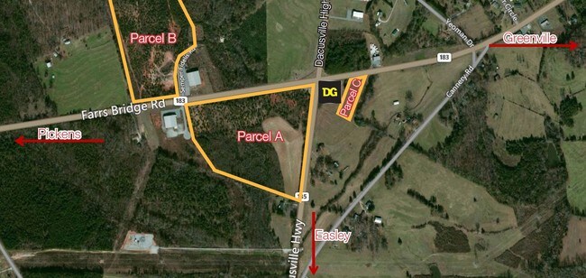
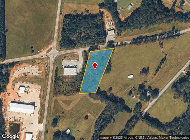
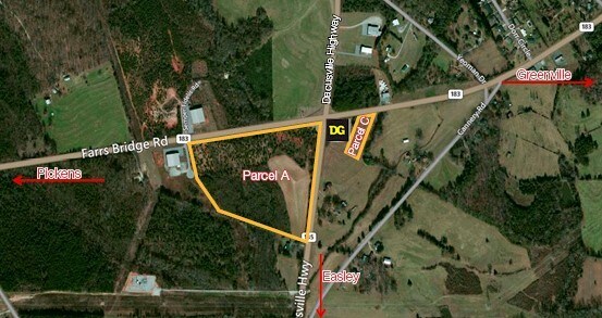
2222 Farrs Bridge Rd
Greenville-Anderson-Mauldin, SC
Boundary Survey For Walter Turner Robins
5111-00-93-5283
E/SIDE HWY 135 N S/SIDE HWY 183 FARR BRIDGE RD LOT 3 PLAT 600/45 PLAT 600/261
Vacantlandnec
Pickens
X
South Carolina
45045C0300E
3
2025
1.69 AC
2024
Outlying Pickens County
010601
Greenville/Spartanburg
DEMOGRAPHICS near 2222 Farrs Bridge Rd
1 Mile
3 Mile
5 Mile
2024 Total Population
545
8,232
33,800
2029 Population
567
8,634
35,453
Pop Growth 2024-2029
+ 4.04%
+ 4.88%
+ 4.89%
Average Age
42
42
41
2024 Total Households
205
3,241
13,875
HH Growth 2024-2029
+ 4.39%
+ 5.00%
+ 4.99%
Median Household Inc
$70,588
$57,124
$50,773
Avg Household Size
2.60
2.50
2.40
2024 Avg HH Vehicles
2.00
2.00
2.00
Median Home Value
$254,615
$198,012
$169,866
Median Year Built
1990
1989
1985
Nearby Places
Map Layers
Map Styles
 Street
 Aerial
- Restaurants
- Banks
- Shops
- Fitness
- Groceries
PUBLIC TRANSPORTATION
AIRPORT
Greenville Spartanburg International
DRIVE
WALK
Distance
Greenville Spartanburg International
44 min
27.1 mi
Freight Ports
North Charleston Terminal
DRIVE
WALK
Distance
North Charleston Terminal
252 min
217.7 mi
SALE & LEASE HISTORY
LISTING DATE
SALE/LEASE

Sep 24, 2016
For Sale
Nearby Properties
Address
Land Use
TOTAL SIZE
Lot Size
Zoning
Address
Land Use
TOTAL SIZE
Lot Size
Zoning
52,710 SF
9.75 AC
Address
Land Use
TOTAL SIZE
Lot Size
Zoning
29,695 SF
4 AC
Address
Land Use
TOTAL SIZE
Lot Size
Zoning
4,450 SF
1.28 AC
MED MEDICA
Address
Land Use
TOTAL SIZE
Lot Size
Zoning
18,240 SF
4 AC
Address
Land Use
TOTAL SIZE
Lot Size
Zoning
16,800 SF
8.85 AC
GENERAL RE
Address
Land Use
TOTAL SIZE
Lot Size
Zoning
11,359 SF
7.74 AC
Address
Land Use
TOTAL SIZE
Lot Size
Zoning
17.21 AC
R 10 ONE F
Address
Land Use
TOTAL SIZE
Lot Size
Zoning
40.30 AC
R 10 ONE F
Address
Land Use
TOTAL SIZE
Lot Size
Zoning
19.53 AC
Address
Land Use
TOTAL SIZE
Lot Size
Zoning
22.20 AC
Address
Land Use
TOTAL SIZE
Lot Size
Zoning
Address
Land Use
TOTAL SIZE
Lot Size
Zoning
8.36 AC
Address
Land Use
TOTAL SIZE
Lot Size
Zoning
5,560 SF
12 AC
R10
Address
Land Use
TOTAL SIZE
Lot Size
Zoning
9.54 AC
Address
Land Use
TOTAL SIZE
Lot Size
Zoning
258,771 SF
58 AC
Address
Land Use
TOTAL SIZE
Lot Size
Zoning
32,117 SF
8.03 AC
Address
Land Use
TOTAL SIZE
Lot Size
Zoning
1.23 AC
MED MEDICA
Address
Land Use
TOTAL SIZE
Lot Size
Zoning
8.85 AC
Address
Land Use
TOTAL SIZE
Lot Size
Zoning
8.79 AC
Address
Land Use
TOTAL SIZE
Lot Size
Zoning
6.55 AC
Address
Land Use
TOTAL SIZE
Lot Size
Zoning
2,760 SF
102 AC
Address
Land Use
TOTAL SIZE
Lot Size
Zoning
9,177 SF
2.80 AC
Address
Land Use
TOTAL SIZE
Lot Size
Zoning
14,166 SF
0.92 AC
MED MEDICA
Address
Land Use
TOTAL SIZE
Lot Size
Zoning
1,400 SF
3.94 AC
Address
Land Use
TOTAL SIZE
Lot Size
Zoning
14,166 SF
0.95 AC
MED MEDICA
Address
Land Use
TOTAL SIZE
Lot Size
Zoning
9,228 SF
1.83 AC
MED MEDICA
Address
Land Use
TOTAL SIZE
Lot Size
Zoning
6.30 AC
Address
Land Use
TOTAL SIZE
Lot Size
Zoning
5,846 SF
1.39 AC
MED MEDICA
Address
Land Use
TOTAL SIZE
Lot Size
Zoning
750 SF
2.86 AC
The World's #1 Commercial Real Estate Marketplace
Connect with us
© 2025 CoStar Group
The information above has been obtained from sources believed reliable. While we do not doubt its accuracy we have not verified it and make no guarantee, warranty or representation about it. It is your responsibility to independently confirm its accuracy and completeness. Any projections, opinions, assumptions, or estimates used are for example only and do not represent the current or future performance of the property. The value of this transaction to you depends on tax and other factors which should be evaluated by your tax, financial, and legal advisors. You and your advisors should conduct a careful, independent investigation of the property to determine to your satisfaction the suitability of the property for your needs.