Property Record
Fennel Rd, Tanner, AL 35671
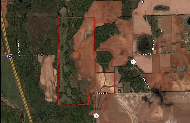
This Property Is For Sale
Property Detail
Fennel Rd
Huntsville, AL
BEG NW COR OF NE TH S 1180 E 1320 N 1180 W 1320 TO POB IN SEC 24 4 4N
16-06-13-0-000-003.002
LIMESTONE
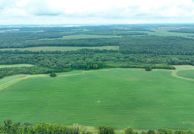
Agriculturalland
Alabama
A Areas with a 1% annual chance of flooding and a 26% chance of flooding over the life of a 30-year mortgage.
23 AC
2025
Outlying Limestone County
2025
Huntsville
021101
NEARBY LISTINGS FOR SALE OR LEASE
DEMOGRAPHICS near Fennel Rd
1 mile
3 mile
5 mile
2025 Total Population
56
248
8,103
2030 Population
64
282
9,164
Pop Growth 2025-2030
+ 14.29%
+ 13.71%
+ 13.09%
Average Age
37
38
39
2025 Total Households
20
96
3,133
HH Growth 2025-2030
+ 15.00%
+ 14.58%
+ 13.31%
Median Household Inc
$160,714
$99,073
$108,436
Avg Household Size
2.70
2.60
2.60
2025 Avg HH Vehicles
3.00
3.00
2.00
Median Home Value
$499,999
$463,636
$388,361
Median Year Built
2010
2010
2009
Nearby Places
Map Layers
Map Styles
 Street
 Aerial
Transit
 Traffic
 Biking
Places
Listings with unknown addresses are not visible on the map
- Restaurants
- Banks
- Shops
- Fitness
- Groceries
PUBLIC TRANSPORTATION
AIRPORT
Huntsville International-Carl T Jones Field
Drive
Walk
Distance
Huntsville International-Carl T Jones Field
30 min
14.3 mi
Freight Ports
Port of Mobile
Drive
Walk
Distance
Port of Mobile
385 min
343.3 mi
Nearby Properties
Address
Land Use
TOTAL SIZE
Lot Size
Zoning
Address
Land Use
TOTAL SIZE
Lot Size
Zoning
290,160 SF
17.37 AC
Address
Land Use
TOTAL SIZE
Lot Size
Zoning
55,196 SF
21.21 AC
Address
Land Use
TOTAL SIZE
Lot Size
Zoning
2,156 SF
107 AC
Address
Land Use
TOTAL SIZE
Lot Size
Zoning
41,600 SF
13.86 AC
Address
Land Use
TOTAL SIZE
Lot Size
Zoning
27,360 SF
4.80 AC
Address
Land Use
TOTAL SIZE
Lot Size
Zoning
196.30 AC
Address
Land Use
TOTAL SIZE
Lot Size
Zoning
2,400 SF
19.86 AC
Address
Land Use
TOTAL SIZE
Lot Size
Zoning
3,700 SF
1 AC
Address
Land Use
TOTAL SIZE
Lot Size
Zoning
1,560 SF
17.83 AC
Address
Land Use
TOTAL SIZE
Lot Size
Zoning
5,000 SF
1.30 AC
Address
Land Use
TOTAL SIZE
Lot Size
Zoning
119 AC
Address
Land Use
TOTAL SIZE
Lot Size
Zoning
322 AC
Address
Land Use
TOTAL SIZE
Lot Size
Zoning
110 AC
Address
Land Use
TOTAL SIZE
Lot Size
Zoning
Address
Land Use
TOTAL SIZE
Lot Size
Zoning
10,360 SF
0.75 AC
Address
Land Use
TOTAL SIZE
Lot Size
Zoning
Address
Land Use
TOTAL SIZE
Lot Size
Zoning
81.22 AC
Address
Land Use
TOTAL SIZE
Lot Size
Zoning
368.49 AC
Address
Land Use
TOTAL SIZE
Lot Size
Zoning
3,394 SF
2.70 AC
Address
Land Use
TOTAL SIZE
Lot Size
Zoning
Address
Land Use
TOTAL SIZE
Lot Size
Zoning
39 AC
Address
Land Use
TOTAL SIZE
Lot Size
Zoning
840 SF
570 AC
Address
Land Use
TOTAL SIZE
Lot Size
Zoning
138.50 AC
Address
Land Use
TOTAL SIZE
Lot Size
Zoning
2,965 SF
19.70 AC
Address
Land Use
TOTAL SIZE
Lot Size
Zoning
210 AC
Address
Land Use
TOTAL SIZE
Lot Size
Zoning
1,040 SF
0.18 AC
Address
Land Use
TOTAL SIZE
Lot Size
Zoning
3.57 AC
Address
Land Use
TOTAL SIZE
Lot Size
Zoning
3,300 SF
0.18 AC
Address
Land Use
TOTAL SIZE
Lot Size
Zoning
Address
Land Use
TOTAL SIZE
Lot Size
Zoning
The World's #1 Commercial Real Estate Marketplace
Connect with us
© 2026 CoStar Group
The information above has been obtained from sources believed reliable. While we do not doubt its accuracy we have not verified it and make no guarantee, warranty or representation about it. It is your responsibility to independently confirm its accuracy and completeness. Any projections, opinions, assumptions, or estimates used are for example only and do not represent the current or future performance of the property. The value of this transaction to you depends on tax and other factors which should be evaluated by your tax, financial, and legal advisors. You and your advisors should conduct a careful, independent investigation of the property to determine to your satisfaction the suitability of the property for your needs.