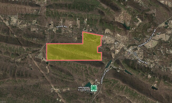
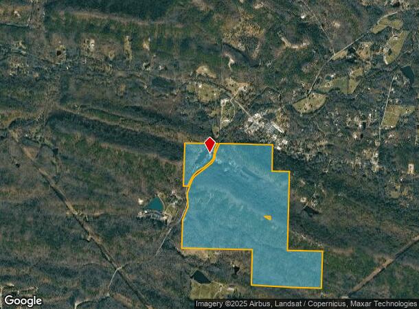
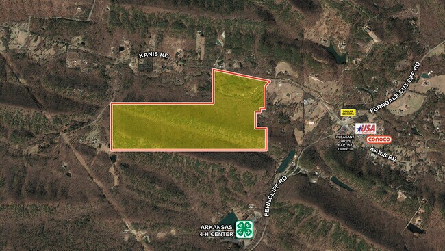
Property Record
Ferncliff Rd, Little Rock, AR 72223
NEARBY LISTINGS FOR SALE OR LEASE
-
-
View all Little Rock listings for sale on LoopNet.com
Property Detail
Ferncliff Rd
63R-036-00-018-00
PT SEC 36 W1/2NE EXC TR660E & W BY 990 N&S IN NE CR N1/2SW SE EXC NE S & ALL NW EXC BG NW CR SW NW N89* E 191 34 TO PT IN CLN FERNDALE CUT- OFF RDS18*W AL C SD RD 277 S7* E AL RD 484.05S20*W444 TO PT CTR FERN DALE CUT-OFF RD INTERSECTS WITH WLN. SW N
Fratsororityhouse
Pulaski
A
Arkansas
05119C0290G
418.88 AC
2025
Outlying Pulaski County
2025
Little Rock/N Little Rock
004229
Little Rock-North Little Rock-Conway, AR
9,596 SF
DEMOGRAPHICS near Ferncliff Rd
1 Mile
3 Mile
5 Mile
2024 Total Population
324
2,799
14,015
2029 Population
330
2,879
14,384
Pop Growth 2024-2029
+ 1.85%
+ 2.86%
+ 2.63%
Average Age
44
44
43
2024 Total Households
134
1,127
5,596
HH Growth 2024-2029
+ 1.49%
+ 2.75%
+ 2.48%
Median Household Inc
$110,326
$105,000
$116,017
Avg Household Size
2.40
2.50
2.50
2024 Avg HH Vehicles
3.00
2.00
2.00
Median Home Value
$413,333
$390,565
$390,009
Median Year Built
1995
1994
2001
Nearby Places
Map Layers
Map Styles
 Street
 Aerial
- Restaurants
- Banks
- Shops
- Fitness
- Groceries
PUBLIC TRANSPORTATION
AIRPORT
Bill and Hillary Clinton Ntl/Adams Field
DRIVE
WALK
Distance
Bill and Hillary Clinton Ntl/Adams Field
40 min
22.2 mi
Freight Ports
Port of Shreveport
DRIVE
WALK
Distance
Port of Shreveport
259 min
226.2 mi
SALE & LEASE HISTORY
LISTING DATE
SALE/LEASE

May 20, 2020
For Sale
Nearby Properties
Address
Land Use
TOTAL SIZE
Lot Size
Zoning
Address
Land Use
TOTAL SIZE
Lot Size
Zoning
32,051 SF
245.44 AC
Address
Land Use
TOTAL SIZE
Lot Size
Zoning
12,113 SF
5.28 AC
Address
Land Use
TOTAL SIZE
Lot Size
Zoning
15,698 SF
82 AC
Address
Land Use
TOTAL SIZE
Lot Size
Zoning
7,877 SF
10.10 AC
Address
Land Use
TOTAL SIZE
Lot Size
Zoning
12,412 SF
1.22 AC
Address
Land Use
TOTAL SIZE
Lot Size
Zoning
4,480 SF
3.76 AC
Address
Land Use
TOTAL SIZE
Lot Size
Zoning
1,840 SF
2.79 AC
Address
Land Use
TOTAL SIZE
Lot Size
Zoning
9,220 SF
1.87 AC
Address
Land Use
TOTAL SIZE
Lot Size
Zoning
2,960 SF
0.98 AC
Address
Land Use
TOTAL SIZE
Lot Size
Zoning
4,000 SF
1.39 AC
Address
Land Use
TOTAL SIZE
Lot Size
Zoning
4,860 SF
19.85 AC
Address
Land Use
TOTAL SIZE
Lot Size
Zoning
6,000 SF
3.02 AC
Address
Land Use
TOTAL SIZE
Lot Size
Zoning
7,932 SF
30.41 AC
Address
Land Use
TOTAL SIZE
Lot Size
Zoning
6,759 SF
4.10 AC
Address
Land Use
TOTAL SIZE
Lot Size
Zoning
1,733 SF
22.54 AC
Address
Land Use
TOTAL SIZE
Lot Size
Zoning
Address
Land Use
TOTAL SIZE
Lot Size
Zoning
2,340 SF
1.07 AC
Address
Land Use
TOTAL SIZE
Lot Size
Zoning
12,600 SF
1.03 AC
Address
Land Use
TOTAL SIZE
Lot Size
Zoning
8.93 AC
Address
Land Use
TOTAL SIZE
Lot Size
Zoning
1,855 SF
0.82 AC
Address
Land Use
TOTAL SIZE
Lot Size
Zoning
6,174 SF
0.89 AC
Address
Land Use
TOTAL SIZE
Lot Size
Zoning
2,089 SF
3.98 AC
Address
Land Use
TOTAL SIZE
Lot Size
Zoning
2,051 SF
0.82 AC
Address
Land Use
TOTAL SIZE
Lot Size
Zoning
6.42 AC
Address
Land Use
TOTAL SIZE
Lot Size
Zoning
Address
Land Use
TOTAL SIZE
Lot Size
Zoning
5,187 SF
0.86 AC
Address
Land Use
TOTAL SIZE
Lot Size
Zoning
Address
Land Use
TOTAL SIZE
Lot Size
Zoning
7.07 AC
Address
Land Use
TOTAL SIZE
Lot Size
Zoning
6.97 AC
The World's #1 Commercial Real Estate Marketplace
Connect with us
© 2026 CoStar Group
The information above has been obtained from sources believed reliable. While we do not doubt its accuracy we have not verified it and make no guarantee, warranty or representation about it. It is your responsibility to independently confirm its accuracy and completeness. Any projections, opinions, assumptions, or estimates used are for example only and do not represent the current or future performance of the property. The value of this transaction to you depends on tax and other factors which should be evaluated by your tax, financial, and legal advisors. You and your advisors should conduct a careful, independent investigation of the property to determine to your satisfaction the suitability of the property for your needs.