Property Record
Ferry Rd, Warrenville, IL 60555
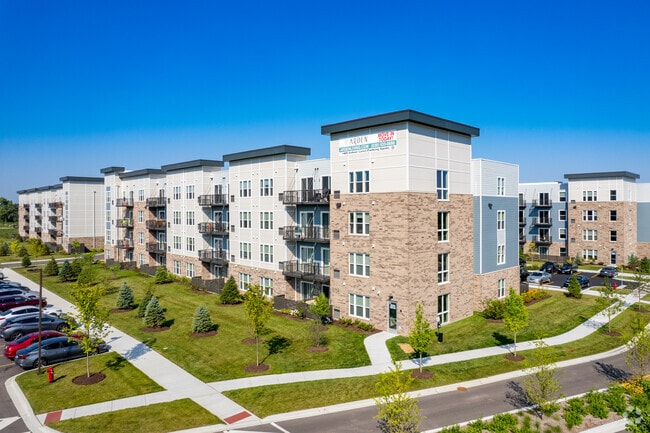

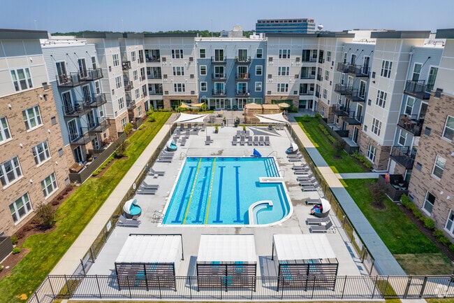
Property Detail
Ferry Rd
Chicago
CANTERA SUB AREA C2 LOTS 2 AND 3 RESUB ALL
Chicago-Naperville-Elgin, IL-IN
DUPAGE
07-02-201-022
Illinois
Commercialnec
2,3
2024
17.59 AC
2024
Cantera
841603
NEARBY LISTINGS FOR SALE OR LEASE
-
-
View all Warrenville listings for sale on LoopNet.com
DEMOGRAPHICS near Ferry Rd
1 mile
3 mile
5 mile
2025 Total Population
4,527
63,017
193,689
2030 Population
4,638
64,063
196,475
Pop Growth 2025-2030
+ 2.45%
+ 1.66%
+ 1.44%
Average Age
44
40
40
2025 Total Households
1,918
25,084
73,418
HH Growth 2025-2030
+ 2.61%
+ 1.79%
+ 1.51%
Median Household Inc
$109,577
$108,125
$116,620
Avg Household Size
2.30
2.40
2.50
2025 Avg HH Vehicles
2.00
2.00
2.00
Median Home Value
$403,865
$428,634
$437,573
Median Year Built
1988
1983
1983
Nearby Places
Map Layers
Map Styles
 Street
 Aerial
Layers
 Traffic
 Biking
Places
Listings with unknown addresses are not visible on the map
- Restaurants
- Banks
- Shops
- Fitness
- Groceries
PUBLIC TRANSPORTATION
COMMUTER RAIL
Naperville Station (Burlington Northern-Santa Fe Railway Line - Northeast Illinois Regional Commuter Railroad (Metra))
Drive
Walk
Distance
Naperville Station (Burlington Northern-Santa Fe Railway Line - Northeast Illinois Regional Commuter Railroad (Metra))
8 min
3.5 mi
Route 59 Station (Burlington Northern-Santa Fe Railway Line - Northeast Illinois Regional Commuter Railroad (Metra))
Drive
Walk
Distance
Route 59 Station (Burlington Northern-Santa Fe Railway Line - Northeast Illinois Regional Commuter Railroad (Metra))
9 min
4.1 mi
AIRPORT
Chicago Midway International
Drive
Walk
Distance
Chicago Midway International
41 min
27.1 mi
Chicago O'Hare International
Drive
Walk
Distance
Chicago O'Hare International
41 min
28.0 mi
Freight Ports
Port Milwaukee
Drive
Walk
Distance
Port Milwaukee
122 min
99.7 mi
Nearby Properties
Address
Land Use
TOTAL SIZE
Lot Size
Zoning
Address
Land Use
TOTAL SIZE
Lot Size
Zoning
20.60 AC
Address
Land Use
TOTAL SIZE
Lot Size
Zoning
47.26 AC
Address
Land Use
TOTAL SIZE
Lot Size
Zoning
Address
Land Use
TOTAL SIZE
Lot Size
Zoning
31.66 AC
C
Address
Land Use
TOTAL SIZE
Lot Size
Zoning
17.70 AC
Address
Land Use
TOTAL SIZE
Lot Size
Zoning
Address
Land Use
TOTAL SIZE
Lot Size
Zoning
797,399 SF
52.38 AC
C
Address
Land Use
TOTAL SIZE
Lot Size
Zoning
272,400 SF
20.94 AC
C
Address
Land Use
TOTAL SIZE
Lot Size
Zoning
315,328 SF
5.06 AC
Address
Land Use
TOTAL SIZE
Lot Size
Zoning
25 AC
M
Address
Land Use
TOTAL SIZE
Lot Size
Zoning
9.18 AC
C
Address
Land Use
TOTAL SIZE
Lot Size
Zoning
15.33 AC
I
Address
Land Use
TOTAL SIZE
Lot Size
Zoning
5.43 AC
Address
Land Use
TOTAL SIZE
Lot Size
Zoning
8.36 AC
C
Address
Land Use
TOTAL SIZE
Lot Size
Zoning
266,118 SF
21.65 AC
C
Address
Land Use
TOTAL SIZE
Lot Size
Zoning
96.92 AC
I
Address
Land Use
TOTAL SIZE
Lot Size
Zoning
1,059,897 SF
122.10 AC
C
Address
Land Use
TOTAL SIZE
Lot Size
Zoning
721,600 SF
34.74 AC
I
Address
Land Use
TOTAL SIZE
Lot Size
Zoning
16.15 AC
M
Address
Land Use
TOTAL SIZE
Lot Size
Zoning
15.61 AC
M
Address
Land Use
TOTAL SIZE
Lot Size
Zoning
31.08 AC
Address
Land Use
TOTAL SIZE
Lot Size
Zoning
Address
Land Use
TOTAL SIZE
Lot Size
Zoning
239,418 SF
21.27 AC
C
Address
Land Use
TOTAL SIZE
Lot Size
Zoning
505,720 SF
27.67 AC
Address
Land Use
TOTAL SIZE
Lot Size
Zoning
6.59 AC
Address
Land Use
TOTAL SIZE
Lot Size
Zoning
16.26 AC
C
Address
Land Use
TOTAL SIZE
Lot Size
Zoning
522,457 SF
29.33 AC
I
Address
Land Use
TOTAL SIZE
Lot Size
Zoning
23.45 AC
Address
Land Use
TOTAL SIZE
Lot Size
Zoning
16.86 AC
C
The World's #1 Commercial Real Estate Marketplace
Connect with us
© 2026 CoStar Group
The information above has been obtained from sources believed reliable. While we do not doubt its accuracy we have not verified it and make no guarantee, warranty or representation about it. It is your responsibility to independently confirm its accuracy and completeness. Any projections, opinions, assumptions, or estimates used are for example only and do not represent the current or future performance of the property. The value of this transaction to you depends on tax and other factors which should be evaluated by your tax, financial, and legal advisors. You and your advisors should conduct a careful, independent investigation of the property to determine to your satisfaction the suitability of the property for your needs.