Property Record
Flat Crk, Barnegat, NJ 08005

Property Detail
Flat Crk
Lakewood-New Brunswick, NJ
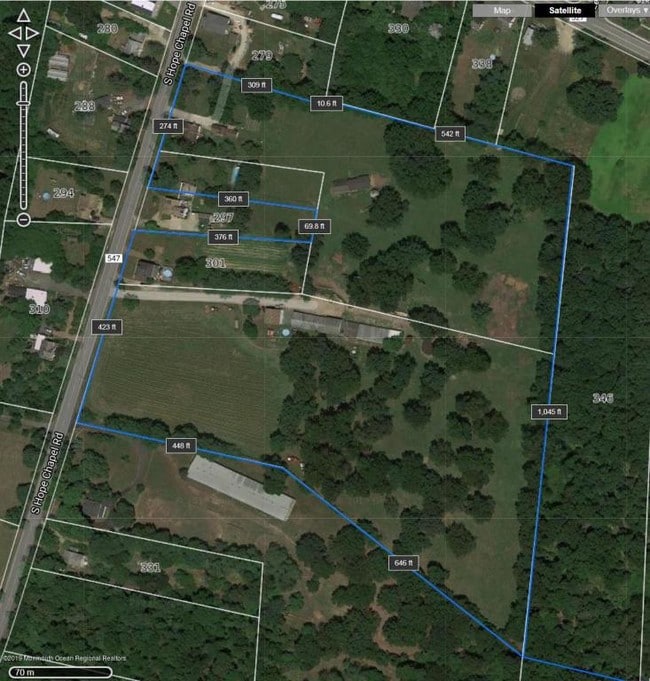
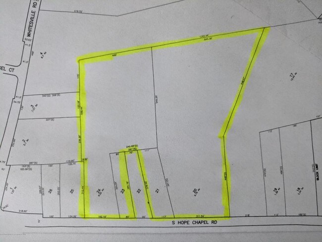
40.0 AC BIRD SANCTUARY
01-00267-0000-00020
OCEAN
Governmentalpublicusegeneral
New Jersey
PW
20
B and X Area of moderate flood hazard, usually the area between the limits of the 100-year and 500-year floods.
40 AC
0
Ocean County
2025
Northern New Jersey
734002
NEARBY LISTINGS FOR SALE OR LEASE
-
-
View all Barnegat listings for sale on LoopNet.com
DEMOGRAPHICS near Flat Crk
1 mile
3 mile
5 mile
2025 Total Population
1,149
58,071
177,657
2030 Population
1,153
58,374
177,229
Pop Growth 2025-2030
+ 0.35%
+ 0.52%
(0.24%)
Average Age
31
33
33
2025 Total Households
302
16,273
50,110
HH Growth 2025-2030
(0.66%)
(0.18%)
(1.08%)
Median Household Inc
$114,843
$82,707
$72,758
Avg Household Size
3.40
3.20
3.20
2025 Avg HH Vehicles
2.00
2.00
2.00
Median Home Value
$515,766
$440,577
$411,773
Median Year Built
1981
1995
1988
Nearby Places
Map Layers
Map Styles
 Street
 Aerial
Transit
 Traffic
 Biking
Places
Listings with unknown addresses are not visible on the map
- Restaurants
- Banks
- Shops
- Fitness
- Groceries
PUBLIC TRANSPORTATION
AIRPORT
Atlantic City International
Drive
Walk
Distance
Atlantic City International
71 min
36.7 mi
Freight Ports
Port of Philadelphia
Drive
Walk
Distance
Port of Philadelphia
76 min
56.0 mi
SALE & LEASE HISTORY
LISTING DATE
SALE/LEASE

Sep 05, 2019
For Sale
Nearby Properties
Address
Land Use
TOTAL SIZE
Lot Size
Zoning
Address
Land Use
TOTAL SIZE
Lot Size
Zoning
23.70 AC
BCWD
Address
Land Use
TOTAL SIZE
Lot Size
Zoning
4.85 AC
CPHD
Address
Land Use
TOTAL SIZE
Lot Size
Zoning
398 AC
PW
Address
Land Use
TOTAL SIZE
Lot Size
Zoning
5.14 AC
CPHD
Address
Land Use
TOTAL SIZE
Lot Size
Zoning
58,375 SF
5.46 AC
CPHD
Address
Land Use
TOTAL SIZE
Lot Size
Zoning
6.39 AC
ML-1
Address
Land Use
TOTAL SIZE
Lot Size
Zoning
6.03 AC
MU
Address
Land Use
TOTAL SIZE
Lot Size
Zoning
256 SF
1.61 AC
CM
Address
Land Use
TOTAL SIZE
Lot Size
Zoning
1.42 AC
R10
Address
Land Use
TOTAL SIZE
Lot Size
Zoning
197.50 AC
PW
Address
Land Use
TOTAL SIZE
Lot Size
Zoning
3.90 AC
WD
Address
Land Use
TOTAL SIZE
Lot Size
Zoning
5,912 SF
1.05 AC
TCCV
Address
Land Use
TOTAL SIZE
Lot Size
Zoning
2,152 SF
3.31 AC
CPHD
Address
Land Use
TOTAL SIZE
Lot Size
Zoning
1.43 AC
CPHD
Address
Land Use
TOTAL SIZE
Lot Size
Zoning
89.12 AC
BC
Address
Land Use
TOTAL SIZE
Lot Size
Zoning
1,928 SF
3.67 AC
CM
Address
Land Use
TOTAL SIZE
Lot Size
Zoning
5,594 SF
1.28 AC
R-PB
Address
Land Use
TOTAL SIZE
Lot Size
Zoning
3,758 SF
4 AC
CM
Address
Land Use
TOTAL SIZE
Lot Size
Zoning
19,800 SF
2.52 AC
CPHD
Address
Land Use
TOTAL SIZE
Lot Size
Zoning
15,874 SF
2.39 AC
CPHD
Address
Land Use
TOTAL SIZE
Lot Size
Zoning
9,003 SF
1.38 AC
TCCV
Address
Land Use
TOTAL SIZE
Lot Size
Zoning
4,786 SF
6.82 AC
CM
Address
Land Use
TOTAL SIZE
Lot Size
Zoning
5,400 SF
1.56 AC
CVH
Address
Land Use
TOTAL SIZE
Lot Size
Zoning
84.30 AC
PW
Address
Land Use
TOTAL SIZE
Lot Size
Zoning
1,134 SF
1.26 AC
CM
Address
Land Use
TOTAL SIZE
Lot Size
Zoning
4,170 SF
1.10 AC
CPHD
Address
Land Use
TOTAL SIZE
Lot Size
Zoning
2,922 SF
0.37 AC
R6
Address
Land Use
TOTAL SIZE
Lot Size
Zoning
1,818 SF
3.03 AC
CPHD
Address
Land Use
TOTAL SIZE
Lot Size
Zoning
0.26 AC
R6
Address
Land Use
TOTAL SIZE
Lot Size
Zoning
5,505 SF
0.34 AC
CPHD
The World's #1 Commercial Real Estate Marketplace
Connect with us
© 2026 CoStar Group
The information above has been obtained from sources believed reliable. While we do not doubt its accuracy we have not verified it and make no guarantee, warranty or representation about it. It is your responsibility to independently confirm its accuracy and completeness. Any projections, opinions, assumptions, or estimates used are for example only and do not represent the current or future performance of the property. The value of this transaction to you depends on tax and other factors which should be evaluated by your tax, financial, and legal advisors. You and your advisors should conduct a careful, independent investigation of the property to determine to your satisfaction the suitability of the property for your needs.