Property Record
Flint Morgan Rd, Mars Hill, NC 28754
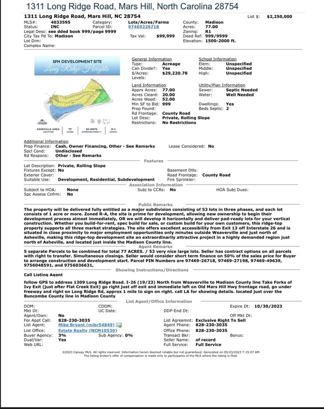
Property Detail
Flint Morgan Rd
9746-94-9639
MADISON
Realpropertynec
North Carolina
R-A
8 AC
B and X Area of moderate flood hazard, usually the area between the limits of the 100-year and 500-year floods.
Madison County
2024
Asheville
2024
Asheville, NC
010700
NEARBY LISTINGS FOR SALE OR LEASE
-
-
View all Mars Hill listings for sale on LoopNet.com
DEMOGRAPHICS near Flint Morgan Rd
1 mile
3 mile
5 mile
2025 Total Population
502
8,137
16,252
2030 Population
525
8,444
16,819
Pop Growth 2025-2030
+ 4.58%
+ 3.77%
+ 3.49%
Average Age
41
43
43
2025 Total Households
173
3,081
6,321
HH Growth 2025-2030
+ 4.05%
+ 3.47%
+ 3.21%
Median Household Inc
$84,677
$74,026
$74,217
Avg Household Size
2.30
2.40
2.40
2025 Avg HH Vehicles
3.00
2.00
2.00
Median Home Value
$388,635
$369,156
$374,077
Median Year Built
1991
1991
1992
Nearby Places
Map Layers
Map Styles
 Street
 Aerial
Transit
 Traffic
 Biking
Places
Listings with unknown addresses are not visible on the map
- Restaurants
- Banks
- Shops
- Fitness
- Groceries
PUBLIC TRANSPORTATION
AIRPORT
Asheville Regional
Drive
Walk
Distance
Asheville Regional
42 min
29.9 mi
Freight Ports
North Charleston Terminal
Drive
Walk
Distance
North Charleston Terminal
313 min
273.6 mi
SALE & LEASE HISTORY
LISTING DATE
SALE/LEASE

May 23, 2023
For Sale
Nearby Properties
Address
Land Use
TOTAL SIZE
Lot Size
Zoning
Address
Land Use
TOTAL SIZE
Lot Size
Zoning
1,536 SF
27.44 AC
R-A
Address
Land Use
TOTAL SIZE
Lot Size
Zoning
86,141 SF
10.20 AC
R-A
Address
Land Use
TOTAL SIZE
Lot Size
Zoning
19,798 SF
8.07 AC
OU
Address
Land Use
TOTAL SIZE
Lot Size
Zoning
24,666 SF
0.50 AC
R-1
Address
Land Use
TOTAL SIZE
Lot Size
Zoning
15,864 SF
2.26 AC
R-A
Address
Land Use
TOTAL SIZE
Lot Size
Zoning
29,968 SF
6.94 AC
R-A
Address
Land Use
TOTAL SIZE
Lot Size
Zoning
13,098 SF
73.40 AC
OU
Address
Land Use
TOTAL SIZE
Lot Size
Zoning
28,642 SF
1.29 AC
R-A
Address
Land Use
TOTAL SIZE
Lot Size
Zoning
8,957 SF
68.33 AC
OU
Address
Land Use
TOTAL SIZE
Lot Size
Zoning
11,878 SF
77.09 AC
OU
Address
Land Use
TOTAL SIZE
Lot Size
Zoning
6,381 SF
5.20 AC
R-A
Address
Land Use
TOTAL SIZE
Lot Size
Zoning
16,078 SF
1.03 AC
R-A
Address
Land Use
TOTAL SIZE
Lot Size
Zoning
18,258 SF
3.91 AC
OU
Address
Land Use
TOTAL SIZE
Lot Size
Zoning
4,939 SF
2.16 AC
R-A
Address
Land Use
TOTAL SIZE
Lot Size
Zoning
57.16 AC
R-A
Address
Land Use
TOTAL SIZE
Lot Size
Zoning
231 SF
7.12 AC
R-A
Address
Land Use
TOTAL SIZE
Lot Size
Zoning
14,916 SF
0.96 AC
R-A
Address
Land Use
TOTAL SIZE
Lot Size
Zoning
13,466 SF
4 AC
R-A
Address
Land Use
TOTAL SIZE
Lot Size
Zoning
22,863 SF
0.80 AC
R-A
Address
Land Use
TOTAL SIZE
Lot Size
Zoning
1,170 SF
186.89 AC
R-A
Address
Land Use
TOTAL SIZE
Lot Size
Zoning
6,955 SF
0.74 AC
R-A
Address
Land Use
TOTAL SIZE
Lot Size
Zoning
5,376 SF
2.14 AC
R-A
Address
Land Use
TOTAL SIZE
Lot Size
Zoning
4,300 SF
6.20 AC
OU
Address
Land Use
TOTAL SIZE
Lot Size
Zoning
920 SF
18.24 AC
R-1
Address
Land Use
TOTAL SIZE
Lot Size
Zoning
5,400 SF
1.69 AC
R-A
Address
Land Use
TOTAL SIZE
Lot Size
Zoning
6,151 SF
31.17 AC
OU
Address
Land Use
TOTAL SIZE
Lot Size
Zoning
1,860 SF
3.05 AC
R-A
Address
Land Use
TOTAL SIZE
Lot Size
Zoning
4,044 SF
3.96 AC
R-A
Address
Land Use
TOTAL SIZE
Lot Size
Zoning
2,114 SF
223.10 AC
OU
The World's #1 Commercial Real Estate Marketplace
Connect with us
© 2026 CoStar Group
The information above has been obtained from sources believed reliable. While we do not doubt its accuracy we have not verified it and make no guarantee, warranty or representation about it. It is your responsibility to independently confirm its accuracy and completeness. Any projections, opinions, assumptions, or estimates used are for example only and do not represent the current or future performance of the property. The value of this transaction to you depends on tax and other factors which should be evaluated by your tax, financial, and legal advisors. You and your advisors should conduct a careful, independent investigation of the property to determine to your satisfaction the suitability of the property for your needs.