Property Record
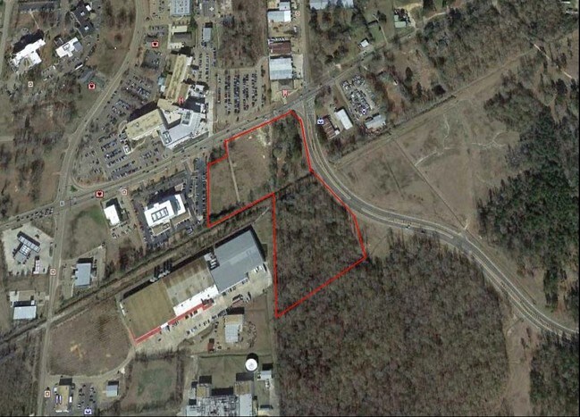
185 Medical Pkwy, Flowood, MS 39232

Property Detail
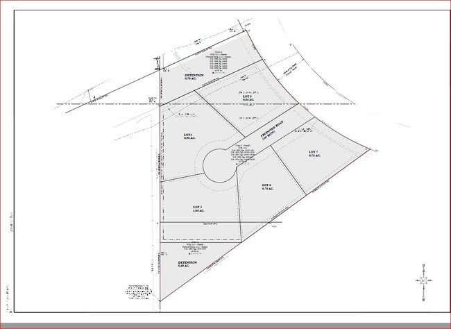
185 Medical Pkwy
F10E-000011-00000
APPROX 3.39 AC IN NW4 NW4 N OF RR EXEMPT FROM CITY & COUNTY- 1ST 5 YEARS EXPIRES 12/2028 2ND 5 YEARS EXPIRES 12/2033 S OF FLO
Officecondo
RANKIN
AE The base floodplain where base flood elevations are provided. AE Zones are now used on new format FIRMs instead of A1-A30 Zones.
Mississippi
0
3.39 AC
2025
Brandon/Flowood/Pearl
020304
Jackson
52,343 SF
Jackson, MS
NEARBY LISTINGS FOR SALE OR LEASE
DEMOGRAPHICS near 185 Medical Pkwy
1 mile
3 mile
5 mile
2025 Total Population
1,123
14,532
78,010
2030 Population
1,136
14,486
76,657
Pop Growth 2025-2030
+ 1.16%
(0.32%)
(1.73%)
Average Age
36
39
39
2025 Total Households
689
6,153
33,921
HH Growth 2025-2030
+ 1.31%
(0.11%)
(1.95%)
Median Household Inc
$38,333
$70,417
$60,485
Avg Household Size
1.60
2.30
2.20
2025 Avg HH Vehicles
2.00
2.00
2.00
Median Home Value
$199,999
$249,944
$225,056
Median Year Built
1986
1980
1976
Nearby Places
Map Layers
Map Styles
 Street
 Aerial
Transit
 Traffic
 Biking
Places
Listings with unknown addresses are not visible on the map
- Restaurants
- Banks
- Shops
- Fitness
- Groceries
PUBLIC TRANSPORTATION
COMMUTER RAIL
Jackson (City of New Orleans - Amtrak)
Drive
Walk
Distance
Jackson (City of New Orleans - Amtrak)
14 min
8.3 mi
AIRPORT
Jackson-Medgar Wiley Evers International
Drive
Walk
Distance
Jackson-Medgar Wiley Evers International
13 min
5.0 mi
Freight Ports
Port of Greater Baton Rouge
Drive
Walk
Distance
Port of Greater Baton Rouge
208 min
182.4 mi
SALE & LEASE HISTORY
LISTING DATE
SALE/LEASE

Mar 07, 2018
For Sale
Nearby Properties
Address
Land Use
TOTAL SIZE
Lot Size
Zoning
Address
Land Use
TOTAL SIZE
Lot Size
Zoning
14,236 SF
7.38 AC
Address
Land Use
TOTAL SIZE
Lot Size
Zoning
48,134 SF
6.62 AC
Address
Land Use
TOTAL SIZE
Lot Size
Zoning
Address
Land Use
TOTAL SIZE
Lot Size
Zoning
117,983 SF
7.01 AC
Address
Land Use
TOTAL SIZE
Lot Size
Zoning
19,639 SF
4.07 AC
Address
Land Use
TOTAL SIZE
Lot Size
Zoning
136,355 SF
26.65 AC
Address
Land Use
TOTAL SIZE
Lot Size
Zoning
121,590 SF
Address
Land Use
TOTAL SIZE
Lot Size
Zoning
6,639 SF
35.63 AC
Address
Land Use
TOTAL SIZE
Lot Size
Zoning
125,008 SF
18 AC
Address
Land Use
TOTAL SIZE
Lot Size
Zoning
109,720 SF
8.50 AC
Address
Land Use
TOTAL SIZE
Lot Size
Zoning
30,925 SF
38.73 AC
Address
Land Use
TOTAL SIZE
Lot Size
Zoning
81,649 SF
5.60 AC
Address
Land Use
TOTAL SIZE
Lot Size
Zoning
15,115 SF
2.48 AC
Address
Land Use
TOTAL SIZE
Lot Size
Zoning
1,787 SF
16.82 AC
Address
Land Use
TOTAL SIZE
Lot Size
Zoning
40.72 AC
Address
Land Use
TOTAL SIZE
Lot Size
Zoning
74,153 SF
4.52 AC
Address
Land Use
TOTAL SIZE
Lot Size
Zoning
5,354 SF
0.68 AC
Address
Land Use
TOTAL SIZE
Lot Size
Zoning
66,102 SF
6.21 AC
Address
Land Use
TOTAL SIZE
Lot Size
Zoning
93,897 SF
7.29 AC
Address
Land Use
TOTAL SIZE
Lot Size
Zoning
90,610 SF
Address
Land Use
TOTAL SIZE
Lot Size
Zoning
2,457 SF
11.42 AC
Address
Land Use
TOTAL SIZE
Lot Size
Zoning
192,761 SF
9.81 AC
Address
Land Use
TOTAL SIZE
Lot Size
Zoning
1,490 SF
15.24 AC
Address
Land Use
TOTAL SIZE
Lot Size
Zoning
11,578 SF
0.89 AC
Address
Land Use
TOTAL SIZE
Lot Size
Zoning
15,645 SF
1.10 AC
Address
Land Use
TOTAL SIZE
Lot Size
Zoning
73,795 SF
5.02 AC
Address
Land Use
TOTAL SIZE
Lot Size
Zoning
57,577 SF
13.40 AC
Address
Land Use
TOTAL SIZE
Lot Size
Zoning
125,227 SF
8.91 AC
Address
Land Use
TOTAL SIZE
Lot Size
Zoning
93.67 AC
The World's #1 Commercial Real Estate Marketplace
Connect with us
© 2026 CoStar Group
The information above has been obtained from sources believed reliable. While we do not doubt its accuracy we have not verified it and make no guarantee, warranty or representation about it. It is your responsibility to independently confirm its accuracy and completeness. Any projections, opinions, assumptions, or estimates used are for example only and do not represent the current or future performance of the property. The value of this transaction to you depends on tax and other factors which should be evaluated by your tax, financial, and legal advisors. You and your advisors should conduct a careful, independent investigation of the property to determine to your satisfaction the suitability of the property for your needs.