Property Record
Fm 1093, Katy, TX 77494


Save to a Folder
{{folder.Name}}
{{folder.ListingIds.length}} Properties
{{folder.ListingIds.length}} Property
Create a New Folder
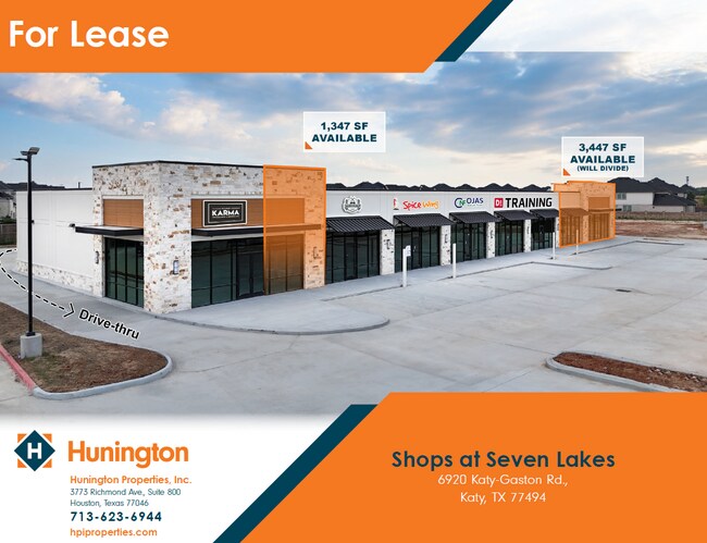
Current Lease Availabilities
Property Detail
Fm 1093
Houston-Pasadena-The Woodlands, TX
0435 WALT-HILL-WALT A, TRACT 1, ACRES 4.243, PARCEL TX-FB-0006, FM 1093
0435-00-002-0001-914
FORT BEND
Taxexempt
Texas
B and X Area of moderate flood hazard, usually the area between the limits of the 100-year and 500-year floods.
4.24 AC
0
Far Katy South
2025
Houston
673112
NEARBY LISTINGS FOR SALE OR LEASE
DEMOGRAPHICS near Fm 1093
1 mile
3 mile
5 mile
2025 Total Population
17,809
107,521
262,925
2030 Population
20,341
121,602
296,607
Pop Growth 2025-2030
+ 14.22%
+ 13.10%
+ 12.81%
Average Age
35
36
36
2025 Total Households
5,651
32,919
81,877
HH Growth 2025-2030
+ 14.69%
+ 13.58%
+ 13.19%
Median Household Inc
$141,666
$143,588
$133,931
Avg Household Size
3.10
3.20
3.20
2025 Avg HH Vehicles
2.00
2.00
2.00
Median Home Value
$451,528
$452,896
$453,362
Median Year Built
2010
2010
2010
Nearby Places
Map Layers
Map Styles
 Street
 Aerial
Layers
 Traffic
 Biking
Places
Listings with unknown addresses are not visible on the map
- Restaurants
- Banks
- Shops
- Fitness
- Groceries
PUBLIC TRANSPORTATION
AIRPORT
William P Hobby
Drive
Walk
Distance
William P Hobby
54 min
37.5 mi
George Bush Intcntl/Houston
Drive
Walk
Distance
George Bush Intcntl/Houston
56 min
46.0 mi
Freight Ports
Port of Houston
Drive
Walk
Distance
Port of Houston
50 min
36.9 mi
Nearby Properties
Address
Land Use
TOTAL SIZE
Lot Size
Zoning
Address
Land Use
TOTAL SIZE
Lot Size
Zoning
786,753 SF
116.13 AC
Address
Land Use
TOTAL SIZE
Lot Size
Zoning
57.20 AC
Address
Land Use
TOTAL SIZE
Lot Size
Zoning
610,000 SF
99.39 AC
Y
Address
Land Use
TOTAL SIZE
Lot Size
Zoning
350,883 SF
29.41 AC
Address
Land Use
TOTAL SIZE
Lot Size
Zoning
481,055 SF
4.56 AC
Address
Land Use
TOTAL SIZE
Lot Size
Zoning
1,022 SF
21.43 AC
RAD
Address
Land Use
TOTAL SIZE
Lot Size
Zoning
13.15 AC
Address
Land Use
TOTAL SIZE
Lot Size
Zoning
15.88 AC
X
Address
Land Use
TOTAL SIZE
Lot Size
Zoning
13.36 AC
QY
Address
Land Use
TOTAL SIZE
Lot Size
Zoning
Address
Land Use
TOTAL SIZE
Lot Size
Zoning
95,597 SF
13.46 AC
Address
Land Use
TOTAL SIZE
Lot Size
Zoning
320,427 SF
15.15 AC
Address
Land Use
TOTAL SIZE
Lot Size
Zoning
240,930 SF
15 AC
Address
Land Use
TOTAL SIZE
Lot Size
Zoning
388,578 SF
16.78 AC
Address
Land Use
TOTAL SIZE
Lot Size
Zoning
105,718 SF
14.52 AC
Address
Land Use
TOTAL SIZE
Lot Size
Zoning
202,589 SF
9.24 AC
J
Address
Land Use
TOTAL SIZE
Lot Size
Zoning
169,191 SF
14.42 AC
Address
Land Use
TOTAL SIZE
Lot Size
Zoning
184,398 SF
28.22 AC
I
Address
Land Use
TOTAL SIZE
Lot Size
Zoning
141,552 SF
38.03 AC
TS
Address
Land Use
TOTAL SIZE
Lot Size
Zoning
390,016 SF
14.44 AC
Address
Land Use
TOTAL SIZE
Lot Size
Zoning
89,262 SF
13.22 AC
Address
Land Use
TOTAL SIZE
Lot Size
Zoning
213,260 SF
9.48 AC
Address
Land Use
TOTAL SIZE
Lot Size
Zoning
Address
Land Use
TOTAL SIZE
Lot Size
Zoning
200,793 SF
6.23 AC
Address
Land Use
TOTAL SIZE
Lot Size
Zoning
92,916 SF
7.96 AC
Address
Land Use
TOTAL SIZE
Lot Size
Zoning
188,625 SF
8.24 AC
Address
Land Use
TOTAL SIZE
Lot Size
Zoning
123,966 SF
13.71 AC
Address
Land Use
TOTAL SIZE
Lot Size
Zoning
123,154 SF
10.83 AC
Address
Land Use
TOTAL SIZE
Lot Size
Zoning
146,600 SF
16.91 AC
SX
Address
Land Use
TOTAL SIZE
Lot Size
Zoning
121,638 SF
12.95 AC
I
The World's #1 Commercial Real Estate Marketplace
Connect with us
© 2026 CoStar Group
The information above has been obtained from sources believed reliable. While we do not doubt its accuracy we have not verified it and make no guarantee, warranty or representation about it. It is your responsibility to independently confirm its accuracy and completeness. Any projections, opinions, assumptions, or estimates used are for example only and do not represent the current or future performance of the property. The value of this transaction to you depends on tax and other factors which should be evaluated by your tax, financial, and legal advisors. You and your advisors should conduct a careful, independent investigation of the property to determine to your satisfaction the suitability of the property for your needs.