Property Record
Fm 1093, Katy, TX 77494


Property Detail
Fm 1093
Houston-Pasadena-The Woodlands, TX
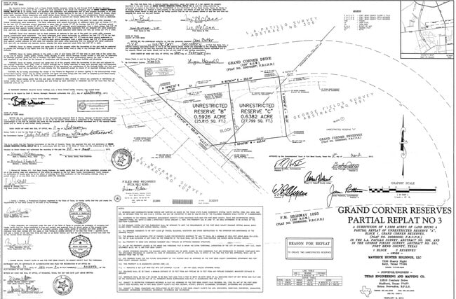
GRAND CORNER RESERVES, BLOCK 1, ACRES 0.6382, PARTIAL REPLAT NO 3, UNRESTRICTED RESERVE C, IN FORT BEND ESD NO 100
3516-00-001-0016-914
FORT BEND
Commercialacreage
Texas
B and X Area of moderate flood hazard, usually the area between the limits of the 100-year and 500-year floods.
0.64 AC
2024
Katy/Grand Parkway West
2025
Houston
673112
NEARBY LISTINGS FOR SALE OR LEASE
DEMOGRAPHICS near Fm 1093
1 mile
3 mile
5 mile
2025 Total Population
16,257
111,547
282,487
2030 Population
18,453
126,488
317,027
Pop Growth 2025-2030
+ 13.51%
+ 13.39%
+ 12.23%
Average Age
36
37
36
2025 Total Households
5,155
35,228
88,668
HH Growth 2025-2030
+ 13.93%
+ 13.81%
+ 12.55%
Median Household Inc
$139,035
$132,437
$123,687
Avg Household Size
3.20
3.20
3.20
2025 Avg HH Vehicles
2.00
2.00
2.00
Median Home Value
$447,016
$445,970
$425,940
Median Year Built
2010
2009
2010
Nearby Places
Map Layers
Map Styles
 Street
 Aerial
Layers
 Traffic
 Biking
Places
Listings with unknown addresses are not visible on the map
- Restaurants
- Banks
- Shops
- Fitness
- Groceries
PUBLIC TRANSPORTATION
AIRPORT
William P Hobby
Drive
Walk
Distance
William P Hobby
53 min
36.8 mi
Freight Ports
Port of Houston
Drive
Walk
Distance
Port of Houston
49 min
36.2 mi
SALE & LEASE HISTORY
LISTING DATE
SALE/LEASE

Jun 04, 2018
For Sale
Apr 10, 2025
For Sale
Nearby Properties
Address
Land Use
TOTAL SIZE
Lot Size
Zoning
Address
Land Use
TOTAL SIZE
Lot Size
Zoning
786,753 SF
116.13 AC
Address
Land Use
TOTAL SIZE
Lot Size
Zoning
57.20 AC
Address
Land Use
TOTAL SIZE
Lot Size
Zoning
523,641 SF
17.31 AC
X
Address
Land Use
TOTAL SIZE
Lot Size
Zoning
900 SF
20.64 AC
MS
Address
Land Use
TOTAL SIZE
Lot Size
Zoning
481,055 SF
4.56 AC
Address
Land Use
TOTAL SIZE
Lot Size
Zoning
22.52 AC
Address
Land Use
TOTAL SIZE
Lot Size
Zoning
15.86 AC
Address
Land Use
TOTAL SIZE
Lot Size
Zoning
13.15 AC
Address
Land Use
TOTAL SIZE
Lot Size
Zoning
15.88 AC
X
Address
Land Use
TOTAL SIZE
Lot Size
Zoning
20.70 AC
Address
Land Use
TOTAL SIZE
Lot Size
Zoning
13.36 AC
QY
Address
Land Use
TOTAL SIZE
Lot Size
Zoning
Address
Land Use
TOTAL SIZE
Lot Size
Zoning
95,597 SF
13.46 AC
Address
Land Use
TOTAL SIZE
Lot Size
Zoning
320,427 SF
15.15 AC
Address
Land Use
TOTAL SIZE
Lot Size
Zoning
240,930 SF
15 AC
Address
Land Use
TOTAL SIZE
Lot Size
Zoning
388,578 SF
16.78 AC
Address
Land Use
TOTAL SIZE
Lot Size
Zoning
105,718 SF
14.52 AC
Address
Land Use
TOTAL SIZE
Lot Size
Zoning
26,631 SF
10.61 AC
Address
Land Use
TOTAL SIZE
Lot Size
Zoning
202,589 SF
9.24 AC
J
Address
Land Use
TOTAL SIZE
Lot Size
Zoning
169,191 SF
14.42 AC
Address
Land Use
TOTAL SIZE
Lot Size
Zoning
101,783 SF
14.43 AC
Address
Land Use
TOTAL SIZE
Lot Size
Zoning
184,398 SF
28.22 AC
I
Address
Land Use
TOTAL SIZE
Lot Size
Zoning
141,552 SF
38.03 AC
TS
Address
Land Use
TOTAL SIZE
Lot Size
Zoning
101,443 SF
11.60 AC
S
Address
Land Use
TOTAL SIZE
Lot Size
Zoning
390,016 SF
14.44 AC
Address
Land Use
TOTAL SIZE
Lot Size
Zoning
285,735 SF
14.63 AC
Address
Land Use
TOTAL SIZE
Lot Size
Zoning
11.30 AC
Address
Land Use
TOTAL SIZE
Lot Size
Zoning
89,262 SF
13.22 AC
Address
Land Use
TOTAL SIZE
Lot Size
Zoning
14.18 AC
Address
Land Use
TOTAL SIZE
Lot Size
Zoning
217,323 SF
29.10 AC
The World's #1 Commercial Real Estate Marketplace
Connect with us
© 2026 CoStar Group
The information above has been obtained from sources believed reliable. While we do not doubt its accuracy we have not verified it and make no guarantee, warranty or representation about it. It is your responsibility to independently confirm its accuracy and completeness. Any projections, opinions, assumptions, or estimates used are for example only and do not represent the current or future performance of the property. The value of this transaction to you depends on tax and other factors which should be evaluated by your tax, financial, and legal advisors. You and your advisors should conduct a careful, independent investigation of the property to determine to your satisfaction the suitability of the property for your needs.