Property Record
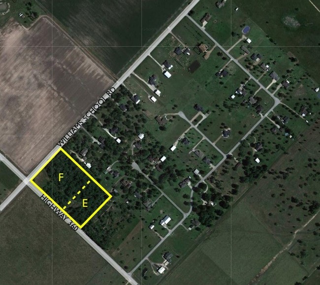
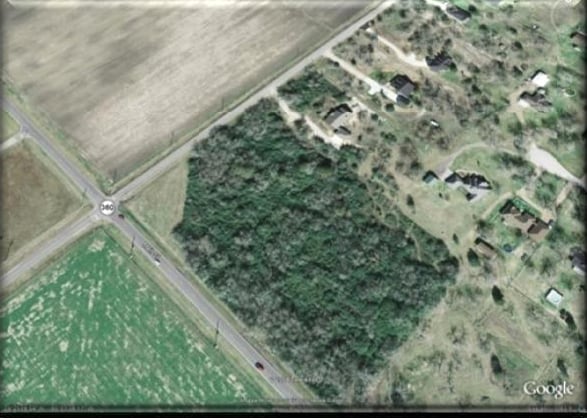
Fm 360, Needville, TX 77461
Property Detail
Fm 360
6440-00-000-1020-906
QUAIL PARK, BLOCK 1, ACRES 2.127, QUAIL PARK REPLAT OF RESERVE E & F, UNRESTRICTED RESERVE E (PART)
Commercialnec
FORT BEND
Y
Texas
B and X Area of moderate flood hazard, usually the area between the limits of the 100-year and 500-year floods.
2.13 AC
2024
Southwest Outlier
2025
Houston
675600
Houston-Pasadena-The Woodlands, TX
NEARBY LISTINGS FOR SALE OR LEASE
-
-
View all Needville listings for sale on LoopNet.com
DEMOGRAPHICS near Fm 360
1 mile
3 mile
5 mile
2024 Total Population
313
6,965
12,651
2029 Population
356
7,926
14,460
Pop Growth 2024-2029
+ 13.74%
+ 13.80%
+ 14.30%
Average Age
40
39
39
2024 Total Households
108
2,426
4,318
HH Growth 2024-2029
+ 14.81%
+ 14.22%
+ 14.68%
Median Household Inc
$59,999
$68,690
$71,765
Avg Household Size
2.90
2.80
2.90
2024 Avg HH Vehicles
2.00
2.00
2.00
Median Home Value
$272,222
$296,133
$338,102
Median Year Built
1989
1993
1995
Nearby Places
Map Layers
Map Styles
 Street
 Aerial
Transit
 Traffic
 Biking
Places
Listings with unknown addresses are not visible on the map
- Restaurants
- Banks
- Shops
- Fitness
- Groceries
Nearby Properties
Address
Land Use
TOTAL SIZE
Lot Size
Zoning
Address
Land Use
TOTAL SIZE
Lot Size
Zoning
113,567 SF
18 AC
Address
Land Use
TOTAL SIZE
Lot Size
Zoning
3.74 AC
SY
Address
Land Use
TOTAL SIZE
Lot Size
Zoning
22,980 SF
7.65 AC
Address
Land Use
TOTAL SIZE
Lot Size
Zoning
18,870 SF
3 AC
O
Address
Land Use
TOTAL SIZE
Lot Size
Zoning
155.81 AC
Address
Land Use
TOTAL SIZE
Lot Size
Zoning
14,234 SF
10.18 AC
Y
Address
Land Use
TOTAL SIZE
Lot Size
Zoning
3,248 SF
89.86 AC
QOY
Address
Land Use
TOTAL SIZE
Lot Size
Zoning
20,053 SF
3.16 AC
Address
Land Use
TOTAL SIZE
Lot Size
Zoning
15,000 SF
1.38 AC
SHMY
Address
Land Use
TOTAL SIZE
Lot Size
Zoning
9,478 SF
3.83 AC
NS
Address
Land Use
TOTAL SIZE
Lot Size
Zoning
20,303 SF
4.72 AC
SY
Address
Land Use
TOTAL SIZE
Lot Size
Zoning
800 SF
100.51 AC
OY
Address
Land Use
TOTAL SIZE
Lot Size
Zoning
98 AC
OS
Address
Land Use
TOTAL SIZE
Lot Size
Zoning
5,862 SF
26.57 AC
Address
Land Use
TOTAL SIZE
Lot Size
Zoning
10,975 SF
1.16 AC
SHMY
Address
Land Use
TOTAL SIZE
Lot Size
Zoning
800 SF
6.77 AC
Address
Land Use
TOTAL SIZE
Lot Size
Zoning
1.91 AC
Address
Land Use
TOTAL SIZE
Lot Size
Zoning
9.17 AC
Address
Land Use
TOTAL SIZE
Lot Size
Zoning
6,848 SF
0.68 AC
Address
Land Use
TOTAL SIZE
Lot Size
Zoning
5,040 SF
1.96 AC
XY
Address
Land Use
TOTAL SIZE
Lot Size
Zoning
6,945 SF
18.39 AC
QS
Address
Land Use
TOTAL SIZE
Lot Size
Zoning
4,000 SF
10.74 AC
Address
Land Use
TOTAL SIZE
Lot Size
Zoning
6,212 SF
1.17 AC
X
Address
Land Use
TOTAL SIZE
Lot Size
Zoning
140 AC
TY
Address
Land Use
TOTAL SIZE
Lot Size
Zoning
77.07 AC
OTS
Address
Land Use
TOTAL SIZE
Lot Size
Zoning
11,258 SF
1.52 AC
Address
Land Use
TOTAL SIZE
Lot Size
Zoning
18.27 AC
Address
Land Use
TOTAL SIZE
Lot Size
Zoning
16,018 SF
3.76 AC
Q
Address
Land Use
TOTAL SIZE
Lot Size
Zoning
2,170 SF
1.47 AC
Address
Land Use
TOTAL SIZE
Lot Size
Zoning
30.83 AC
The World's #1 Commercial Real Estate Marketplace
Connect with us
© 2026 CoStar Group
The information above has been obtained from sources believed reliable. While we do not doubt its accuracy we have not verified it and make no guarantee, warranty or representation about it. It is your responsibility to independently confirm its accuracy and completeness. Any projections, opinions, assumptions, or estimates used are for example only and do not represent the current or future performance of the property. The value of this transaction to you depends on tax and other factors which should be evaluated by your tax, financial, and legal advisors. You and your advisors should conduct a careful, independent investigation of the property to determine to your satisfaction the suitability of the property for your needs.