Property Record
Krupla Rd, Harlingen, TX 78550
This Property Is For Sale
NEARBY LISTINGS FOR SALE OR LEASE
-
-
View all Harlingen listings for sale on LoopNet.com
Property Detail
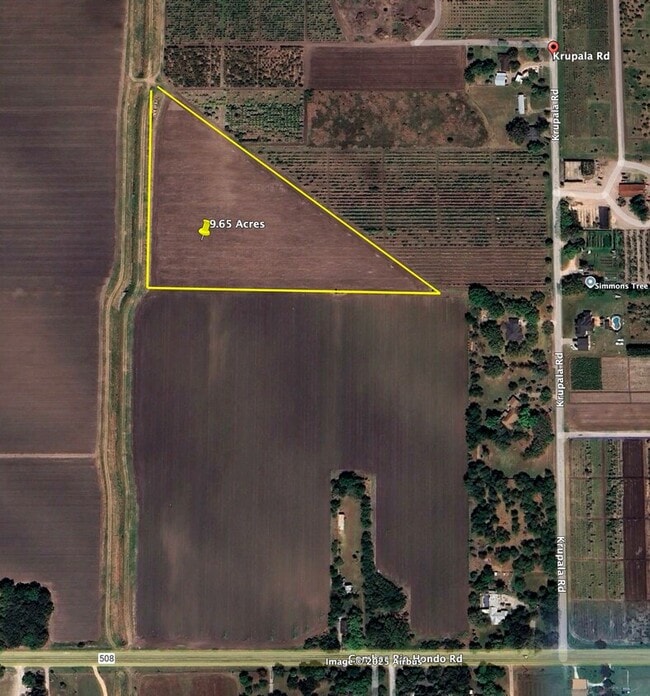
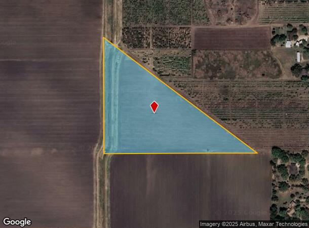
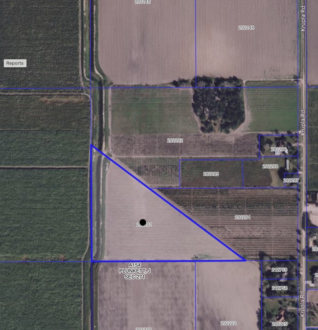
Krupla Rd
Brownsville-Harlingen, TX
Briggs-Coleman Survey 28/271/272
972170-0490-010000
BLK 49 BRIGGS-COLEMAN SURVEY 28/271/272 SW 9.650 ACRES
Agriculturalland
Cameron
X
Texas
48061C0125F
9.65 AC
2024
Outlying Cameron County
2025
Brownsville/Harlingen
010700
DEMOGRAPHICS near Krupla Rd
1 Mile
3 Mile
5 Mile
2024 Total Population
553
2,625
32,730
2029 Population
577
2,704
33,457
Pop Growth 2024-2029
+ 4.34%
+ 3.01%
+ 2.22%
Average Age
38
37
36
2024 Total Households
163
794
11,346
HH Growth 2024-2029
+ 4.29%
+ 3.02%
+ 2.16%
Median Household Inc
$53,030
$55,142
$49,851
Avg Household Size
3.30
3.20
2.80
2024 Avg HH Vehicles
2.00
2.00
2.00
Median Home Value
$117,708
$128,643
$118,909
Median Year Built
1991
1993
1987
Nearby Places
- Restaurants
- Banks
- Shops
- Fitness
- Groceries
PUBLIC TRANSPORTATION
AIRPORT
Valley International
DRIVE
WALK
Distance
Valley International
11 min
3.7 mi
Brownsville/South Padre Island International
DRIVE
WALK
Distance
Brownsville/South Padre Island International
48 min
34.2 mi
Freight Ports
Port of Brownsville
DRIVE
WALK
Distance
Port of Brownsville
41 min
31.8 mi
Nearby Properties
Address
Land Use
TOTAL SIZE
Lot Size
Zoning
Address
Land Use
TOTAL SIZE
Lot Size
Zoning
16,508 SF
347.82 AC
Address
Land Use
TOTAL SIZE
Lot Size
Zoning
68,425 SF
4.40 AC
C
Address
Land Use
TOTAL SIZE
Lot Size
Zoning
63,000 SF
5 AC
I
Address
Land Use
TOTAL SIZE
Lot Size
Zoning
38,340 SF
4.50 AC
Address
Land Use
TOTAL SIZE
Lot Size
Zoning
10,360 SF
2,261.50 AC
Address
Land Use
TOTAL SIZE
Lot Size
Zoning
1,656 SF
6.21 AC
Address
Land Use
TOTAL SIZE
Lot Size
Zoning
3,603 SF
0.98 AC
C
Address
Land Use
TOTAL SIZE
Lot Size
Zoning
13,160 SF
5.78 AC
C
Address
Land Use
TOTAL SIZE
Lot Size
Zoning
3,840 SF
1.73 AC
A-R
Address
Land Use
TOTAL SIZE
Lot Size
Zoning
17,933 SF
3.61 AC
Address
Land Use
TOTAL SIZE
Lot Size
Zoning
12,400 SF
2.50 AC
Address
Land Use
TOTAL SIZE
Lot Size
Zoning
8,029 SF
3.75 AC
A-R
Address
Land Use
TOTAL SIZE
Lot Size
Zoning
300,896 SF
18.36 AC
Address
Land Use
TOTAL SIZE
Lot Size
Zoning
16,508 SF
0.88 AC
Address
Land Use
TOTAL SIZE
Lot Size
Zoning
40.25 AC
Address
Land Use
TOTAL SIZE
Lot Size
Zoning
1,600 SF
0.86 AC
A-R
Address
Land Use
TOTAL SIZE
Lot Size
Zoning
Address
Land Use
TOTAL SIZE
Lot Size
Zoning
2,000 SF
0.99 AC
C
Address
Land Use
TOTAL SIZE
Lot Size
Zoning
19.10 AC
Address
Land Use
TOTAL SIZE
Lot Size
Zoning
3,111 SF
8.56 AC
C
Address
Land Use
TOTAL SIZE
Lot Size
Zoning
439.51 AC
Address
Land Use
TOTAL SIZE
Lot Size
Zoning
561.99 AC
Address
Land Use
TOTAL SIZE
Lot Size
Zoning
3.50 AC
Address
Land Use
TOTAL SIZE
Lot Size
Zoning
1,480 SF
3 AC
Address
Land Use
TOTAL SIZE
Lot Size
Zoning
418.37 AC
Address
Land Use
TOTAL SIZE
Lot Size
Zoning
16.10 AC
Address
Land Use
TOTAL SIZE
Lot Size
Zoning
3,854 SF
1.95 AC
Address
Land Use
TOTAL SIZE
Lot Size
Zoning
6.57 AC
Address
Land Use
TOTAL SIZE
Lot Size
Zoning
2,100 SF
13.73 AC
Address
Land Use
TOTAL SIZE
Lot Size
Zoning
2,560 SF
3.79 AC
The World's #1 Commercial Real Estate Marketplace
Connect with us
© 2025 CoStar Group
The information above has been obtained from sources believed reliable. While we do not doubt its accuracy we have not verified it and make no guarantee, warranty or representation about it. It is your responsibility to independently confirm its accuracy and completeness. Any projections, opinions, assumptions, or estimates used are for example only and do not represent the current or future performance of the property. The value of this transaction to you depends on tax and other factors which should be evaluated by your tax, financial, and legal advisors. You and your advisors should conduct a careful, independent investigation of the property to determine to your satisfaction the suitability of the property for your needs.