Property Record
Fm-471 S Fm-471 S, Hondo, TX 78861
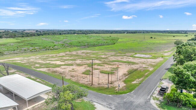


Property Detail
Fm-471 S Fm-471 S
San Antonio-New Braunfels, TX
A0182 J. CONTIS SURVEY 26; ACRES 33.229
2922
MEDINA
Farms
Texas
AE The base floodplain where base flood elevations are provided. AE Zones are now used on new format FIRMs instead of A1-A30 Zones.
33.23 AC
2024
Medina County
2025
San Antonio
000101
NEARBY LISTINGS FOR SALE OR LEASE
-
-
View all Hondo listings for sale on LoopNet.com
DEMOGRAPHICS near Fm-471 S Fm-471 S
1 mile
3 mile
5 mile
2025 Total Population
614
2,372
13,987
2030 Population
591
2,397
15,344
Pop Growth 2025-2030
(3.75%)
+ 1.05%
+ 9.70%
Average Age
43
40
38
2025 Total Households
228
787
4,454
HH Growth 2025-2030
(3.51%)
+ 1.02%
+ 9.56%
Median Household Inc
$68,749
$66,980
$68,717
Avg Household Size
2.70
2.90
3.00
2025 Avg HH Vehicles
3.00
3.00
2.00
Median Home Value
$95,917
$163,664
$268,579
Median Year Built
1991
1992
1999
Nearby Places
Map Layers
Map Styles
 Street
 Aerial
Transit
 Traffic
 Biking
Places
Listings with unknown addresses are not visible on the map
- Restaurants
- Banks
- Shops
- Fitness
- Groceries
PUBLIC TRANSPORTATION
AIRPORT
San Antonio International
Drive
Walk
Distance
San Antonio International
38 min
29.6 mi
Freight Ports
Port of Corpus Christi
Drive
Walk
Distance
Port of Corpus Christi
173 min
165.2 mi
SALE & LEASE HISTORY
LISTING DATE
SALE/LEASE

Feb 26, 2025
For Sale
Nearby Properties
Address
Land Use
TOTAL SIZE
Lot Size
Zoning
Address
Land Use
TOTAL SIZE
Lot Size
Zoning
655.86 AC
Address
Land Use
TOTAL SIZE
Lot Size
Zoning
341,380 SF
15.40 AC
Address
Land Use
TOTAL SIZE
Lot Size
Zoning
309.89 AC
Address
Land Use
TOTAL SIZE
Lot Size
Zoning
139.01 AC
Address
Land Use
TOTAL SIZE
Lot Size
Zoning
113.30 AC
Address
Land Use
TOTAL SIZE
Lot Size
Zoning
90.62 AC
Address
Land Use
TOTAL SIZE
Lot Size
Zoning
117.86 AC
Address
Land Use
TOTAL SIZE
Lot Size
Zoning
520 SF
87.80 AC
Address
Land Use
TOTAL SIZE
Lot Size
Zoning
75.08 AC
Address
Land Use
TOTAL SIZE
Lot Size
Zoning
680 SF
191.32 AC
Address
Land Use
TOTAL SIZE
Lot Size
Zoning
43,688 SF
11.72 AC
Address
Land Use
TOTAL SIZE
Lot Size
Zoning
64.67 AC
Address
Land Use
TOTAL SIZE
Lot Size
Zoning
Address
Land Use
TOTAL SIZE
Lot Size
Zoning
14,400 SF
2.86 AC
Address
Land Use
TOTAL SIZE
Lot Size
Zoning
179.15 AC
Address
Land Use
TOTAL SIZE
Lot Size
Zoning
82.43 AC
Address
Land Use
TOTAL SIZE
Lot Size
Zoning
11,306 SF
43.03 AC
Address
Land Use
TOTAL SIZE
Lot Size
Zoning
120.63 AC
Address
Land Use
TOTAL SIZE
Lot Size
Zoning
64.38 AC
Address
Land Use
TOTAL SIZE
Lot Size
Zoning
49.45 AC
Address
Land Use
TOTAL SIZE
Lot Size
Zoning
3,972 SF
5.35 AC
Address
Land Use
TOTAL SIZE
Lot Size
Zoning
56.91 AC
Address
Land Use
TOTAL SIZE
Lot Size
Zoning
Address
Land Use
TOTAL SIZE
Lot Size
Zoning
1.33 AC
Address
Land Use
TOTAL SIZE
Lot Size
Zoning
Address
Land Use
TOTAL SIZE
Lot Size
Zoning
46.36 AC
Address
Land Use
TOTAL SIZE
Lot Size
Zoning
71.13 AC
Address
Land Use
TOTAL SIZE
Lot Size
Zoning
Address
Land Use
TOTAL SIZE
Lot Size
Zoning
1,406 SF
59.54 AC
Address
Land Use
TOTAL SIZE
Lot Size
Zoning
43.87 AC
The World's #1 Commercial Real Estate Marketplace
Connect with us
© 2026 CoStar Group
The information above has been obtained from sources believed reliable. While we do not doubt its accuracy we have not verified it and make no guarantee, warranty or representation about it. It is your responsibility to independently confirm its accuracy and completeness. Any projections, opinions, assumptions, or estimates used are for example only and do not represent the current or future performance of the property. The value of this transaction to you depends on tax and other factors which should be evaluated by your tax, financial, and legal advisors. You and your advisors should conduct a careful, independent investigation of the property to determine to your satisfaction the suitability of the property for your needs.