Property Record
Fm 849, Lindale, TX 75771

This Property Is For Sale
Property Detail
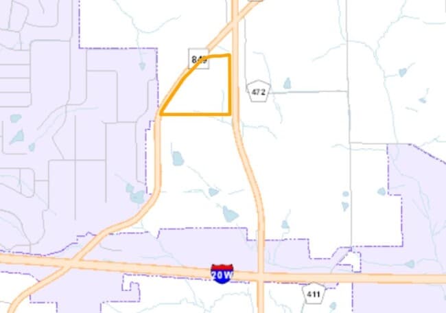
Fm 849
Tyler, TX
ABST A0217 S COLEMAN ABST A0217 S COLEMAN ABST A0217 S COLEMAN TRACT 4 TRACT 4B TRACT 4A WAS 57.782AC/ 2018 SPLIT SEE NOTES
1-00000-0217-00-004000
SMITH
Agriculturalland
Texas
B and X Area of moderate flood hazard, usually the area between the limits of the 100-year and 500-year floods.
44.32 AC
2025
Tyler
2025
Other Market Areas
001404
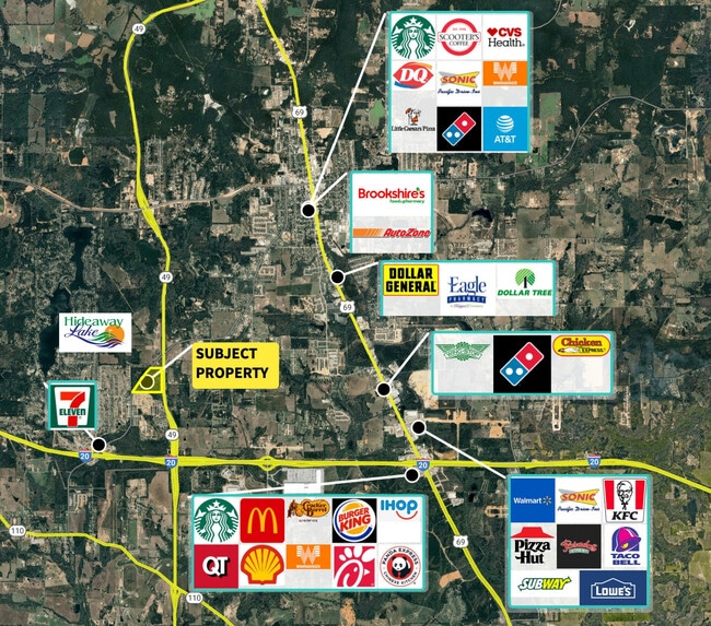
NEARBY LISTINGS FOR SALE OR LEASE
DEMOGRAPHICS near Fm 849
1 mile
3 mile
5 mile
2025 Total Population
1,443
11,880
21,363
2030 Population
1,532
12,670
22,790
Pop Growth 2025-2030
+ 6.17%
+ 6.65%
+ 6.68%
Average Age
51
43
41
2025 Total Households
631
4,554
7,948
HH Growth 2025-2030
+ 5.55%
+ 6.19%
+ 6.19%
Median Household Inc
$94,306
$90,437
$92,661
Avg Household Size
2.30
2.50
2.60
2025 Avg HH Vehicles
2.00
2.00
2.00
Median Home Value
$379,860
$298,090
$300,871
Median Year Built
1988
1991
1992
Nearby Places
Map Layers
Map Styles
 Street
 Aerial
Transit
 Traffic
 Biking
Places
Listings with unknown addresses are not visible on the map
- Restaurants
- Banks
- Shops
- Fitness
- Groceries
PUBLIC TRANSPORTATION
AIRPORT
Tyler Pounds Regional
Drive
Walk
Distance
Tyler Pounds Regional
19 min
11.9 mi
Freight Ports
Port of Shreveport
Drive
Walk
Distance
Port of Shreveport
126 min
113.9 mi
Nearby Properties
Address
Land Use
TOTAL SIZE
Lot Size
Zoning
Address
Land Use
TOTAL SIZE
Lot Size
Zoning
1,680,000 SF
145.53 AC
Address
Land Use
TOTAL SIZE
Lot Size
Zoning
87,195 SF
5.44 AC
Address
Land Use
TOTAL SIZE
Lot Size
Zoning
72,185 SF
17.53 AC
Address
Land Use
TOTAL SIZE
Lot Size
Zoning
2,094 SF
6.94 AC
Address
Land Use
TOTAL SIZE
Lot Size
Zoning
163,900 SF
27.35 AC
Address
Land Use
TOTAL SIZE
Lot Size
Zoning
32,238 SF
10.61 AC
Address
Land Use
TOTAL SIZE
Lot Size
Zoning
104,953 SF
6.37 AC
Address
Land Use
TOTAL SIZE
Lot Size
Zoning
16,625 SF
5.82 AC
Address
Land Use
TOTAL SIZE
Lot Size
Zoning
1,036 SF
5.53 AC
Address
Land Use
TOTAL SIZE
Lot Size
Zoning
15,292 SF
2 AC
Address
Land Use
TOTAL SIZE
Lot Size
Zoning
3.18 AC
Address
Land Use
TOTAL SIZE
Lot Size
Zoning
41,612 SF
1.50 AC
Address
Land Use
TOTAL SIZE
Lot Size
Zoning
10,164 SF
0.91 AC
Address
Land Use
TOTAL SIZE
Lot Size
Zoning
15,232 SF
4.37 AC
Address
Land Use
TOTAL SIZE
Lot Size
Zoning
44,147 SF
Address
Land Use
TOTAL SIZE
Lot Size
Zoning
4,200 SF
3.10 AC
Address
Land Use
TOTAL SIZE
Lot Size
Zoning
3.10 AC
Address
Land Use
TOTAL SIZE
Lot Size
Zoning
14,260 SF
5.39 AC
Address
Land Use
TOTAL SIZE
Lot Size
Zoning
1.31 AC
Address
Land Use
TOTAL SIZE
Lot Size
Zoning
6,689 SF
4.90 AC
Address
Land Use
TOTAL SIZE
Lot Size
Zoning
9,300 SF
1.29 AC
Address
Land Use
TOTAL SIZE
Lot Size
Zoning
Address
Land Use
TOTAL SIZE
Lot Size
Zoning
40.32 AC
Address
Land Use
TOTAL SIZE
Lot Size
Zoning
5,000 SF
1.18 AC
Address
Land Use
TOTAL SIZE
Lot Size
Zoning
Address
Land Use
TOTAL SIZE
Lot Size
Zoning
13,435 SF
2.12 AC
Address
Land Use
TOTAL SIZE
Lot Size
Zoning
13.30 AC
Address
Land Use
TOTAL SIZE
Lot Size
Zoning
6,800 SF
5.36 AC
Address
Land Use
TOTAL SIZE
Lot Size
Zoning
45.76 AC
Address
Land Use
TOTAL SIZE
Lot Size
Zoning
4,635 SF
1.10 AC
The World's #1 Commercial Real Estate Marketplace
Connect with us
© 2026 CoStar Group
The information above has been obtained from sources believed reliable. While we do not doubt its accuracy we have not verified it and make no guarantee, warranty or representation about it. It is your responsibility to independently confirm its accuracy and completeness. Any projections, opinions, assumptions, or estimates used are for example only and do not represent the current or future performance of the property. The value of this transaction to you depends on tax and other factors which should be evaluated by your tax, financial, and legal advisors. You and your advisors should conduct a careful, independent investigation of the property to determine to your satisfaction the suitability of the property for your needs.