Property Record
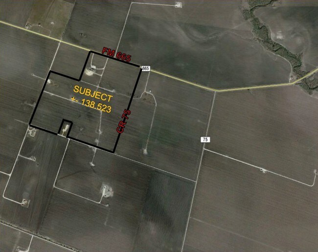
Fm Rr 665, Robstown, TX 78380


Property Detail
Fm Rr 665
283664
PAUL G H 138.523 ACS OUT NW/4 SEC 126
Farms
NUECES
OCL
Texas
A Areas with a 1% annual chance of flooding and a 26% chance of flooding over the life of a 30-year mortgage.
138.52 AC
2024
Southwest
2025
Corpus Christi
005804
Corpus Christi, TX
NEARBY LISTINGS FOR SALE OR LEASE
DEMOGRAPHICS near Fm Rr 665
1 mile
3 mile
5 mile
2025 Total Population
209
634
1,659
2030 Population
198
607
1,617
Pop Growth 2025-2030
(5.26%)
(4.26%)
(2.53%)
Average Age
37
37
38
2025 Total Households
64
195
399
HH Growth 2025-2030
(4.69%)
(4.62%)
(3.76%)
Median Household Inc
$38,815
$39,134
$39,930
Avg Household Size
3.20
3.20
3.10
2025 Avg HH Vehicles
2.00
2.00
2.00
Median Home Value
$86,538
$91,891
$139,705
Median Year Built
1972
1980
1986
Nearby Places
Map Layers
Map Styles
 Street
 Aerial
Layers
 Traffic
 Biking
Places
Listings with unknown addresses are not visible on the map
- Restaurants
- Banks
- Shops
- Fitness
- Groceries
PUBLIC TRANSPORTATION
AIRPORT
Corpus Christi International
Drive
Walk
Distance
Corpus Christi International
33 min
21.9 mi
Freight Ports
Port of Corpus Christi
Drive
Walk
Distance
Port of Corpus Christi
41 min
29.6 mi
SALE & LEASE HISTORY
LISTING DATE
SALE/LEASE

Sep 24, 2016
For Sale
Nearby Properties
Address
Land Use
TOTAL SIZE
Lot Size
Zoning
Address
Land Use
TOTAL SIZE
Lot Size
Zoning
6.36 AC
Address
Land Use
TOTAL SIZE
Lot Size
Zoning
64,123 SF
90 AC
OCL
Address
Land Use
TOTAL SIZE
Lot Size
Zoning
Address
Land Use
TOTAL SIZE
Lot Size
Zoning
9,000 SF
2.31 AC
Address
Land Use
TOTAL SIZE
Lot Size
Zoning
0.96 AC
Address
Land Use
TOTAL SIZE
Lot Size
Zoning
12,104 SF
2.76 AC
Address
Land Use
TOTAL SIZE
Lot Size
Zoning
2,870 SF
0.60 AC
Address
Land Use
TOTAL SIZE
Lot Size
Zoning
5.88 AC
Address
Land Use
TOTAL SIZE
Lot Size
Zoning
3,788 SF
3 AC
Address
Land Use
TOTAL SIZE
Lot Size
Zoning
2,867 SF
3.75 AC
Address
Land Use
TOTAL SIZE
Lot Size
Zoning
Address
Land Use
TOTAL SIZE
Lot Size
Zoning
699.62 AC
OCL
Address
Land Use
TOTAL SIZE
Lot Size
Zoning
154.78 AC
OCL
Address
Land Use
TOTAL SIZE
Lot Size
Zoning
2,721 SF
0.69 AC
Address
Land Use
TOTAL SIZE
Lot Size
Zoning
2,928 SF
0.99 AC
Address
Land Use
TOTAL SIZE
Lot Size
Zoning
2,910 SF
1.50 AC
Address
Land Use
TOTAL SIZE
Lot Size
Zoning
1,544 SF
0.71 AC
Address
Land Use
TOTAL SIZE
Lot Size
Zoning
2,368 SF
7 AC
Address
Land Use
TOTAL SIZE
Lot Size
Zoning
3,780 SF
1.04 AC
Address
Land Use
TOTAL SIZE
Lot Size
Zoning
55.43 AC
OCL
Address
Land Use
TOTAL SIZE
Lot Size
Zoning
3,300 SF
0.48 AC
Address
Land Use
TOTAL SIZE
Lot Size
Zoning
3,600 SF
4.01 AC
Address
Land Use
TOTAL SIZE
Lot Size
Zoning
6,800 SF
2.50 AC
Address
Land Use
TOTAL SIZE
Lot Size
Zoning
2,488 SF
0.67 AC
OCL
Address
Land Use
TOTAL SIZE
Lot Size
Zoning
1,760 SF
0.57 AC
Address
Land Use
TOTAL SIZE
Lot Size
Zoning
383.35 AC
OCL
Address
Land Use
TOTAL SIZE
Lot Size
Zoning
1,517 SF
1.31 AC
Address
Land Use
TOTAL SIZE
Lot Size
Zoning
4,000 SF
0.48 AC
Address
Land Use
TOTAL SIZE
Lot Size
Zoning
1,872 SF
0.89 AC
Address
Land Use
TOTAL SIZE
Lot Size
Zoning
1,701 SF
1 AC
The World's #1 Commercial Real Estate Marketplace
Connect with us
© 2026 CoStar Group
The information above has been obtained from sources believed reliable. While we do not doubt its accuracy we have not verified it and make no guarantee, warranty or representation about it. It is your responsibility to independently confirm its accuracy and completeness. Any projections, opinions, assumptions, or estimates used are for example only and do not represent the current or future performance of the property. The value of this transaction to you depends on tax and other factors which should be evaluated by your tax, financial, and legal advisors. You and your advisors should conduct a careful, independent investigation of the property to determine to your satisfaction the suitability of the property for your needs.