Property Record
Folsom Blvd, Sacramento, CA 95827
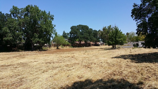

Property Detail
Folsom Blvd
Sacramento-Roseville-Folsom, CA
PARCEL MAP, LOT 4
075-0040-040
SACRAMENTO
Residentialacreage
California
SPA
4
C and X Area of minimal flood hazard, usually depicted on FIRMs as above the 500-year flood level.
0.93 AC
2024
Highway 50 Corridor
2025
Sacramento
009004
NEARBY LISTINGS FOR SALE OR LEASE
DEMOGRAPHICS near Folsom Blvd
1 mile
3 mile
5 mile
2025 Total Population
11,787
111,811
265,807
2030 Population
11,867
113,006
268,669
Pop Growth 2025-2030
+ 0.68%
+ 1.07%
+ 1.08%
Average Age
40
40
40
2025 Total Households
4,390
42,562
104,231
HH Growth 2025-2030
+ 0.71%
+ 1.12%
+ 1.12%
Median Household Inc
$99,372
$91,823
$83,072
Avg Household Size
2.60
2.60
2.40
2025 Avg HH Vehicles
2.00
2.00
2.00
Median Home Value
$488,207
$496,596
$499,999
Median Year Built
1974
1972
1972
Nearby Places
Map Layers
Map Styles
 Street
 Aerial
Layers
 Traffic
 Biking
Places
Listings with unknown addresses are not visible on the map
- Restaurants
- Banks
- Shops
- Fitness
- Groceries
PUBLIC TRANSPORTATION
TRANSIT/SUBWAY
Butterfield (Gold Line - Sacramento Regional Transit District Light Rail (The RT))
Drive
Walk
Distance
Butterfield (Gold Line - Sacramento Regional Transit District Light Rail (The RT))
1 min
8 min
0.5 mi
Tiber (Gold Line - Sacramento Regional Transit District Light Rail (The RT))
Drive
Walk
Distance
Tiber (Gold Line - Sacramento Regional Transit District Light Rail (The RT))
1 min
16 min
0.9 mi
AIRPORT
Sacramento International
Drive
Walk
Distance
Sacramento International
30 min
22.2 mi
Freight Ports
Port of Stockton
Drive
Walk
Distance
Port of Stockton
66 min
55.8 mi
SALE & LEASE HISTORY
LISTING DATE
SALE/LEASE

Sep 24, 2016
For Sale
Oct 25, 2017
For Sale
May 02, 2017
For Sale
Mar 19, 2021
For Sale
Jan 28, 2022
For Sale
Apr 06, 2023
For Sale
Nearby Properties
Address
Land Use
TOTAL SIZE
Lot Size
Zoning
Address
Land Use
TOTAL SIZE
Lot Size
Zoning
266,841 SF
47.29 AC
RD-5
Address
Land Use
TOTAL SIZE
Lot Size
Zoning
223,046 SF
10.99 AC
RD 20
Address
Land Use
TOTAL SIZE
Lot Size
Zoning
109,805 SF
20.04 AC
OPMU
Address
Land Use
TOTAL SIZE
Lot Size
Zoning
181,573 SF
12.10 AC
SPA (MFSPA
Address
Land Use
TOTAL SIZE
Lot Size
Zoning
137,520 SF
10.37 AC
BP (PC)(PD
Address
Land Use
TOTAL SIZE
Lot Size
Zoning
387,136 SF
8.85 AC
RD-30
Address
Land Use
TOTAL SIZE
Lot Size
Zoning
168,846 SF
7.58 AC
RD-30 (PC)
Address
Land Use
TOTAL SIZE
Lot Size
Zoning
139,500 SF
5.21 AC
MP
Address
Land Use
TOTAL SIZE
Lot Size
Zoning
162,023 SF
8.96 AC
OIMU
Address
Land Use
TOTAL SIZE
Lot Size
Zoning
119,824 SF
7.64 AC
RD-30 (PC)
Address
Land Use
TOTAL SIZE
Lot Size
Zoning
0.21 AC
RD-5
Address
Land Use
TOTAL SIZE
Lot Size
Zoning
135,375 SF
7.40 AC
RD-30
Address
Land Use
TOTAL SIZE
Lot Size
Zoning
221,337 SF
12.19 AC
RD 25
Address
Land Use
TOTAL SIZE
Lot Size
Zoning
95,174 SF
5.29 AC
SPA (MFSPA
Address
Land Use
TOTAL SIZE
Lot Size
Zoning
198,131 SF
13.36 AC
BP
Address
Land Use
TOTAL SIZE
Lot Size
Zoning
156,032 SF
9.31 AC
OPMU
Address
Land Use
TOTAL SIZE
Lot Size
Zoning
169,618 SF
10.44 AC
RD-4
Address
Land Use
TOTAL SIZE
Lot Size
Zoning
198,413 SF
9.24 AC
RD 30
Address
Land Use
TOTAL SIZE
Lot Size
Zoning
12.47 AC
RD 30
Address
Land Use
TOTAL SIZE
Lot Size
Zoning
457,088 SF
12.50 AC
RD 30
Address
Land Use
TOTAL SIZE
Lot Size
Zoning
89,098 SF
4.93 AC
RD-40
Address
Land Use
TOTAL SIZE
Lot Size
Zoning
302,966 SF
15.94 AC
RD 30
Address
Land Use
TOTAL SIZE
Lot Size
Zoning
258,819 SF
13.47 AC
RD 30
Address
Land Use
TOTAL SIZE
Lot Size
Zoning
8,724 SF
101.84 AC
M-2 (SM)
Address
Land Use
TOTAL SIZE
Lot Size
Zoning
101,301 SF
9.35 AC
SC
Address
Land Use
TOTAL SIZE
Lot Size
Zoning
387,136 SF
10.21 AC
RD-30
Address
Land Use
TOTAL SIZE
Lot Size
Zoning
110,960 SF
6.62 AC
SPA (MFSPA
Address
Land Use
TOTAL SIZE
Lot Size
Zoning
90,972 SF
2.36 AC
RD-40
Address
Land Use
TOTAL SIZE
Lot Size
Zoning
184,249 SF
10.72 AC
OIMU (FBSP
Address
Land Use
TOTAL SIZE
Lot Size
Zoning
100,000 SF
7.03 AC
SPA (MFSPA
The World's #1 Commercial Real Estate Marketplace
Connect with us
© 2026 CoStar Group
The information above has been obtained from sources believed reliable. While we do not doubt its accuracy we have not verified it and make no guarantee, warranty or representation about it. It is your responsibility to independently confirm its accuracy and completeness. Any projections, opinions, assumptions, or estimates used are for example only and do not represent the current or future performance of the property. The value of this transaction to you depends on tax and other factors which should be evaluated by your tax, financial, and legal advisors. You and your advisors should conduct a careful, independent investigation of the property to determine to your satisfaction the suitability of the property for your needs.