Property Record
Boston Rd, Strongsville, OH 44149
This Property Is For Sale
NEARBY LISTINGS FOR SALE OR LEASE
Property Detail
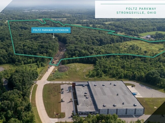
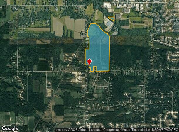
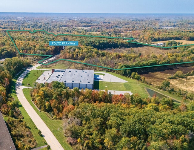
Boston Rd
394-08-005
RESIDUAL AFN- 201910170346
Officebuilding
Cuyahoga
X
Ohio
39035C0286E
139.93 AC
0
Southwest
2024
Cleveland
186206
Cleveland-Elyria, OH
DEMOGRAPHICS near Boston Rd
1 Mile
3 Mile
5 Mile
2024 Total Population
829
37,475
95,407
2029 Population
819
37,369
95,518
Pop Growth 2024-2029
(1.21%)
(0.28%)
+ 0.12%
Average Age
44
43
43
2024 Total Households
307
14,251
37,810
HH Growth 2024-2029
(0.98%)
(0.34%)
(0.06%)
Median Household Inc
$107,258
$99,959
$93,840
Avg Household Size
2.60
2.60
2.50
2024 Avg HH Vehicles
2.00
2.00
2.00
Median Home Value
$393,076
$293,401
$280,392
Median Year Built
1992
1985
1980
Nearby Places
- Restaurants
- Banks
- Shops
- Fitness
- Groceries
PUBLIC TRANSPORTATION
AIRPORT
Cleveland-Hopkins International
DRIVE
WALK
Distance
Cleveland-Hopkins International
29 min
13.3 mi
Freight Ports
Port of Toledo
DRIVE
WALK
Distance
Port of Toledo
133 min
107.2 mi
Nearby Properties
Address
Land Use
TOTAL SIZE
Lot Size
Zoning
Address
Land Use
TOTAL SIZE
Lot Size
Zoning
345,524 SF
107.02 AC
PF
Address
Land Use
TOTAL SIZE
Lot Size
Zoning
53,653 SF
30.83 AC
Address
Land Use
TOTAL SIZE
Lot Size
Zoning
230,291 SF
17.35 AC
Address
Land Use
TOTAL SIZE
Lot Size
Zoning
437,700 SF
36.09 AC
GI
Address
Land Use
TOTAL SIZE
Lot Size
Zoning
310,080 SF
28.30 AC
GI
Address
Land Use
TOTAL SIZE
Lot Size
Zoning
381,528 SF
42.50 AC
GI
Address
Land Use
TOTAL SIZE
Lot Size
Zoning
120,478 SF
17.45 AC
Address
Land Use
TOTAL SIZE
Lot Size
Zoning
167,946 SF
33.22 AC
Address
Land Use
TOTAL SIZE
Lot Size
Zoning
180,606 SF
10.99 AC
Address
Land Use
TOTAL SIZE
Lot Size
Zoning
149,184 SF
14.09 AC
PDA-2
Address
Land Use
TOTAL SIZE
Lot Size
Zoning
185,284 SF
10.84 AC
Address
Land Use
TOTAL SIZE
Lot Size
Zoning
83,961 SF
6.58 AC
GB
Address
Land Use
TOTAL SIZE
Lot Size
Zoning
156,667 SF
21.18 AC
Address
Land Use
TOTAL SIZE
Lot Size
Zoning
96,685 SF
16.21 AC
R-RS
Address
Land Use
TOTAL SIZE
Lot Size
Zoning
8,316 SF
14.90 AC
Address
Land Use
TOTAL SIZE
Lot Size
Zoning
62,070 SF
18.43 AC
GB
Address
Land Use
TOTAL SIZE
Lot Size
Zoning
119,880 SF
11.61 AC
GI
Address
Land Use
TOTAL SIZE
Lot Size
Zoning
271,272 SF
25.13 AC
GI
Address
Land Use
TOTAL SIZE
Lot Size
Zoning
175,308 SF
51.03 AC
GI
Address
Land Use
TOTAL SIZE
Lot Size
Zoning
30,000 SF
13.96 AC
Address
Land Use
TOTAL SIZE
Lot Size
Zoning
173,390 SF
11.56 AC
GI
Address
Land Use
TOTAL SIZE
Lot Size
Zoning
171,000 SF
10.17 AC
GI
Address
Land Use
TOTAL SIZE
Lot Size
Zoning
5,000 SF
11.28 AC
Address
Land Use
TOTAL SIZE
Lot Size
Zoning
104,092 SF
22.45 AC
GI
Address
Land Use
TOTAL SIZE
Lot Size
Zoning
49,444 SF
4.93 AC
LB
Address
Land Use
TOTAL SIZE
Lot Size
Zoning
70,672 SF
24.27 AC
Address
Land Use
TOTAL SIZE
Lot Size
Zoning
163,030 SF
7.68 AC
Address
Land Use
TOTAL SIZE
Lot Size
Zoning
140,000 SF
14.26 AC
GI-A
Address
Land Use
TOTAL SIZE
Lot Size
Zoning
10,192 SF
9.22 AC
COMMERCIAL
Address
Land Use
TOTAL SIZE
Lot Size
Zoning
105,669 SF
11.66 AC
SR
The World's #1 Commercial Real Estate Marketplace
Connect with us
© 2025 CoStar Group
The information above has been obtained from sources believed reliable. While we do not doubt its accuracy we have not verified it and make no guarantee, warranty or representation about it. It is your responsibility to independently confirm its accuracy and completeness. Any projections, opinions, assumptions, or estimates used are for example only and do not represent the current or future performance of the property. The value of this transaction to you depends on tax and other factors which should be evaluated by your tax, financial, and legal advisors. You and your advisors should conduct a careful, independent investigation of the property to determine to your satisfaction the suitability of the property for your needs.