Property Record
Highway 125 S, Scotland Neck, NC 27874
Current Lease Availabilities
NEARBY LISTINGS FOR SALE OR LEASE
-
-
View all Scotland Neck listings for lease on LoopNet.com
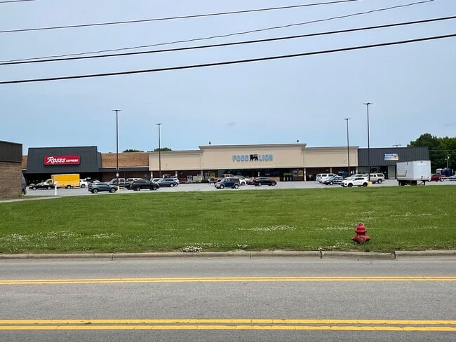
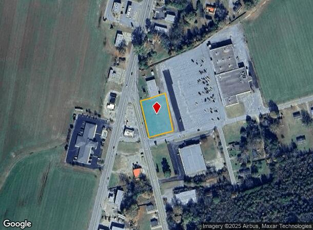
Property Detail
Highway 125 S
Roanoke Rapids, NC
Scotland Yard
11-03303
OUTPARCEL 2/HWY 125 - SCOTLAND NECK SHOPPING CENTER
Communitycenter
Halifax
X
North Carolina
3720486600J
0.86 AC
2024
North Carolina Northeast Area
2025
Other Market Areas
931101
DEMOGRAPHICS near Highway 125 S
1 Mile
3 Mile
5 Mile
2024 Total Population
1,512
3,209
3,790
2029 Population
1,547
3,208
3,769
Pop Growth 2024-2029
+ 2.31%
(0.03%)
(0.55%)
Average Age
47
46
46
2024 Total Households
667
1,403
1,651
HH Growth 2024-2029
+ 2.70%
+ 0.21%
(0.30%)
Median Household Inc
$19,694
$24,505
$26,223
Avg Household Size
2.10
2.20
2.20
2024 Avg HH Vehicles
1.00
2.00
2.00
Median Home Value
$62,752
$76,264
$79,180
Median Year Built
1965
1970
1970
Nearby Places
- Restaurants
- Banks
- Shops
- Fitness
- Groceries
Nearby Properties
Address
Land Use
TOTAL SIZE
Lot Size
Zoning
Address
Land Use
TOTAL SIZE
Lot Size
Zoning
37,640 SF
12.15 AC
SNR
Address
Land Use
TOTAL SIZE
Lot Size
Zoning
32,044 SF
20.54 AC
SNRA
Address
Land Use
TOTAL SIZE
Lot Size
Zoning
14,400 SF
17 AC
SNR
Address
Land Use
TOTAL SIZE
Lot Size
Zoning
26,968 SF
12.50 AC
CORA
Address
Land Use
TOTAL SIZE
Lot Size
Zoning
26,664 SF
10 AC
SNR
Address
Land Use
TOTAL SIZE
Lot Size
Zoning
3,420 SF
20 AC
SNI1
Address
Land Use
TOTAL SIZE
Lot Size
Zoning
26,850 SF
7.48 AC
SNRM
Address
Land Use
TOTAL SIZE
Lot Size
Zoning
14,066 SF
4.59 AC
SNB1
Address
Land Use
TOTAL SIZE
Lot Size
Zoning
1,650 SF
10.65 AC
SNR
Address
Land Use
TOTAL SIZE
Lot Size
Zoning
18,560 SF
10 AC
SNR
Address
Land Use
TOTAL SIZE
Lot Size
Zoning
5,474 SF
0.76 AC
SNR2
Address
Land Use
TOTAL SIZE
Lot Size
Zoning
14,490 SF
0.60 AC
SNR2
Address
Land Use
TOTAL SIZE
Lot Size
Zoning
15,144 SF
2.85 AC
SNR
Address
Land Use
TOTAL SIZE
Lot Size
Zoning
16,916 SF
0.65 AC
SNR2
Address
Land Use
TOTAL SIZE
Lot Size
Zoning
12,000 SF
12.48 AC
SNI1
Address
Land Use
TOTAL SIZE
Lot Size
Zoning
9,838 SF
0.92 AC
SNR1
Address
Land Use
TOTAL SIZE
Lot Size
Zoning
16,802 SF
1.93 AC
SNB2
Address
Land Use
TOTAL SIZE
Lot Size
Zoning
7,200 SF
2.20 AC
SNB2
Address
Land Use
TOTAL SIZE
Lot Size
Zoning
20,000 SF
2.67 AC
SNB2
Address
Land Use
TOTAL SIZE
Lot Size
Zoning
7,298 SF
0.67 AC
SNB1
Address
Land Use
TOTAL SIZE
Lot Size
Zoning
6,952 SF
8.59 AC
CORA
Address
Land Use
TOTAL SIZE
Lot Size
Zoning
9,266 SF
0.37 AC
SNB1
Address
Land Use
TOTAL SIZE
Lot Size
Zoning
4,684 SF
5.60 AC
CORA
Address
Land Use
TOTAL SIZE
Lot Size
Zoning
63,360 SF
8 AC
SNI1
Address
Land Use
TOTAL SIZE
Lot Size
Zoning
56,954 SF
5.06 AC
SNI2
Address
Land Use
TOTAL SIZE
Lot Size
Zoning
3,196 SF
1.61 AC
SNR
Address
Land Use
TOTAL SIZE
Lot Size
Zoning
1.07 AC
SNR
Address
Land Use
TOTAL SIZE
Lot Size
Zoning
4,320 SF
2.09 AC
CORA
Address
Land Use
TOTAL SIZE
Lot Size
Zoning
10,000 SF
12.88 AC
SNI2
Address
Land Use
TOTAL SIZE
Lot Size
Zoning
5,900 SF
0.92 AC
SNB1
The World's #1 Commercial Real Estate Marketplace
Connect with us
© 2025 CoStar Group
The information above has been obtained from sources believed reliable. While we do not doubt its accuracy we have not verified it and make no guarantee, warranty or representation about it. It is your responsibility to independently confirm its accuracy and completeness. Any projections, opinions, assumptions, or estimates used are for example only and do not represent the current or future performance of the property. The value of this transaction to you depends on tax and other factors which should be evaluated by your tax, financial, and legal advisors. You and your advisors should conduct a careful, independent investigation of the property to determine to your satisfaction the suitability of the property for your needs.