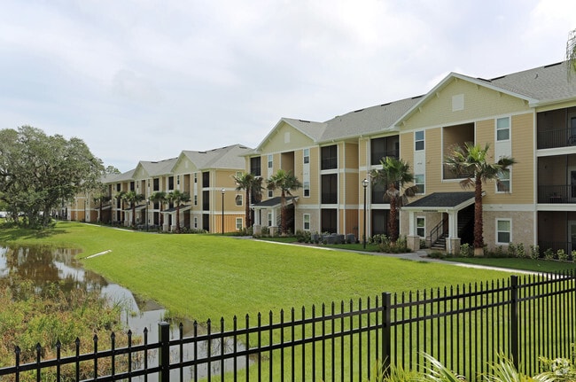
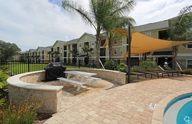
Property Record
Forest Gln, Daytona Beach, FL 32114
Property Detail
Forest Gln
Deltona-Daytona Beach-Ormond Beach, FL
40-15-33 LOTS 8 & 9 BLK 19 BETHUNE GRANT MB 1 PG 56 OR MB 12 PG 41 PER OR 4838 PG 3189 EXC S 682.24 FT MEAS ON W/L PER OR 5804 PG 1920 PER OR 6793 PG 0878 & OR 6885 PG 0609 PER OR 7029 PG 0315 PER OR 7029 PG 0319 PER OR 8771 PG 2688
5340-05-19-0032
VOLUSIA
Multifamilydwelling
Florida
B and X Area of moderate flood hazard, usually the area between the limits of the 100-year and 500-year floods.
8,9
2025
0.57 AC
2026
Bethune Grant
082100
Deltona/Daytona Beach
226,459 SF
NEARBY LISTINGS FOR SALE OR LEASE
DEMOGRAPHICS near Forest Gln
1 mile
3 mile
5 mile
2025 Total Population
8,380
71,093
148,295
2030 Population
8,759
76,296
160,037
Pop Growth 2025-2030
+ 4.52%
+ 7.32%
+ 7.92%
Average Age
34
41
44
2025 Total Households
2,665
30,255
66,139
HH Growth 2025-2030
+ 4.32%
+ 7.34%
+ 8.07%
Median Household Inc
$40,315
$49,556
$54,967
Avg Household Size
2.00
2.10
2.10
2025 Avg HH Vehicles
1.00
1.00
1.00
Median Home Value
$260,787
$224,466
$274,575
Median Year Built
1979
1979
1981
Nearby Places
Map Layers
Map Styles
 Street
 Aerial
Layers
 Traffic
 Biking
Places
Listings with unknown addresses are not visible on the map
- Restaurants
- Banks
- Shops
- Fitness
- Groceries
PUBLIC TRANSPORTATION
AIRPORT
Daytona Beach International
Drive
Walk
Distance
Daytona Beach International
7 min
2.4 mi
Freight Ports
Port Canaveral
Drive
Walk
Distance
Port Canaveral
86 min
70.0 mi
Nearby Properties
Address
Land Use
TOTAL SIZE
Lot Size
Zoning
Address
Land Use
TOTAL SIZE
Lot Size
Zoning
863,820 SF
374 AC
AP
Address
Land Use
TOTAL SIZE
Lot Size
Zoning
2,673,647 SF
110.95 AC
I12
Address
Land Use
TOTAL SIZE
Lot Size
Zoning
1,365,998 SF
13 AC
Address
Land Use
TOTAL SIZE
Lot Size
Zoning
1,842,969 SF
25.56 AC
Address
Land Use
TOTAL SIZE
Lot Size
Zoning
664,082 SF
38.16 AC
02BA
Address
Land Use
TOTAL SIZE
Lot Size
Zoning
1,058,116 SF
54.22 AC
Address
Land Use
TOTAL SIZE
Lot Size
Zoning
626,109 SF
72.96 AC
Address
Land Use
TOTAL SIZE
Lot Size
Zoning
490,775 SF
34.26 AC
01MH1
Address
Land Use
TOTAL SIZE
Lot Size
Zoning
223,127 SF
14.47 AC
Address
Land Use
TOTAL SIZE
Lot Size
Zoning
353,548 SF
50.65 AC
Address
Land Use
TOTAL SIZE
Lot Size
Zoning
442,125 SF
0.98 AC
A21
Address
Land Use
TOTAL SIZE
Lot Size
Zoning
396,385 SF
10 AC
01A2
Address
Land Use
TOTAL SIZE
Lot Size
Zoning
462,136 SF
31.84 AC
01A2
Address
Land Use
TOTAL SIZE
Lot Size
Zoning
13,965 SF
0.70 AC
MH1
Address
Land Use
TOTAL SIZE
Lot Size
Zoning
275,814 SF
13 AC
Address
Land Use
TOTAL SIZE
Lot Size
Zoning
286,461 SF
945.48 AC
B62
Address
Land Use
TOTAL SIZE
Lot Size
Zoning
197,581 SF
14.58 AC
Address
Land Use
TOTAL SIZE
Lot Size
Zoning
291,590 SF
11.68 AC
Address
Land Use
TOTAL SIZE
Lot Size
Zoning
300,038 SF
0.22 AC
Address
Land Use
TOTAL SIZE
Lot Size
Zoning
303,151 SF
13.58 AC
Address
Land Use
TOTAL SIZE
Lot Size
Zoning
330,883 SF
19.59 AC
Address
Land Use
TOTAL SIZE
Lot Size
Zoning
300,516 SF
70 AC
A2
Address
Land Use
TOTAL SIZE
Lot Size
Zoning
379,591 SF
21.62 AC
MH1
Address
Land Use
TOTAL SIZE
Lot Size
Zoning
306,467 SF
20.76 AC
Address
Land Use
TOTAL SIZE
Lot Size
Zoning
5,774 SF
0.94 AC
B4
Address
Land Use
TOTAL SIZE
Lot Size
Zoning
560,165 SF
37.79 AC
02BR2
Address
Land Use
TOTAL SIZE
Lot Size
Zoning
318,230 SF
21.28 AC
Address
Land Use
TOTAL SIZE
Lot Size
Zoning
12,871 SF
0.20 AC
R4
Address
Land Use
TOTAL SIZE
Lot Size
Zoning
207,607 SF
9.83 AC
The World's #1 Commercial Real Estate Marketplace
Connect with us
© 2026 CoStar Group
The information above has been obtained from sources believed reliable. While we do not doubt its accuracy we have not verified it and make no guarantee, warranty or representation about it. It is your responsibility to independently confirm its accuracy and completeness. Any projections, opinions, assumptions, or estimates used are for example only and do not represent the current or future performance of the property. The value of this transaction to you depends on tax and other factors which should be evaluated by your tax, financial, and legal advisors. You and your advisors should conduct a careful, independent investigation of the property to determine to your satisfaction the suitability of the property for your needs.