Property Record
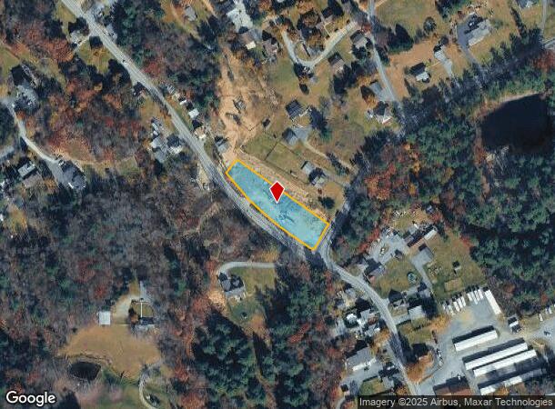
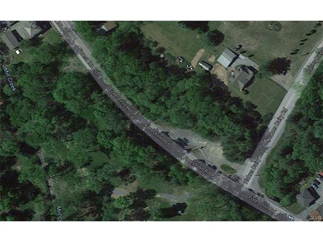
Forest Inn Hahns Dairy Rd, Palmerton, PA 18071

NEARBY LISTINGS FOR SALE OR LEASE
-
-
No Photo
-
View all Palmerton listings for sale on LoopNet.com
Property Detail
Forest Inn Hahns Dairy Rd
Allentown-Bethlehem-Easton, PA-NJ
Carbon
29C-33-27
Pennsylvania
Vacantlandnec
0.80 AC
2025
Lehigh Valley
2025
Philadelphia
020801
DEMOGRAPHICS near Forest Inn Hahns Dairy Rd
1 Mile
3 Mile
5 Mile
2024 Total Population
2,432
9,708
25,711
2029 Population
2,457
9,789
25,887
Pop Growth 2024-2029
+ 1.03%
+ 0.83%
+ 0.68%
Average Age
44
44
44
2024 Total Households
1,025
4,060
10,621
HH Growth 2024-2029
+ 1.07%
+ 0.89%
+ 0.72%
Median Household Inc
$68,245
$62,637
$64,181
Avg Household Size
2.40
2.40
2.40
2024 Avg HH Vehicles
2.00
2.00
2.00
Median Home Value
$169,834
$185,421
$198,015
Median Year Built
1959
1964
1968
Nearby Places
Map Layers
Map Styles
 Street
 Aerial
- Restaurants
- Banks
- Shops
- Fitness
- Groceries
PUBLIC TRANSPORTATION
AIRPORT
Lehigh Valley International
DRIVE
WALK
Distance
Lehigh Valley International
38 min
21.7 mi
SALE & LEASE HISTORY
LISTING DATE
SALE/LEASE

Sep 24, 2016
For Sale
Jun 10, 2019
For Sale
Nearby Properties
Address
Land Use
TOTAL SIZE
Lot Size
Zoning
Address
Land Use
TOTAL SIZE
Lot Size
Zoning
3,325 SF
55.50 AC
Address
Land Use
TOTAL SIZE
Lot Size
Zoning
1.05 AC
Address
Land Use
TOTAL SIZE
Lot Size
Zoning
816 SF
0.35 AC
Address
Land Use
TOTAL SIZE
Lot Size
Zoning
1,100 SF
40.77 AC
Address
Land Use
TOTAL SIZE
Lot Size
Zoning
44.92 AC
RA
Address
Land Use
TOTAL SIZE
Lot Size
Zoning
1,344 SF
3.56 AC
Address
Land Use
TOTAL SIZE
Lot Size
Zoning
137.56 AC
Address
Land Use
TOTAL SIZE
Lot Size
Zoning
682.58 AC
RA
Address
Land Use
TOTAL SIZE
Lot Size
Zoning
4,020 SF
25.30 AC
Address
Land Use
TOTAL SIZE
Lot Size
Zoning
1,240 SF
2.62 AC
Address
Land Use
TOTAL SIZE
Lot Size
Zoning
1,100 SF
8.01 AC
Address
Land Use
TOTAL SIZE
Lot Size
Zoning
0.35 AC
Address
Land Use
TOTAL SIZE
Lot Size
Zoning
14,080 SF
20.70 AC
Address
Land Use
TOTAL SIZE
Lot Size
Zoning
1,557 SF
1.34 AC
Address
Land Use
TOTAL SIZE
Lot Size
Zoning
9,680 SF
47.60 AC
I
Address
Land Use
TOTAL SIZE
Lot Size
Zoning
4,132 SF
5.10 AC
BM
Address
Land Use
TOTAL SIZE
Lot Size
Zoning
Address
Land Use
TOTAL SIZE
Lot Size
Zoning
2,168 SF
0.52 AC
Address
Land Use
TOTAL SIZE
Lot Size
Zoning
768 SF
0.85 AC
Address
Land Use
TOTAL SIZE
Lot Size
Zoning
1,066 SF
1.05 AC
Address
Land Use
TOTAL SIZE
Lot Size
Zoning
1,188 SF
0.68 AC
Address
Land Use
TOTAL SIZE
Lot Size
Zoning
9,289 SF
2.45 AC
RR
Address
Land Use
TOTAL SIZE
Lot Size
Zoning
76.58 AC
Address
Land Use
TOTAL SIZE
Lot Size
Zoning
1,176 SF
0.31 AC
Address
Land Use
TOTAL SIZE
Lot Size
Zoning
1,344 SF
0.57 AC
Address
Land Use
TOTAL SIZE
Lot Size
Zoning
4,582 SF
33.79 AC
Address
Land Use
TOTAL SIZE
Lot Size
Zoning
1,332 SF
1.47 AC
Address
Land Use
TOTAL SIZE
Lot Size
Zoning
1,288 SF
1.05 AC
Address
Land Use
TOTAL SIZE
Lot Size
Zoning
Address
Land Use
TOTAL SIZE
Lot Size
Zoning
1,508 SF
39.29 AC
The World's #1 Commercial Real Estate Marketplace
Connect with us
© 2025 CoStar Group
The information above has been obtained from sources believed reliable. While we do not doubt its accuracy we have not verified it and make no guarantee, warranty or representation about it. It is your responsibility to independently confirm its accuracy and completeness. Any projections, opinions, assumptions, or estimates used are for example only and do not represent the current or future performance of the property. The value of this transaction to you depends on tax and other factors which should be evaluated by your tax, financial, and legal advisors. You and your advisors should conduct a careful, independent investigation of the property to determine to your satisfaction the suitability of the property for your needs.