Property Record
Fort, Riverview, MI 48193
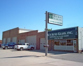
Property Detail
Fort
Detroit-Warren-Dearborn, MI
06K12 LOT 12 MYERDALE PARK SUB T4S R11E L60 P81 WCR
51-012-04-0013-000
WAYNE
Commercialnec
Michigan
B3-GEN
12
B and X Area of moderate flood hazard, usually the area between the limits of the 100-year and 500-year floods.
0.05 AC
2025
Downriver South
2025
Detroit
595100
NEARBY LISTINGS FOR SALE OR LEASE
DEMOGRAPHICS near Fort
1 mile
3 mile
5 mile
2025 Total Population
10,642
69,278
159,956
2030 Population
10,410
67,773
156,897
Pop Growth 2025-2030
(2.18%)
(2.17%)
(1.91%)
Average Age
43
44
42
2025 Total Households
4,756
30,240
67,646
HH Growth 2025-2030
(2.27%)
(2.21%)
(1.95%)
Median Household Inc
$64,613
$72,576
$72,241
Avg Household Size
2.10
2.20
2.30
2025 Avg HH Vehicles
2.00
2.00
2.00
Median Home Value
$185,003
$192,765
$186,903
Median Year Built
1964
1958
1960
Nearby Places
Map Layers
Map Styles
 Street
 Aerial
Layers
 Traffic
 Biking
Places
Listings with unknown addresses are not visible on the map
- Restaurants
- Banks
- Shops
- Fitness
- Groceries
PUBLIC TRANSPORTATION
AIRPORT
Detroit Metro Wayne County
Drive
Walk
Distance
Detroit Metro Wayne County
21 min
12.4 mi
Windsor International
Drive
Walk
Distance
Windsor International
44 min
23.8 mi
Freight Ports
Port of Toledo
Drive
Walk
Distance
Port of Toledo
61 min
45.6 mi
Nearby Properties
Address
Land Use
TOTAL SIZE
Lot Size
Zoning
Address
Land Use
TOTAL SIZE
Lot Size
Zoning
2,651,867 SF
137.23 AC
I-3
Address
Land Use
TOTAL SIZE
Lot Size
Zoning
1,981,391 SF
166.35 AC
I-2
Address
Land Use
TOTAL SIZE
Lot Size
Zoning
1,606,527 SF
126.47 AC
I-2
Address
Land Use
TOTAL SIZE
Lot Size
Zoning
479,851 SF
16.90 AC
RM MULTI F
Address
Land Use
TOTAL SIZE
Lot Size
Zoning
729,040 SF
45.85 AC
I-2
Address
Land Use
TOTAL SIZE
Lot Size
Zoning
125,898 SF
10.62 AC
B-2
Address
Land Use
TOTAL SIZE
Lot Size
Zoning
125,898 SF
10.62 AC
B-2
Address
Land Use
TOTAL SIZE
Lot Size
Zoning
247,238 SF
21.39 AC
I-1
Address
Land Use
TOTAL SIZE
Lot Size
Zoning
262,170 SF
15.27 AC
RM MULTI F
Address
Land Use
TOTAL SIZE
Lot Size
Zoning
220,869 SF
25.31 AC
C-2 GEN BU
Address
Land Use
TOTAL SIZE
Lot Size
Zoning
10.66 AC
RM MULTI F
Address
Land Use
TOTAL SIZE
Lot Size
Zoning
252,833 SF
34.40 AC
RM1-MUL
Address
Land Use
TOTAL SIZE
Lot Size
Zoning
240,852 SF
15.44 AC
RM MULTI F
Address
Land Use
TOTAL SIZE
Lot Size
Zoning
217,548 SF
6.82 AC
RM MULTI F
Address
Land Use
TOTAL SIZE
Lot Size
Zoning
2,160 SF
334.88 AC
I1
Address
Land Use
TOTAL SIZE
Lot Size
Zoning
84,860 SF
9.13 AC
C-2 GEN BU
Address
Land Use
TOTAL SIZE
Lot Size
Zoning
143,496 SF
3.73 AC
RM-2
Address
Land Use
TOTAL SIZE
Lot Size
Zoning
148,815 SF
9.11 AC
RM MULTI F
Address
Land Use
TOTAL SIZE
Lot Size
Zoning
209,412 SF
13.63 AC
C-2 GEN BU
Address
Land Use
TOTAL SIZE
Lot Size
Zoning
187,000 SF
16.81 AC
C-3 THOROF
Address
Land Use
TOTAL SIZE
Lot Size
Zoning
202,349 SF
14.33 AC
RM MULTI F
Address
Land Use
TOTAL SIZE
Lot Size
Zoning
255,456 SF
7.74 AC
I-1
Address
Land Use
TOTAL SIZE
Lot Size
Zoning
230,789 SF
9.98 AC
Address
Land Use
TOTAL SIZE
Lot Size
Zoning
130,968 SF
0.84 AC
Address
Land Use
TOTAL SIZE
Lot Size
Zoning
301,644 SF
14.22 AC
I-1
Address
Land Use
TOTAL SIZE
Lot Size
Zoning
121,186 SF
9.48 AC
C-3 THOROF
Address
Land Use
TOTAL SIZE
Lot Size
Zoning
71,336 SF
4.32 AC
C-2 GEN BU
Address
Land Use
TOTAL SIZE
Lot Size
Zoning
135,054 SF
17.58 AC
C-2 GEN BU
Address
Land Use
TOTAL SIZE
Lot Size
Zoning
498,367 SF
R1-SING
Address
Land Use
TOTAL SIZE
Lot Size
Zoning
74,362 SF
6.94 AC
RM1-MUL
The World's #1 Commercial Real Estate Marketplace
Connect with us
© 2026 CoStar Group
The information above has been obtained from sources believed reliable. While we do not doubt its accuracy we have not verified it and make no guarantee, warranty or representation about it. It is your responsibility to independently confirm its accuracy and completeness. Any projections, opinions, assumptions, or estimates used are for example only and do not represent the current or future performance of the property. The value of this transaction to you depends on tax and other factors which should be evaluated by your tax, financial, and legal advisors. You and your advisors should conduct a careful, independent investigation of the property to determine to your satisfaction the suitability of the property for your needs.