Property Record
Foster Rd, San Antonio, TX 78244
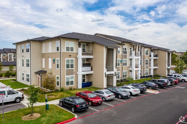

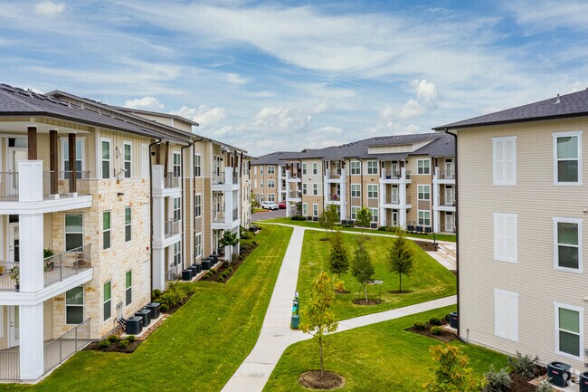
Property Detail
Foster Rd
San Antonio-New Braunfels, TX
NCB 16611 (FOSTER ROAD APARTMENTS), BLOCK 50 LOT 6 2018-CREATED PER PLAT 9717/82-88 FILED 06-23-2017
16611-050-0060
BEXAR
Multifamilydwelling
Texas
B and X Area of moderate flood hazard, usually the area between the limits of the 100-year and 500-year floods.
6
0
13.39 AC
2025
Sunrise
131615
San Antonio
278,406 SF
NEARBY LISTINGS FOR SALE OR LEASE
DEMOGRAPHICS near Foster Rd
1 mile
3 mile
5 mile
2025 Total Population
16,341
104,393
221,553
2030 Population
17,002
109,993
233,868
Pop Growth 2025-2030
+ 4.05%
+ 5.36%
+ 5.56%
Average Age
35
36
37
2025 Total Households
5,364
34,923
78,173
HH Growth 2025-2030
+ 4.16%
+ 5.45%
+ 5.61%
Median Household Inc
$69,614
$68,318
$68,232
Avg Household Size
2.90
2.90
2.70
2025 Avg HH Vehicles
2.00
2.00
2.00
Median Home Value
$218,799
$221,129
$234,979
Median Year Built
2001
1993
1989
Nearby Places
Map Layers
Map Styles
 Street
 Aerial
Layers
 Traffic
 Biking
Places
Listings with unknown addresses are not visible on the map
- Restaurants
- Banks
- Shops
- Fitness
- Groceries
PUBLIC TRANSPORTATION
COMMUTER RAIL
San Antonio Amtrak Station (Sunset Limited - Amtrak, Texas Eagle - Amtrak)
Drive
Walk
Distance
San Antonio Amtrak Station (Sunset Limited - Amtrak, Texas Eagle - Amtrak)
15 min
9.7 mi
AIRPORT
San Antonio International
Drive
Walk
Distance
San Antonio International
17 min
9.4 mi
Freight Ports
Calhoun Port
Drive
Walk
Distance
Calhoun Port
175 min
144.5 mi
Nearby Properties
Address
Land Use
TOTAL SIZE
Lot Size
Zoning
Address
Land Use
TOTAL SIZE
Lot Size
Zoning
1,649,488 SF
70 AC
Address
Land Use
TOTAL SIZE
Lot Size
Zoning
116,536 SF
13.84 AC
Address
Land Use
TOTAL SIZE
Lot Size
Zoning
435,592 SF
31.43 AC
Address
Land Use
TOTAL SIZE
Lot Size
Zoning
110,605 SF
19.95 AC
Address
Land Use
TOTAL SIZE
Lot Size
Zoning
249,633 SF
7.04 AC
Address
Land Use
TOTAL SIZE
Lot Size
Zoning
598,070 SF
46.05 AC
Address
Land Use
TOTAL SIZE
Lot Size
Zoning
387,440 SF
27.71 AC
Address
Land Use
TOTAL SIZE
Lot Size
Zoning
328,605 SF
25.69 AC
Address
Land Use
TOTAL SIZE
Lot Size
Zoning
457,302 SF
34.40 AC
Address
Land Use
TOTAL SIZE
Lot Size
Zoning
230,659 SF
15.48 AC
Address
Land Use
TOTAL SIZE
Lot Size
Zoning
74.65 AC
Address
Land Use
TOTAL SIZE
Lot Size
Zoning
273,516 SF
17.50 AC
Address
Land Use
TOTAL SIZE
Lot Size
Zoning
132.44 AC
Address
Land Use
TOTAL SIZE
Lot Size
Zoning
337,468 SF
21.84 AC
Address
Land Use
TOTAL SIZE
Lot Size
Zoning
325,434 SF
21.47 AC
Address
Land Use
TOTAL SIZE
Lot Size
Zoning
222,865 SF
17.75 AC
Address
Land Use
TOTAL SIZE
Lot Size
Zoning
431,326 SF
42.70 AC
Address
Land Use
TOTAL SIZE
Lot Size
Zoning
280,365 SF
17.72 AC
Address
Land Use
TOTAL SIZE
Lot Size
Zoning
437,807 SF
24.55 AC
Address
Land Use
TOTAL SIZE
Lot Size
Zoning
258,063 SF
24.55 AC
Address
Land Use
TOTAL SIZE
Lot Size
Zoning
391,863 SF
24.43 AC
Address
Land Use
TOTAL SIZE
Lot Size
Zoning
306,000 SF
20.23 AC
Address
Land Use
TOTAL SIZE
Lot Size
Zoning
15.42 AC
Address
Land Use
TOTAL SIZE
Lot Size
Zoning
251,680 SF
15.52 AC
Address
Land Use
TOTAL SIZE
Lot Size
Zoning
224,840 SF
17.27 AC
Address
Land Use
TOTAL SIZE
Lot Size
Zoning
199,280 SF
11.50 AC
Address
Land Use
TOTAL SIZE
Lot Size
Zoning
467,359 SF
34.88 AC
Address
Land Use
TOTAL SIZE
Lot Size
Zoning
144,814 SF
8.18 AC
Address
Land Use
TOTAL SIZE
Lot Size
Zoning
176,907 SF
12.73 AC
The World's #1 Commercial Real Estate Marketplace
Connect with us
© 2026 CoStar Group
The information above has been obtained from sources believed reliable. While we do not doubt its accuracy we have not verified it and make no guarantee, warranty or representation about it. It is your responsibility to independently confirm its accuracy and completeness. Any projections, opinions, assumptions, or estimates used are for example only and do not represent the current or future performance of the property. The value of this transaction to you depends on tax and other factors which should be evaluated by your tax, financial, and legal advisors. You and your advisors should conduct a careful, independent investigation of the property to determine to your satisfaction the suitability of the property for your needs.