Property Record
0 Fox Rd, Hughson, CA 95326


Property Detail
0 Fox Rd
Modesto, CA
STANISLAUS
018-22-31
California
Residentialacreage
4
B and X Area of moderate flood hazard, usually the area between the limits of the 100-year and 500-year floods.
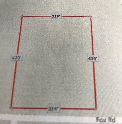
3.08 AC
2025
Hughson/Oakdale/Waterford
2025
Stockton/Modesto
002903
NEARBY LISTINGS FOR SALE OR LEASE
DEMOGRAPHICS near 0 Fox Rd
1 mile
3 mile
5 mile
2024 Total Population
6,212
10,747
50,450
2029 Population
6,153
10,721
50,331
Pop Growth 2024-2029
(0.95%)
(0.24%)
(0.24%)
Average Age
38
38
37
2024 Total Households
2,041
3,509
15,019
HH Growth 2024-2029
(0.44%)
(0.11%)
(0.27%)
Median Household Inc
$102,003
$98,340
$90,841
Avg Household Size
3.10
3.10
3.30
2024 Avg HH Vehicles
2.00
2.00
2.00
Median Home Value
$591,544
$625,806
$496,948
Median Year Built
1990
1987
1989
Nearby Places
Map Layers
Map Styles
 Street
 Aerial
Transit
 Traffic
 Biking
Places
Listings with unknown addresses are not visible on the map
- Restaurants
- Banks
- Shops
- Fitness
- Groceries
PUBLIC TRANSPORTATION
AIRPORT
Stockton Metro
Drive
Walk
Distance
Stockton Metro
49 min
34.5 mi
Freight Ports
Port of Stockton
Drive
Walk
Distance
Port of Stockton
57 min
43.0 mi
SALE & LEASE HISTORY
LISTING DATE
SALE/LEASE

Jun 01, 2017
For Sale
Nearby Properties
Address
Land Use
TOTAL SIZE
Lot Size
Zoning
Address
Land Use
TOTAL SIZE
Lot Size
Zoning
248,742 SF
15.94 AC
PC
Address
Land Use
TOTAL SIZE
Lot Size
Zoning
26,592 SF
77.55 AC
Address
Land Use
TOTAL SIZE
Lot Size
Zoning
924 SF
19.46 AC
A240
Address
Land Use
TOTAL SIZE
Lot Size
Zoning
10.70 AC
A240
Address
Land Use
TOTAL SIZE
Lot Size
Zoning
124,212 SF
13.51 AC
HUGC2
Address
Land Use
TOTAL SIZE
Lot Size
Zoning
1,920 SF
38.18 AC
Address
Land Use
TOTAL SIZE
Lot Size
Zoning
72,885 SF
10.70 AC
COUPD
Address
Land Use
TOTAL SIZE
Lot Size
Zoning
19,972 SF
2.15 AC
PC
Address
Land Use
TOTAL SIZE
Lot Size
Zoning
5,139 SF
30.80 AC
A240
Address
Land Use
TOTAL SIZE
Lot Size
Zoning
37.72 AC
Address
Land Use
TOTAL SIZE
Lot Size
Zoning
34.20 AC
A240
Address
Land Use
TOTAL SIZE
Lot Size
Zoning
20,491 SF
31.12 AC
COUPD
Address
Land Use
TOTAL SIZE
Lot Size
Zoning
149.30 AC
Address
Land Use
TOTAL SIZE
Lot Size
Zoning
70,606 SF
8.19 AC
Address
Land Use
TOTAL SIZE
Lot Size
Zoning
8,063 SF
95.70 AC
A240
Address
Land Use
TOTAL SIZE
Lot Size
Zoning
29,975 SF
11.25 AC
Address
Land Use
TOTAL SIZE
Lot Size
Zoning
11.58 AC
Address
Land Use
TOTAL SIZE
Lot Size
Zoning
22,701 SF
6.61 AC
Address
Land Use
TOTAL SIZE
Lot Size
Zoning
102.23 AC
A240
Address
Land Use
TOTAL SIZE
Lot Size
Zoning
47,549 SF
5.86 AC
Address
Land Use
TOTAL SIZE
Lot Size
Zoning
2,166 SF
311.29 AC
A240
Address
Land Use
TOTAL SIZE
Lot Size
Zoning
22.83 AC
HUGI
Address
Land Use
TOTAL SIZE
Lot Size
Zoning
928 SF
30.93 AC
A240
Address
Land Use
TOTAL SIZE
Lot Size
Zoning
37,878 SF
2.23 AC
HUGI
Address
Land Use
TOTAL SIZE
Lot Size
Zoning
2,148 SF
11.49 AC
Address
Land Use
TOTAL SIZE
Lot Size
Zoning
1,514 SF
35.78 AC
A240
Address
Land Use
TOTAL SIZE
Lot Size
Zoning
8,412 SF
92.67 AC
A240
Address
Land Use
TOTAL SIZE
Lot Size
Zoning
2,572 SF
43.65 AC
Address
Land Use
TOTAL SIZE
Lot Size
Zoning
1,408 SF
31.67 AC
A240
Address
Land Use
TOTAL SIZE
Lot Size
Zoning
31,000 SF
9.81 AC
The World's #1 Commercial Real Estate Marketplace
Connect with us
© 2026 CoStar Group
The information above has been obtained from sources believed reliable. While we do not doubt its accuracy we have not verified it and make no guarantee, warranty or representation about it. It is your responsibility to independently confirm its accuracy and completeness. Any projections, opinions, assumptions, or estimates used are for example only and do not represent the current or future performance of the property. The value of this transaction to you depends on tax and other factors which should be evaluated by your tax, financial, and legal advisors. You and your advisors should conduct a careful, independent investigation of the property to determine to your satisfaction the suitability of the property for your needs.