Property Record
2727 Highway 52, Moncks Corner, SC 29461
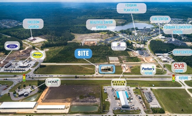
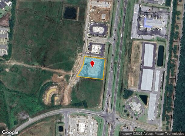
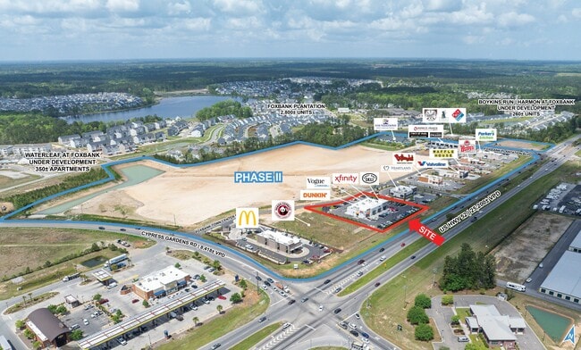
This Property Is For Sale
NEARBY LISTINGS FOR SALE OR LEASE
Property Detail
2727 Highway 52
Charleston-North Charleston, SC
Foxbank
197-00-01-114
0.124 AC, PARCEL 5 (11/2022)
Restaurantdrivein
Berkeley
2025
South Carolina
2025
1.24 AC
020707
Outlying Berkeley County
7,810 SF
Charleston/N Charleston
DEMOGRAPHICS near 2727 Highway 52
1 Mile
3 Mile
5 Mile
2024 Total Population
4,122
15,393
52,883
2029 Population
4,862
18,147
62,381
Pop Growth 2024-2029
+ 17.95%
+ 17.89%
+ 17.96%
Average Age
35
35
37
2024 Total Households
1,393
5,270
19,153
HH Growth 2024-2029
+ 18.02%
+ 17.95%
+ 18.02%
Median Household Inc
$94,575
$87,160
$79,063
Avg Household Size
2.90
2.90
2.70
2024 Avg HH Vehicles
3.00
2.00
2.00
Median Home Value
$304,941
$286,462
$271,868
Median Year Built
2010
2010
2009
Nearby Places
Map Layers
Map Styles
 Street
 Aerial
- Restaurants
- Banks
- Shops
- Fitness
- Groceries
PUBLIC TRANSPORTATION
AIRPORT
Charleston AFB/International
DRIVE
WALK
Distance
Charleston AFB/International
26 min
17.4 mi
Freight Ports
North Charleston Terminal
DRIVE
WALK
Distance
North Charleston Terminal
20 min
15.8 mi
Nearby Properties
Address
Land Use
TOTAL SIZE
Lot Size
Zoning
Address
Land Use
TOTAL SIZE
Lot Size
Zoning
2,600 SF
26.39 AC
MONCKS COR
Address
Land Use
TOTAL SIZE
Lot Size
Zoning
55,363 SF
9.13 AC
MONCKS COR
Address
Land Use
TOTAL SIZE
Lot Size
Zoning
264,200 SF
47.96 AC
BERKELEY C
Address
Land Use
TOTAL SIZE
Lot Size
Zoning
236,940 SF
27.43 AC
BERKELEY C
Address
Land Use
TOTAL SIZE
Lot Size
Zoning
113,661 SF
21.93 AC
BERKELEY C
Address
Land Use
TOTAL SIZE
Lot Size
Zoning
135,200 SF
13.53 AC
BERKELEY C
Address
Land Use
TOTAL SIZE
Lot Size
Zoning
200,772 SF
30.94 AC
BERKELEY C
Address
Land Use
TOTAL SIZE
Lot Size
Zoning
93,800 SF
15 AC
BERKELEY C
Address
Land Use
TOTAL SIZE
Lot Size
Zoning
83,500 SF
6 AC
BERKELEY C
Address
Land Use
TOTAL SIZE
Lot Size
Zoning
54,600 SF
21.23 AC
BERKELEY C
Address
Land Use
TOTAL SIZE
Lot Size
Zoning
2,464.94 AC
BERKELEY C
Address
Land Use
TOTAL SIZE
Lot Size
Zoning
18,200 SF
6 AC
MONCKS COR
Address
Land Use
TOTAL SIZE
Lot Size
Zoning
100,440 SF
15 AC
BERKELEY C
Address
Land Use
TOTAL SIZE
Lot Size
Zoning
40.32 AC
BERKELEY C
Address
Land Use
TOTAL SIZE
Lot Size
Zoning
85,325 SF
28.95 AC
BERKELEY C
Address
Land Use
TOTAL SIZE
Lot Size
Zoning
35.23 AC
BERKELEY C
Address
Land Use
TOTAL SIZE
Lot Size
Zoning
32.84 AC
BERKELEY C
Address
Land Use
TOTAL SIZE
Lot Size
Zoning
20,393 SF
50.95 AC
BERKELEY C
Address
Land Use
TOTAL SIZE
Lot Size
Zoning
12,100 SF
5.26 AC
BERKELEY C
Address
Land Use
TOTAL SIZE
Lot Size
Zoning
45,081 SF
6.97 AC
MONCKS COR
Address
Land Use
TOTAL SIZE
Lot Size
Zoning
24.16 AC
BERKELEY C
Address
Land Use
TOTAL SIZE
Lot Size
Zoning
31,550 SF
22.54 AC
BERKELEY C
Address
Land Use
TOTAL SIZE
Lot Size
Zoning
84.02 AC
MONCKS COR
Address
Land Use
TOTAL SIZE
Lot Size
Zoning
5,096 SF
10.76 AC
BERKELEY C
Address
Land Use
TOTAL SIZE
Lot Size
Zoning
4,329 SF
1.27 AC
MONCKS COR
Address
Land Use
TOTAL SIZE
Lot Size
Zoning
70,000 SF
7.13 AC
BERKELEY C
Address
Land Use
TOTAL SIZE
Lot Size
Zoning
387.64 AC
BERKELEY C
Address
Land Use
TOTAL SIZE
Lot Size
Zoning
13,346 SF
17.03 AC
MONCKS COR
Address
Land Use
TOTAL SIZE
Lot Size
Zoning
103,000 SF
16.07 AC
BERKELEY C
The World's #1 Commercial Real Estate Marketplace
Connect with us
© 2025 CoStar Group
The information above has been obtained from sources believed reliable. While we do not doubt its accuracy we have not verified it and make no guarantee, warranty or representation about it. It is your responsibility to independently confirm its accuracy and completeness. Any projections, opinions, assumptions, or estimates used are for example only and do not represent the current or future performance of the property. The value of this transaction to you depends on tax and other factors which should be evaluated by your tax, financial, and legal advisors. You and your advisors should conduct a careful, independent investigation of the property to determine to your satisfaction the suitability of the property for your needs.