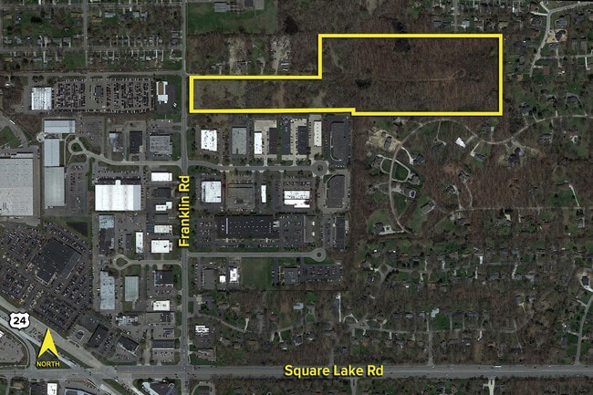
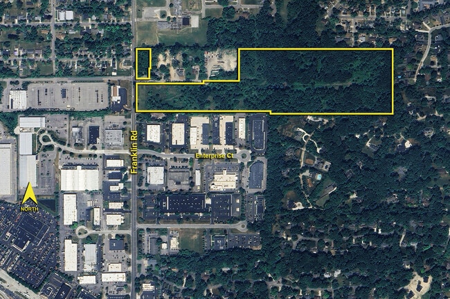
Property Record
Franklin Rd, Bloomfield Hills, MI 48302

Property Detail
Franklin Rd
Detroit-Warren-Dearborn, MI
T2N, R10E, SEC 4 SUPERVISOR'S PLAT NO. 1 LOT 10, ALSO VAC LOT 30 ADJ TO SAME 1-5-2021 CORR
19-04-302-004
OAKLAND
Commercialacreage
Michigan
IV
10,30
B and X Area of moderate flood hazard, usually the area between the limits of the 100-year and 500-year floods.
0.15 AC
2024
Pontiac
2025
Detroit
150200
NEARBY LISTINGS FOR SALE OR LEASE
DEMOGRAPHICS near Franklin Rd
1 mile
3 mile
5 mile
2025 Total Population
11,999
69,879
171,448
2030 Population
13,180
72,995
176,931
Pop Growth 2025-2030
+ 9.84%
+ 4.46%
+ 3.20%
Average Age
40
41
41
2025 Total Households
4,685
27,987
68,373
HH Growth 2025-2030
+ 9.63%
+ 4.41%
+ 3.27%
Median Household Inc
$39,174
$67,503
$76,259
Avg Household Size
2.50
2.40
2.40
2025 Avg HH Vehicles
1.00
2.00
2.00
Median Home Value
$158,295
$280,574
$353,706
Median Year Built
1975
1967
1968
Nearby Places
Map Layers
Map Styles
 Street
 Aerial
Layers
 Traffic
 Biking
Places
Listings with unknown addresses are not visible on the map
- Restaurants
- Banks
- Shops
- Fitness
- Groceries
PUBLIC TRANSPORTATION
COMMUTER RAIL
Pontiac Amtrak Station (Wolverine - Amtrak)
Drive
Walk
Distance
Pontiac Amtrak Station (Wolverine - Amtrak)
5 min
2.5 mi
Troy Amtrak Station (Wolverine - Amtrak)
Drive
Walk
Distance
Troy Amtrak Station (Wolverine - Amtrak)
16 min
8.2 mi
AIRPORT
Windsor International
Drive
Walk
Distance
Windsor International
57 min
38.4 mi
Detroit Metro Wayne County
Drive
Walk
Distance
Detroit Metro Wayne County
54 min
41.6 mi
Freight Ports
Port of Toledo
Drive
Walk
Distance
Port of Toledo
104 min
83.2 mi
SALE & LEASE HISTORY
LISTING DATE
SALE/LEASE

Sep 08, 2017
For Sale
Sep 04, 2017
For Sale
Aug 19, 2020
For Sale
Nearby Properties
Address
Land Use
TOTAL SIZE
Lot Size
Zoning
Address
Land Use
TOTAL SIZE
Lot Size
Zoning
2,734,739 SF
80.39 AC
Address
Land Use
TOTAL SIZE
Lot Size
Zoning
526,398 SF
32.99 AC
Address
Land Use
TOTAL SIZE
Lot Size
Zoning
711,360 SF
43.86 AC
Address
Land Use
TOTAL SIZE
Lot Size
Zoning
608,251 SF
50.49 AC
II
Address
Land Use
TOTAL SIZE
Lot Size
Zoning
374,400 SF
4.10 AC
Address
Land Use
TOTAL SIZE
Lot Size
Zoning
601,151 SF
Address
Land Use
TOTAL SIZE
Lot Size
Zoning
360,186 SF
38.44 AC
RM2
Address
Land Use
TOTAL SIZE
Lot Size
Zoning
289,110 SF
6.07 AC
BI
Address
Land Use
TOTAL SIZE
Lot Size
Zoning
101,409 SF
5.90 AC
Address
Land Use
TOTAL SIZE
Lot Size
Zoning
206,590 SF
6.14 AC
RI
Address
Land Use
TOTAL SIZE
Lot Size
Zoning
221,340 SF
26.88 AC
BI
Address
Land Use
TOTAL SIZE
Lot Size
Zoning
203,643 SF
9.85 AC
IV
Address
Land Use
TOTAL SIZE
Lot Size
Zoning
205,703 SF
21.63 AC
B2
Address
Land Use
TOTAL SIZE
Lot Size
Zoning
242,512 SF
6.60 AC
BI
Address
Land Use
TOTAL SIZE
Lot Size
Zoning
156,668 SF
13.19 AC
BI
Address
Land Use
TOTAL SIZE
Lot Size
Zoning
23.28 AC
AI
Address
Land Use
TOTAL SIZE
Lot Size
Zoning
454,573 SF
Address
Land Use
TOTAL SIZE
Lot Size
Zoning
97,172 SF
13.82 AC
BI
Address
Land Use
TOTAL SIZE
Lot Size
Zoning
267,393 SF
11.11 AC
BI
Address
Land Use
TOTAL SIZE
Lot Size
Zoning
903,018 SF
73.92 AC
II
Address
Land Use
TOTAL SIZE
Lot Size
Zoning
58,661 SF
3.31 AC
BI
Address
Land Use
TOTAL SIZE
Lot Size
Zoning
288,124 SF
15.76 AC
Address
Land Use
TOTAL SIZE
Lot Size
Zoning
145,712 SF
10.51 AC
BV
Address
Land Use
TOTAL SIZE
Lot Size
Zoning
87,560 SF
7.94 AC
BI
Address
Land Use
TOTAL SIZE
Lot Size
Zoning
53,379 SF
139.07 AC
Address
Land Use
TOTAL SIZE
Lot Size
Zoning
157,589 SF
5.21 AC
Address
Land Use
TOTAL SIZE
Lot Size
Zoning
219,274 SF
9.75 AC
BI
Address
Land Use
TOTAL SIZE
Lot Size
Zoning
71,588 SF
3.72 AC
BI
Address
Land Use
TOTAL SIZE
Lot Size
Zoning
67,413 SF
4.32 AC
BI
Address
Land Use
TOTAL SIZE
Lot Size
Zoning
55,912 SF
1.11 AC
The World's #1 Commercial Real Estate Marketplace
Connect with us
© 2026 CoStar Group
The information above has been obtained from sources believed reliable. While we do not doubt its accuracy we have not verified it and make no guarantee, warranty or representation about it. It is your responsibility to independently confirm its accuracy and completeness. Any projections, opinions, assumptions, or estimates used are for example only and do not represent the current or future performance of the property. The value of this transaction to you depends on tax and other factors which should be evaluated by your tax, financial, and legal advisors. You and your advisors should conduct a careful, independent investigation of the property to determine to your satisfaction the suitability of the property for your needs.