Property Record
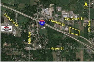
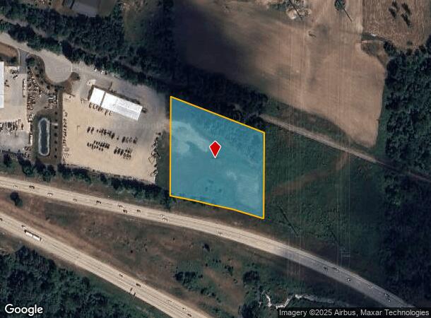
Franklin St, Marne, MI 49435
NEARBY LISTINGS FOR SALE OR LEASE
Property Detail
Franklin St
70-06-35-400-059
THAT PART OF W 39469 FT OF E 1331 FT OF SE 1/4 LYING S OF GTRR & N OF I-96 SEC 35 T8N R13W
Commercialacreage
Ottawa
X
Michigan
26081C0270D
3.38 AC
2024
Northern Ottawa County
2025
West Michigan
021402
Grand Rapids-Wyoming, MI
DEMOGRAPHICS near Franklin St
1 Mile
3 Mile
5 Mile
2024 Total Population
945
8,488
28,729
2029 Population
984
8,712
29,441
Pop Growth 2024-2029
+ 4.13%
+ 2.64%
+ 2.48%
Average Age
40
40
40
2024 Total Households
359
3,215
11,006
HH Growth 2024-2029
+ 4.18%
+ 2.86%
+ 2.44%
Median Household Inc
$69,687
$72,141
$77,069
Avg Household Size
2.60
2.60
2.60
2024 Avg HH Vehicles
2.00
2.00
2.00
Median Home Value
$312,319
$279,411
$267,293
Median Year Built
1971
1984
1985
Nearby Places
Map Layers
Map Styles
 Street
 Aerial
- Restaurants
- Banks
- Shops
- Fitness
- Groceries
PUBLIC TRANSPORTATION
AIRPORT
Gerald R Ford International
DRIVE
WALK
Distance
Gerald R Ford International
34 min
26.3 mi
Freight Ports
Port Milwaukee
DRIVE
WALK
Distance
Port Milwaukee
312 min
266.8 mi
SALE & LEASE HISTORY
LISTING DATE
SALE/LEASE

Sep 29, 2016
For Sale
Sep 24, 2016
For Sale
Nov 17, 2016
For Sale
Nearby Properties
Address
Land Use
TOTAL SIZE
Lot Size
Zoning
Address
Land Use
TOTAL SIZE
Lot Size
Zoning
410,206 SF
54.36 AC
MH
Address
Land Use
TOTAL SIZE
Lot Size
Zoning
198,000 SF
NOT APP
Address
Land Use
TOTAL SIZE
Lot Size
Zoning
132,680 SF
17.24 AC
IPUD
Address
Land Use
TOTAL SIZE
Lot Size
Zoning
162,765 SF
22.63 AC
MP
Address
Land Use
TOTAL SIZE
Lot Size
Zoning
59.89 AC
R-4
Address
Land Use
TOTAL SIZE
Lot Size
Zoning
247,168 SF
9.60 AC
MP
Address
Land Use
TOTAL SIZE
Lot Size
Zoning
140,841 SF
8.96 AC
Address
Land Use
TOTAL SIZE
Lot Size
Zoning
285,000 SF
17.66 AC
MH
Address
Land Use
TOTAL SIZE
Lot Size
Zoning
197,220 SF
10.94 AC
MP
Address
Land Use
TOTAL SIZE
Lot Size
Zoning
222,833 SF
20.49 AC
MH
Address
Land Use
TOTAL SIZE
Lot Size
Zoning
85,472 SF
12.17 AC
ARM - MULT
Address
Land Use
TOTAL SIZE
Lot Size
Zoning
104,000 SF
NOT APP
Address
Land Use
TOTAL SIZE
Lot Size
Zoning
200,000 SF
13.41 AC
MP
Address
Land Use
TOTAL SIZE
Lot Size
Zoning
119,000 SF
7.73 AC
IPUD
Address
Land Use
TOTAL SIZE
Lot Size
Zoning
121,584 SF
21.98 AC
I
Address
Land Use
TOTAL SIZE
Lot Size
Zoning
195,000 SF
11.09 AC
MP
Address
Land Use
TOTAL SIZE
Lot Size
Zoning
88,113 SF
12.50 AC
Address
Land Use
TOTAL SIZE
Lot Size
Zoning
162,020 SF
20 AC
MH
Address
Land Use
TOTAL SIZE
Lot Size
Zoning
43,864 SF
NOT APP
Address
Land Use
TOTAL SIZE
Lot Size
Zoning
89,277 SF
5.06 AC
MP
Address
Land Use
TOTAL SIZE
Lot Size
Zoning
4.80 AC
Address
Land Use
TOTAL SIZE
Lot Size
Zoning
Address
Land Use
TOTAL SIZE
Lot Size
Zoning
71,798 SF
8.51 AC
ML
Address
Land Use
TOTAL SIZE
Lot Size
Zoning
Address
Land Use
TOTAL SIZE
Lot Size
Zoning
59.31 AC
Address
Land Use
TOTAL SIZE
Lot Size
Zoning
Address
Land Use
TOTAL SIZE
Lot Size
Zoning
65,562 SF
8.18 AC
Address
Land Use
TOTAL SIZE
Lot Size
Zoning
73,887 SF
7.30 AC
MP
Address
Land Use
TOTAL SIZE
Lot Size
Zoning
81,298 SF
4.50 AC
MP
Address
Land Use
TOTAL SIZE
Lot Size
Zoning
76,115 SF
4.70 AC
MP
The World's #1 Commercial Real Estate Marketplace
Connect with us
© 2025 CoStar Group
The information above has been obtained from sources believed reliable. While we do not doubt its accuracy we have not verified it and make no guarantee, warranty or representation about it. It is your responsibility to independently confirm its accuracy and completeness. Any projections, opinions, assumptions, or estimates used are for example only and do not represent the current or future performance of the property. The value of this transaction to you depends on tax and other factors which should be evaluated by your tax, financial, and legal advisors. You and your advisors should conduct a careful, independent investigation of the property to determine to your satisfaction the suitability of the property for your needs.