Property Record
Freeport Rd, Natrona Heights, PA 15065

This Property Is For Sale
Property Detail
Freeport Rd
Pittsburgh
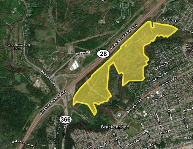
R & Z HARRISON PROPERTIES LP PLAN OF PARCELS PARCEL 3 = 152.55X100.00X410.77X206.00X154.21X55.39X32.18X 132.09X171.92X145.63X137.63X146.99X178.79X111.15X95.33X53.43
Pittsburgh, PA
ALLEGHENY
1367-A-00005-0000-00
Pennsylvania
Commercialacreage
5
2024
109.61 AC
2025
Northeast Pittsburgh
401100
NEARBY LISTINGS FOR SALE OR LEASE
DEMOGRAPHICS near Freeport Rd
1 mile
3 mile
5 mile
2025 Total Population
7,548
35,982
58,994
2030 Population
7,451
35,695
58,622
Pop Growth 2025-2030
(1.29%)
(0.80%)
(0.63%)
Average Age
43
44
45
2025 Total Households
3,388
16,271
26,515
HH Growth 2025-2030
(1.30%)
(0.82%)
(0.65%)
Median Household Inc
$54,091
$62,576
$64,483
Avg Household Size
2.20
2.20
2.20
2025 Avg HH Vehicles
1.00
2.00
2.00
Median Home Value
$114,721
$150,089
$161,245
Median Year Built
1948
1954
1955
Nearby Places
Map Layers
Map Styles
 Street
 Aerial
Layers
 Traffic
 Biking
Places
Listings with unknown addresses are not visible on the map
- Restaurants
- Banks
- Shops
- Fitness
- Groceries
PUBLIC TRANSPORTATION
AIRPORT
Pittsburgh International
Drive
Walk
Distance
Pittsburgh International
58 min
39.8 mi
Arnold Palmer Regional
Drive
Walk
Distance
Arnold Palmer Regional
71 min
47.9 mi
Freight Ports
Port of Baltimore
Drive
Walk
Distance
Port of Baltimore
296 min
253.0 mi
Nearby Properties
Address
Land Use
TOTAL SIZE
Lot Size
Zoning
Address
Land Use
TOTAL SIZE
Lot Size
Zoning
Address
Land Use
TOTAL SIZE
Lot Size
Zoning
Address
Land Use
TOTAL SIZE
Lot Size
Zoning
95.69 AC
Address
Land Use
TOTAL SIZE
Lot Size
Zoning
Address
Land Use
TOTAL SIZE
Lot Size
Zoning
Address
Land Use
TOTAL SIZE
Lot Size
Zoning
1.77 AC
Address
Land Use
TOTAL SIZE
Lot Size
Zoning
35.56 AC
Address
Land Use
TOTAL SIZE
Lot Size
Zoning
Address
Land Use
TOTAL SIZE
Lot Size
Zoning
26.76 AC
Address
Land Use
TOTAL SIZE
Lot Size
Zoning
Address
Land Use
TOTAL SIZE
Lot Size
Zoning
3,248 SF
2.41 AC
Address
Land Use
TOTAL SIZE
Lot Size
Zoning
Address
Land Use
TOTAL SIZE
Lot Size
Zoning
67.50 AC
Address
Land Use
TOTAL SIZE
Lot Size
Zoning
0.79 AC
Address
Land Use
TOTAL SIZE
Lot Size
Zoning
Address
Land Use
TOTAL SIZE
Lot Size
Zoning
Address
Land Use
TOTAL SIZE
Lot Size
Zoning
Address
Land Use
TOTAL SIZE
Lot Size
Zoning
1.54 AC
Address
Land Use
TOTAL SIZE
Lot Size
Zoning
12.11 AC
Address
Land Use
TOTAL SIZE
Lot Size
Zoning
14.92 AC
Address
Land Use
TOTAL SIZE
Lot Size
Zoning
4.25 AC
Address
Land Use
TOTAL SIZE
Lot Size
Zoning
2,528 SF
1.25 AC
Address
Land Use
TOTAL SIZE
Lot Size
Zoning
Address
Land Use
TOTAL SIZE
Lot Size
Zoning
3,253 SF
1.19 AC
Address
Land Use
TOTAL SIZE
Lot Size
Zoning
Address
Land Use
TOTAL SIZE
Lot Size
Zoning
0.21 AC
Address
Land Use
TOTAL SIZE
Lot Size
Zoning
Address
Land Use
TOTAL SIZE
Lot Size
Zoning
0.48 AC
Address
Land Use
TOTAL SIZE
Lot Size
Zoning
2,382 SF
0.80 AC
Address
Land Use
TOTAL SIZE
Lot Size
Zoning
The World's #1 Commercial Real Estate Marketplace
Connect with us
© 2026 CoStar Group
The information above has been obtained from sources believed reliable. While we do not doubt its accuracy we have not verified it and make no guarantee, warranty or representation about it. It is your responsibility to independently confirm its accuracy and completeness. Any projections, opinions, assumptions, or estimates used are for example only and do not represent the current or future performance of the property. The value of this transaction to you depends on tax and other factors which should be evaluated by your tax, financial, and legal advisors. You and your advisors should conduct a careful, independent investigation of the property to determine to your satisfaction the suitability of the property for your needs.