Property Record
Freeway Cir, Middleburg Hts, OH 44130
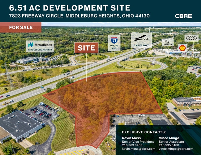
This Property Is For Sale
NEARBY LISTINGS FOR SALE OR LEASE
Property Detail
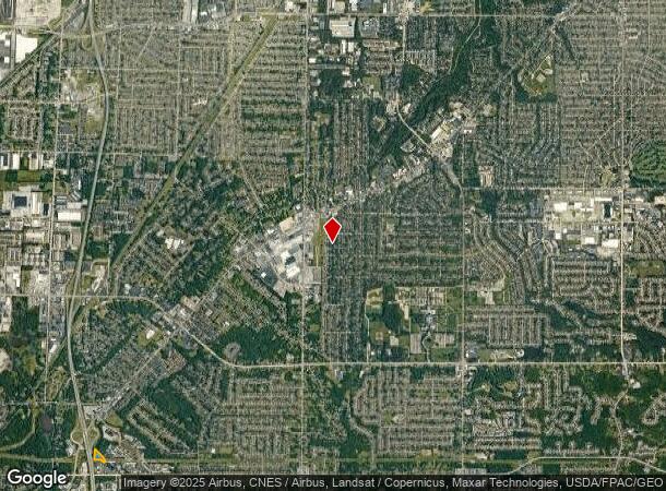
Freeway Cir
Cleveland-Elyria, OH
Baldwin
374-17-008
6 BAGLOFC 0010 ALL
Commercialacreage
Cuyahoga
A
Ohio
39035C0277E
10
2024
2.97 AC
2024
Southwest
178206
Cleveland
DEMOGRAPHICS near Freeway Cir
1 mile
3 mile
5 mile
2024 Total Population
8,666
60,237
156,677
2029 Population
8,451
58,443
152,444
Pop Growth 2024-2029
(2.48%)
(2.98%)
(2.70%)
Average Age
40
44
44
2024 Total Households
3,985
25,916
67,226
HH Growth 2024-2029
(2.89%)
(3.21%)
(2.91%)
Median Household Inc
$69,548
$70,696
$70,588
Avg Household Size
2.10
2.20
2.20
2024 Avg HH Vehicles
2.00
2.00
2.00
Median Home Value
$191,054
$184,455
$186,603
Median Year Built
1971
1967
1969
Nearby Places
Map Layers
Map Styles
 Street
 Aerial
Transit
 Traffic
 Biking
Places
Listings with unknown addresses are not visible on the map
- Restaurants
- Banks
- Shops
- Fitness
- Groceries
PUBLIC TRANSPORTATION
COMMUTER RAIL
Rockside (National Park Scenic Railway - Cuyahoga Valley Scenic Railroad)
Drive
Walk
Distance
Rockside (National Park Scenic Railway - Cuyahoga Valley Scenic Railroad)
21 min
9.4 mi
AIRPORT
Cleveland-Hopkins International
Drive
Walk
Distance
Cleveland-Hopkins International
18 min
7.5 mi
Freight Ports
Port of Toledo
Drive
Walk
Distance
Port of Toledo
133 min
108.8 mi
Nearby Properties
Address
Land Use
TOTAL SIZE
Lot Size
Zoning
Address
Land Use
TOTAL SIZE
Lot Size
Zoning
1,490,538 SF
19.29 AC
PF
Address
Land Use
TOTAL SIZE
Lot Size
Zoning
237,144 SF
2.12 AC
PG
Address
Land Use
TOTAL SIZE
Lot Size
Zoning
668,882 SF
41.27 AC
SC
Address
Land Use
TOTAL SIZE
Lot Size
Zoning
477,641 SF
14.07 AC
MF-1
Address
Land Use
TOTAL SIZE
Lot Size
Zoning
725,585 SF
76.92 AC
SF-A
Address
Land Use
TOTAL SIZE
Lot Size
Zoning
245,255 SF
14 AC
Address
Land Use
TOTAL SIZE
Lot Size
Zoning
768,485 SF
14.53 AC
R1-A
Address
Land Use
TOTAL SIZE
Lot Size
Zoning
168,729 SF
11.56 AC
GB
Address
Land Use
TOTAL SIZE
Lot Size
Zoning
88.28 AC
U5-A
Address
Land Use
TOTAL SIZE
Lot Size
Zoning
505,418 SF
33.99 AC
SC
Address
Land Use
TOTAL SIZE
Lot Size
Zoning
126,000 SF
3.02 AC
PG
Address
Land Use
TOTAL SIZE
Lot Size
Zoning
379,061 SF
42.68 AC
Address
Land Use
TOTAL SIZE
Lot Size
Zoning
632,686 SF
16.44 AC
MF-3
Address
Land Use
TOTAL SIZE
Lot Size
Zoning
33.27 AC
IA
Address
Land Use
TOTAL SIZE
Lot Size
Zoning
355,701 SF
16.35 AC
OB
Address
Land Use
TOTAL SIZE
Lot Size
Zoning
300,120 SF
20.18 AC
GI
Address
Land Use
TOTAL SIZE
Lot Size
Zoning
263,867 SF
59.28 AC
PF
Address
Land Use
TOTAL SIZE
Lot Size
Zoning
132.06 AC
IA
Address
Land Use
TOTAL SIZE
Lot Size
Zoning
107,427 SF
30 AC
SF-A
Address
Land Use
TOTAL SIZE
Lot Size
Zoning
86,081 SF
14.45 AC
B
Address
Land Use
TOTAL SIZE
Lot Size
Zoning
263,926 SF
95.55 AC
GI
Address
Land Use
TOTAL SIZE
Lot Size
Zoning
78,000 SF
5.78 AC
OB
Address
Land Use
TOTAL SIZE
Lot Size
Zoning
111,220 SF
23.65 AC
IA
Address
Land Use
TOTAL SIZE
Lot Size
Zoning
76,288 SF
258.02 AC
PG
Address
Land Use
TOTAL SIZE
Lot Size
Zoning
275,274 SF
16.91 AC
RMF-1
Address
Land Use
TOTAL SIZE
Lot Size
Zoning
245,255 SF
13.34 AC
Address
Land Use
TOTAL SIZE
Lot Size
Zoning
110,648 SF
10.79 AC
SR/LC
Address
Land Use
TOTAL SIZE
Lot Size
Zoning
83,375 SF
9.29 AC
MF-1
Address
Land Use
TOTAL SIZE
Lot Size
Zoning
32,820 SF
3.60 AC
U7-B
Address
Land Use
TOTAL SIZE
Lot Size
Zoning
74,731 SF
15.23 AC
A
The World's #1 Commercial Real Estate Marketplace
Connect with us
© 2026 CoStar Group
The information above has been obtained from sources believed reliable. While we do not doubt its accuracy we have not verified it and make no guarantee, warranty or representation about it. It is your responsibility to independently confirm its accuracy and completeness. Any projections, opinions, assumptions, or estimates used are for example only and do not represent the current or future performance of the property. The value of this transaction to you depends on tax and other factors which should be evaluated by your tax, financial, and legal advisors. You and your advisors should conduct a careful, independent investigation of the property to determine to your satisfaction the suitability of the property for your needs.