Property Record
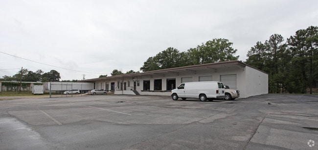
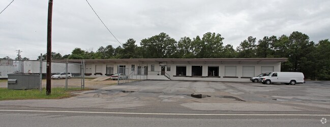
Frink St, Cayce, SC 29033

Property Detail
Frink St
005724-06-004
BROADACRES LOTS 22-29 & PT 21 BLK A
Commercialnec
LEXINGTON
M2
South Carolina
B and X Area of moderate flood hazard, usually the area between the limits of the 100-year and 500-year floods.
22-29
2025
0.79 AC
2024
Cayce/West Columbia
020100
Columbia
11,416 SF
Columbia, SC
NEARBY LISTINGS FOR SALE OR LEASE
DEMOGRAPHICS near Frink St
1 mile
3 mile
5 mile
2025 Total Population
6,256
38,607
108,962
2030 Population
6,515
40,540
114,017
Pop Growth 2025-2030
+ 4.14%
+ 5.01%
+ 4.64%
Average Age
41
38
37
2025 Total Households
2,726
16,954
48,335
HH Growth 2025-2030
+ 4.33%
+ 5.39%
+ 4.97%
Median Household Inc
$51,000
$50,565
$54,546
Avg Household Size
2.20
2.10
2.00
2025 Avg HH Vehicles
2.00
2.00
2.00
Median Home Value
$155,639
$182,371
$222,145
Median Year Built
1967
1971
1977
Nearby Places
Map Layers
Map Styles
 Street
 Aerial
Transit
 Traffic
 Biking
Places
Listings with unknown addresses are not visible on the map
- Restaurants
- Banks
- Shops
- Fitness
- Groceries
PUBLIC TRANSPORTATION
COMMUTER RAIL
Drive
Walk
Distance
9 min
4.6 mi
AIRPORT
Columbia Metro
Drive
Walk
Distance
Columbia Metro
16 min
5.6 mi
Nearby Properties
Address
Land Use
TOTAL SIZE
Lot Size
Zoning
Address
Land Use
TOTAL SIZE
Lot Size
Zoning
311,168 SF
3.98 AC
MC
Address
Land Use
TOTAL SIZE
Lot Size
Zoning
490,633 SF
13.20 AC
RM-2
Address
Land Use
TOTAL SIZE
Lot Size
Zoning
352,672 SF
5.16 AC
MC
Address
Land Use
TOTAL SIZE
Lot Size
Zoning
155,883 SF
2.74 AC
MC
Address
Land Use
TOTAL SIZE
Lot Size
Zoning
22,802 SF
2.64 AC
MC
Address
Land Use
TOTAL SIZE
Lot Size
Zoning
121,560 SF
8.46 AC
RM-2
Address
Land Use
TOTAL SIZE
Lot Size
Zoning
196,800 SF
5.83 AC
HI
Address
Land Use
TOTAL SIZE
Lot Size
Zoning
12.50 AC
PD
Address
Land Use
TOTAL SIZE
Lot Size
Zoning
99,720 SF
3.81 AC
MC
Address
Land Use
TOTAL SIZE
Lot Size
Zoning
152,064 SF
9.58 AC
RM-2
Address
Land Use
TOTAL SIZE
Lot Size
Zoning
158,976 SF
11.28 AC
RM-2
Address
Land Use
TOTAL SIZE
Lot Size
Zoning
686,209 SF
1.73 AC
RM-2
Address
Land Use
TOTAL SIZE
Lot Size
Zoning
237 AC
HI
Address
Land Use
TOTAL SIZE
Lot Size
Zoning
0.46 AC
C-1
Address
Land Use
TOTAL SIZE
Lot Size
Zoning
56,245 SF
2.75 AC
RM-2
Address
Land Use
TOTAL SIZE
Lot Size
Zoning
55,640 SF
2.57 AC
MC
Address
Land Use
TOTAL SIZE
Lot Size
Zoning
75,326 SF
4.89 AC
LI
Address
Land Use
TOTAL SIZE
Lot Size
Zoning
39,172 SF
2.30 AC
RG-2
Address
Land Use
TOTAL SIZE
Lot Size
Zoning
14.88 AC
PD
Address
Land Use
TOTAL SIZE
Lot Size
Zoning
15,350 SF
1.06 AC
RS-3
Address
Land Use
TOTAL SIZE
Lot Size
Zoning
36,490 SF
3.49 AC
EC
Address
Land Use
TOTAL SIZE
Lot Size
Zoning
27,579 SF
1.01 AC
MC
Address
Land Use
TOTAL SIZE
Lot Size
Zoning
87,623 SF
2.12 AC
M-1
Address
Land Use
TOTAL SIZE
Lot Size
Zoning
8,800 SF
0.88 AC
MC
Address
Land Use
TOTAL SIZE
Lot Size
Zoning
3.58 AC
M-2
Address
Land Use
TOTAL SIZE
Lot Size
Zoning
1.77 AC
MC
Address
Land Use
TOTAL SIZE
Lot Size
Zoning
95,854 SF
3.41 AC
M-1
Address
Land Use
TOTAL SIZE
Lot Size
Zoning
126,321 SF
3.17 AC
MC
Address
Land Use
TOTAL SIZE
Lot Size
Zoning
3,614 SF
1,444.32 AC
ID
Address
Land Use
TOTAL SIZE
Lot Size
Zoning
65,340 SF
2.72 AC
M-1
The World's #1 Commercial Real Estate Marketplace
Connect with us
© 2026 CoStar Group
The information above has been obtained from sources believed reliable. While we do not doubt its accuracy we have not verified it and make no guarantee, warranty or representation about it. It is your responsibility to independently confirm its accuracy and completeness. Any projections, opinions, assumptions, or estimates used are for example only and do not represent the current or future performance of the property. The value of this transaction to you depends on tax and other factors which should be evaluated by your tax, financial, and legal advisors. You and your advisors should conduct a careful, independent investigation of the property to determine to your satisfaction the suitability of the property for your needs.