Property Record
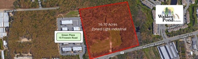
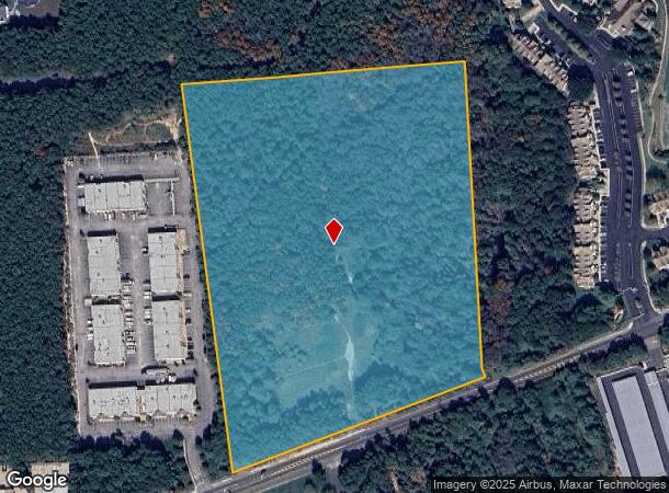
Frowein Rd, East Moriches, NY 11940
NEARBY LISTINGS FOR SALE OR LEASE
Property Detail
Frowein Rd
Nassau County-Suffolk County, NY
East Moriches
0200-793-00-01-00-021-000
N CAYUGA ST E BERNSTEIN S FROWEIN R
Residentialacreage
Suffolk
X
New York
36103C0742H
21
2024
16.10 AC
2024
Eastern Suffolk
159406
Long Island (New York)
DEMOGRAPHICS near Frowein Rd
1 Mile
3 Mile
5 Mile
2024 Total Population
4,264
27,289
67,885
2029 Population
4,237
27,164
67,403
Pop Growth 2024-2029
(0.63%)
(0.46%)
(0.71%)
Average Age
41
43
41
2024 Total Households
1,394
9,951
22,979
HH Growth 2024-2029
(0.79%)
(0.57%)
(0.83%)
Median Household Inc
$102,573
$109,322
$105,885
Avg Household Size
2.80
2.70
2.80
2024 Avg HH Vehicles
2.00
2.00
2.00
Median Home Value
$642,570
$541,301
$435,239
Median Year Built
1989
1986
1979
Nearby Places
- Restaurants
- Banks
- Shops
- Fitness
- Groceries
PUBLIC TRANSPORTATION
COMMUTER RAIL
Speonk Station (Montauk Branch - Long Island Rail Road)
DRIVE
WALK
Distance
Speonk Station (Montauk Branch - Long Island Rail Road)
8 min
4.7 mi
Mastic-Shirley Station (Montauk Branch - Long Island Rail Road)
DRIVE
WALK
Distance
Mastic-Shirley Station (Montauk Branch - Long Island Rail Road)
10 min
5.1 mi
AIRPORT
Long Island MacArthur
DRIVE
WALK
Distance
Long Island MacArthur
31 min
19.5 mi
Freight Ports
Port of New Haven
DRIVE
WALK
Distance
Port of New Haven
147 min
59.3 mi
SALE & LEASE HISTORY
LISTING DATE
SALE/LEASE

Mar 31, 2025
For Sale
Mar 20, 2025
For Sale
Nearby Properties
Address
Land Use
TOTAL SIZE
Lot Size
Zoning
Address
Land Use
TOTAL SIZE
Lot Size
Zoning
87,569 SF
19 AC
R120
Address
Land Use
TOTAL SIZE
Lot Size
Zoning
9,069 SF
4.19 AC
R60
Address
Land Use
TOTAL SIZE
Lot Size
Zoning
1,984 SF
6.19 AC
R60
Address
Land Use
TOTAL SIZE
Lot Size
Zoning
150 SF
4.70 AC
RWB
Address
Land Use
TOTAL SIZE
Lot Size
Zoning
1.60 AC
R60
Address
Land Use
TOTAL SIZE
Lot Size
Zoning
9,256 SF
0.90 AC
R40
Address
Land Use
TOTAL SIZE
Lot Size
Zoning
1.30 AC
R60
Address
Land Use
TOTAL SIZE
Lot Size
Zoning
2.53 AC
R60
Address
Land Use
TOTAL SIZE
Lot Size
Zoning
4,820 SF
2.15 AC
R40
Address
Land Use
TOTAL SIZE
Lot Size
Zoning
2.99 AC
R60
Address
Land Use
TOTAL SIZE
Lot Size
Zoning
2.54 AC
R60
Address
Land Use
TOTAL SIZE
Lot Size
Zoning
1.86 AC
R60
Address
Land Use
TOTAL SIZE
Lot Size
Zoning
18.10 AC
H2O
Address
Land Use
TOTAL SIZE
Lot Size
Zoning
2,509 SF
1 AC
RWB
Address
Land Use
TOTAL SIZE
Lot Size
Zoning
1.64 AC
R60
Address
Land Use
TOTAL SIZE
Lot Size
Zoning
1.40 AC
R60
Address
Land Use
TOTAL SIZE
Lot Size
Zoning
0.92 AC
R60
Address
Land Use
TOTAL SIZE
Lot Size
Zoning
3,734 SF
1.06 AC
HO
Address
Land Use
TOTAL SIZE
Lot Size
Zoning
0.77 AC
R60
Address
Land Use
TOTAL SIZE
Lot Size
Zoning
5,096 SF
1.53 AC
R40
Address
Land Use
TOTAL SIZE
Lot Size
Zoning
3,480 SF
0.48 AC
R20
Address
Land Use
TOTAL SIZE
Lot Size
Zoning
Address
Land Use
TOTAL SIZE
Lot Size
Zoning
2,948 SF
7.17 AC
R40
Address
Land Use
TOTAL SIZE
Lot Size
Zoning
1,280 SF
5.99 AC
R40
Address
Land Use
TOTAL SIZE
Lot Size
Zoning
2.60 AC
Address
Land Use
TOTAL SIZE
Lot Size
Zoning
2.18 AC
R40
Address
Land Use
TOTAL SIZE
Lot Size
Zoning
0.96 AC
R40
Address
Land Use
TOTAL SIZE
Lot Size
Zoning
1.74 AC
R40
Address
Land Use
TOTAL SIZE
Lot Size
Zoning
1.64 AC
R40
Address
Land Use
TOTAL SIZE
Lot Size
Zoning
6,114 SF
0.35 AC
R20
The World's #1 Commercial Real Estate Marketplace
Connect with us
© 2025 CoStar Group
The information above has been obtained from sources believed reliable. While we do not doubt its accuracy we have not verified it and make no guarantee, warranty or representation about it. It is your responsibility to independently confirm its accuracy and completeness. Any projections, opinions, assumptions, or estimates used are for example only and do not represent the current or future performance of the property. The value of this transaction to you depends on tax and other factors which should be evaluated by your tax, financial, and legal advisors. You and your advisors should conduct a careful, independent investigation of the property to determine to your satisfaction the suitability of the property for your needs.