Property Record
Fulford Rd, Waycross, GA 31503

Current Lease Availabilities
NEARBY LISTINGS FOR SALE OR LEASE
Property Detail
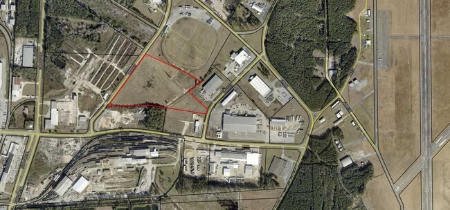
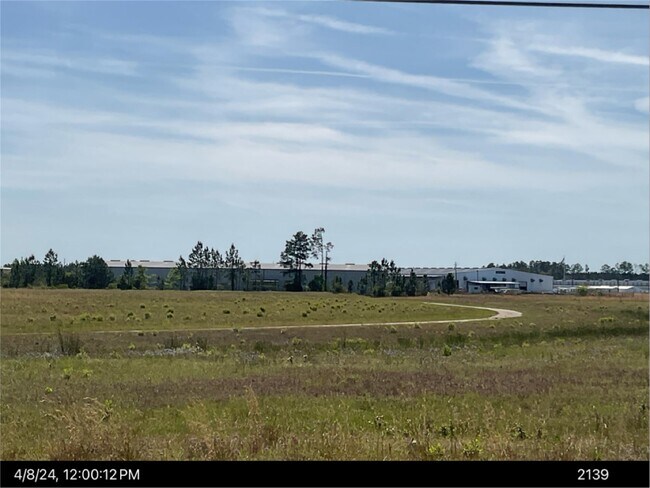
Fulford Rd
050-04-011
FULFORD RD LL106 &107 & 124/8
Governmentalpublicusegeneral
Ware
X
Georgia
13299C0235D
18.98 AC
0
Georgia South Area
2025
Other Market Areas
950400
Waycross, GA
DEMOGRAPHICS near Fulford Rd
1 Mile
3 Mile
5 Mile
2024 Total Population
124
7,901
25,991
2029 Population
121
7,676
26,005
Pop Growth 2024-2029
(2.42%)
(2.85%)
+ 0.05%
Average Age
44
41
40
2024 Total Households
42
2,764
9,580
HH Growth 2024-2029
(2.38%)
(2.42%)
+ 0.19%
Median Household Inc
$62,812
$44,007
$36,989
Avg Household Size
2.60
2.40
2.50
2024 Avg HH Vehicles
2.00
2.00
2.00
Median Home Value
$97,058
$117,332
$87,264
Median Year Built
1989
1980
1974
Nearby Places
Map Layers
Map Styles
 Street
 Aerial
- Restaurants
- Banks
- Shops
- Fitness
- Groceries
Nearby Properties
Address
Land Use
TOTAL SIZE
Lot Size
Zoning
Address
Land Use
TOTAL SIZE
Lot Size
Zoning
56.91 AC
005
Address
Land Use
TOTAL SIZE
Lot Size
Zoning
57,875 SF
59 AC
003
Address
Land Use
TOTAL SIZE
Lot Size
Zoning
77,096 SF
32.52 AC
002
Address
Land Use
TOTAL SIZE
Lot Size
Zoning
91,611 SF
76.30 AC
006
Address
Land Use
TOTAL SIZE
Lot Size
Zoning
3,264 SF
864.77 AC
006
Address
Land Use
TOTAL SIZE
Lot Size
Zoning
217,500 SF
42.32 AC
001
Address
Land Use
TOTAL SIZE
Lot Size
Zoning
46,296 SF
16 AC
006
Address
Land Use
TOTAL SIZE
Lot Size
Zoning
139,200 SF
24.09 AC
Address
Land Use
TOTAL SIZE
Lot Size
Zoning
100,000 SF
18.67 AC
003
Address
Land Use
TOTAL SIZE
Lot Size
Zoning
177,845 SF
66.23 AC
003
Address
Land Use
TOTAL SIZE
Lot Size
Zoning
12,417 SF
10.69 AC
001
Address
Land Use
TOTAL SIZE
Lot Size
Zoning
40,016 SF
15.54 AC
006
Address
Land Use
TOTAL SIZE
Lot Size
Zoning
102,071 SF
20 AC
006
Address
Land Use
TOTAL SIZE
Lot Size
Zoning
12,747 SF
5.65 AC
006
Address
Land Use
TOTAL SIZE
Lot Size
Zoning
126,720 SF
14.99 AC
003
Address
Land Use
TOTAL SIZE
Lot Size
Zoning
37,245 SF
32.58 AC
009
Address
Land Use
TOTAL SIZE
Lot Size
Zoning
70,320 SF
26.37 AC
004
Address
Land Use
TOTAL SIZE
Lot Size
Zoning
71,172 SF
15.02 AC
003
Address
Land Use
TOTAL SIZE
Lot Size
Zoning
56 AC
006
Address
Land Use
TOTAL SIZE
Lot Size
Zoning
25,484 SF
314.65 AC
006
Address
Land Use
TOTAL SIZE
Lot Size
Zoning
23,775 SF
5.91 AC
003
Address
Land Use
TOTAL SIZE
Lot Size
Zoning
9,548 SF
3.30 AC
006
Address
Land Use
TOTAL SIZE
Lot Size
Zoning
76,073 SF
7.04 AC
005
Address
Land Use
TOTAL SIZE
Lot Size
Zoning
6,660 SF
1.37 AC
004
Address
Land Use
TOTAL SIZE
Lot Size
Zoning
123,626 SF
15.86 AC
003
Address
Land Use
TOTAL SIZE
Lot Size
Zoning
3,007 SF
10.61 AC
002
Address
Land Use
TOTAL SIZE
Lot Size
Zoning
4,164 SF
7.13 AC
006
Address
Land Use
TOTAL SIZE
Lot Size
Zoning
12,838 SF
7.30 AC
001
Address
Land Use
TOTAL SIZE
Lot Size
Zoning
61,881 SF
6.04 AC
003
Address
Land Use
TOTAL SIZE
Lot Size
Zoning
7,397 SF
19.36 AC
006
The World's #1 Commercial Real Estate Marketplace
Connect with us
© 2026 CoStar Group
The information above has been obtained from sources believed reliable. While we do not doubt its accuracy we have not verified it and make no guarantee, warranty or representation about it. It is your responsibility to independently confirm its accuracy and completeness. Any projections, opinions, assumptions, or estimates used are for example only and do not represent the current or future performance of the property. The value of this transaction to you depends on tax and other factors which should be evaluated by your tax, financial, and legal advisors. You and your advisors should conduct a careful, independent investigation of the property to determine to your satisfaction the suitability of the property for your needs.