Property Record
Garcia Ranch Rd, Briones, CA 94553


Save to a Folder
{{folder.Name}}
{{folder.ListingIds.length}} Properties
{{folder.ListingIds.length}} Property
Create a New Folder
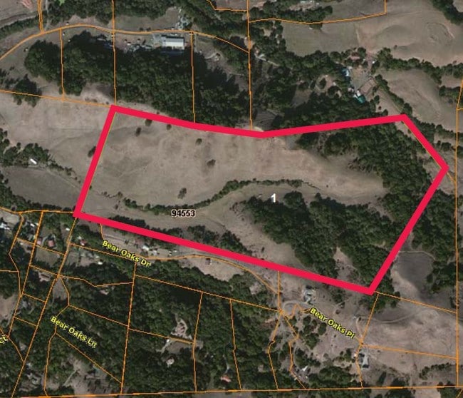
Property Detail
Garcia Ranch Rd
Oakland-Fremont-Berkeley, CA
GARCIA RANCH POR LOT 12
365-030-058-9
CONTRA COSTA
Pasture
California
A2
12
B and X Area of moderate flood hazard, usually the area between the limits of the 100-year and 500-year floods.
106.09 AC
2025
Martinez/Pacheco/Hercules
2026
East Bay/Oakland
321101
NEARBY LISTINGS FOR SALE OR LEASE
-
-
View all Briones listings for sale on LoopNet.com
DEMOGRAPHICS near Garcia Ranch Rd
1 mile
3 mile
5 mile
2025 Total Population
76
3,699
60,543
2030 Population
75
3,721
60,944
Pop Growth 2025-2030
(1.32%)
+ 0.59%
+ 0.66%
Average Age
47
45
45
2025 Total Households
28
1,292
23,420
HH Growth 2025-2030
0.00%
+ 0.54%
+ 0.68%
Median Household Inc
$183,333
$258,242
$181,692
Avg Household Size
2.70
2.80
2.60
2025 Avg HH Vehicles
3.00
2.00
2.00
Median Home Value
$1,023,077
$1,125,444
$1,075,872
Median Year Built
1983
1965
1971
Nearby Places
Map Layers
Map Styles
 Street
 Aerial
Layers
 Traffic
 Biking
Places
Listings with unknown addresses are not visible on the map
- Restaurants
- Banks
- Shops
- Fitness
- Groceries
PUBLIC TRANSPORTATION
AIRPORT
Metro Oakland International
Drive
Walk
Distance
Metro Oakland International
40 min
24.9 mi
San Francisco International
Drive
Walk
Distance
San Francisco International
58 min
36.9 mi
Freight Ports
Port of Richmond
Drive
Walk
Distance
Port of Richmond
39 min
20.1 mi
Nearby Properties
Address
Land Use
TOTAL SIZE
Lot Size
Zoning
Address
Land Use
TOTAL SIZE
Lot Size
Zoning
8,893 SF
13.16 AC
Address
Land Use
TOTAL SIZE
Lot Size
Zoning
2,920 SF
83.18 AC
A2
Address
Land Use
TOTAL SIZE
Lot Size
Zoning
4,948 SF
10.54 AC
Address
Land Use
TOTAL SIZE
Lot Size
Zoning
221.66 AC
A2
Address
Land Use
TOTAL SIZE
Lot Size
Zoning
728 SF
138.81 AC
A2
Address
Land Use
TOTAL SIZE
Lot Size
Zoning
2,985 SF
21 AC
A20
Address
Land Use
TOTAL SIZE
Lot Size
Zoning
23.29 AC
A2
Address
Land Use
TOTAL SIZE
Lot Size
Zoning
3,812 SF
19.05 AC
Address
Land Use
TOTAL SIZE
Lot Size
Zoning
269.50 AC
A2
Address
Land Use
TOTAL SIZE
Lot Size
Zoning
5,132 SF
25.21 AC
A2
Address
Land Use
TOTAL SIZE
Lot Size
Zoning
5,443 SF
12.78 AC
A2
Address
Land Use
TOTAL SIZE
Lot Size
Zoning
5,349 SF
45.16 AC
A2
Address
Land Use
TOTAL SIZE
Lot Size
Zoning
3,438 SF
16.54 AC
A2
Address
Land Use
TOTAL SIZE
Lot Size
Zoning
16.75 AC
Address
Land Use
TOTAL SIZE
Lot Size
Zoning
214.86 AC
A2
Address
Land Use
TOTAL SIZE
Lot Size
Zoning
3,039 SF
1 AC
R40
Address
Land Use
TOTAL SIZE
Lot Size
Zoning
0.58 AC
Address
Land Use
TOTAL SIZE
Lot Size
Zoning
134.30 AC
Address
Land Use
TOTAL SIZE
Lot Size
Zoning
4,100 SF
35.62 AC
A2
Address
Land Use
TOTAL SIZE
Lot Size
Zoning
4,700 SF
25.56 AC
A2
Address
Land Use
TOTAL SIZE
Lot Size
Zoning
1,392 SF
160.45 AC
A4
Address
Land Use
TOTAL SIZE
Lot Size
Zoning
4,619 SF
12.60 AC
A2
Address
Land Use
TOTAL SIZE
Lot Size
Zoning
61.17 AC
A2
Address
Land Use
TOTAL SIZE
Lot Size
Zoning
105.92 AC
Address
Land Use
TOTAL SIZE
Lot Size
Zoning
2.74 AC
Address
Land Use
TOTAL SIZE
Lot Size
Zoning
1,848 SF
42.87 AC
A2
Address
Land Use
TOTAL SIZE
Lot Size
Zoning
4,289 SF
2.52 AC
Address
Land Use
TOTAL SIZE
Lot Size
Zoning
3,442 SF
11.29 AC
A2
Address
Land Use
TOTAL SIZE
Lot Size
Zoning
2,117 SF
20.89 AC
A20
Address
Land Use
TOTAL SIZE
Lot Size
Zoning
22.70 AC
A2
The World's #1 Commercial Real Estate Marketplace
Connect with us
© 2026 CoStar Group
The information above has been obtained from sources believed reliable. While we do not doubt its accuracy we have not verified it and make no guarantee, warranty or representation about it. It is your responsibility to independently confirm its accuracy and completeness. Any projections, opinions, assumptions, or estimates used are for example only and do not represent the current or future performance of the property. The value of this transaction to you depends on tax and other factors which should be evaluated by your tax, financial, and legal advisors. You and your advisors should conduct a careful, independent investigation of the property to determine to your satisfaction the suitability of the property for your needs.