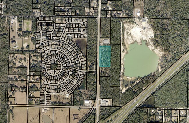
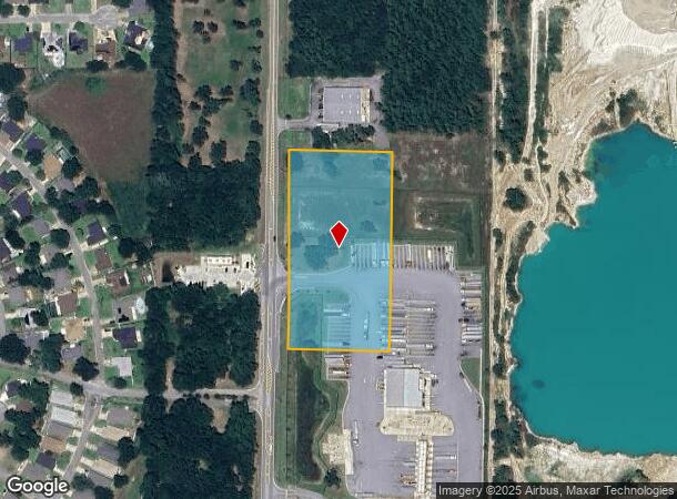
Property Record
Garcon Point Rd, Milton, FL 32583
NEARBY LISTINGS FOR SALE OR LEASE
Property Detail
Garcon Point Rd
Pensacola-Ferry Pass-Brent, FL
*NEW DESC FOR 2020 TAX ROLL* COMMENCE AT A REBAR FOUND AT THE NORTHEAST CORNER OF THE WEST HALF OF SAID GOVERNMENT LOT 4; THENCE RUN NORTH 87 DEGREES, 47 MINUTES, 22 SECONDS WEST, 305.09 FEET TO A CAPPED REBAR FOUND (NWFLS); THENCE NORTH 87 DEGREES 4
23-1N-28-0000-01307-0000
Santa Rosa
Commercialacreage
Florida
X
4
12113C0435H
4.20 AC
2024
Avalon Beach/Milton
2025
Pensacola
010709
DEMOGRAPHICS near Garcon Point Rd
1 Mile
3 Mile
5 Mile
2024 Total Population
1,569
9,387
35,933
2029 Population
1,805
10,861
41,425
Pop Growth 2024-2029
+ 15.04%
+ 15.70%
+ 15.28%
Average Age
42
41
41
2024 Total Households
608
3,674
13,965
HH Growth 2024-2029
+ 15.46%
+ 16.03%
+ 15.63%
Median Household Inc
$71,726
$71,433
$72,242
Avg Household Size
2.50
2.50
2.50
2024 Avg HH Vehicles
2.00
2.00
2.00
Median Home Value
$250,408
$215,381
$213,034
Median Year Built
2001
1995
1991
Nearby Places
Map Layers
Map Styles
 Street
 Aerial
- Restaurants
- Banks
- Shops
- Fitness
- Groceries
PUBLIC TRANSPORTATION
AIRPORT
Pensacola International
DRIVE
WALK
Distance
Pensacola International
26 min
16.8 mi
Freight Ports
Port of Mobile
DRIVE
WALK
Distance
Port of Mobile
75 min
66.9 mi
Nearby Properties
Address
Land Use
TOTAL SIZE
Lot Size
Zoning
Address
Land Use
TOTAL SIZE
Lot Size
Zoning
113,178 SF
8.61 AC
HCD
Address
Land Use
TOTAL SIZE
Lot Size
Zoning
82,878 SF
9.07 AC
HCD
Address
Land Use
TOTAL SIZE
Lot Size
Zoning
98,250 SF
49.63 AC
HCD
Address
Land Use
TOTAL SIZE
Lot Size
Zoning
60,717 SF
4.43 AC
HCD
Address
Land Use
TOTAL SIZE
Lot Size
Zoning
26,200 SF
7.74 AC
HCD
Address
Land Use
TOTAL SIZE
Lot Size
Zoning
77,589 SF
9.39 AC
HCD
Address
Land Use
TOTAL SIZE
Lot Size
Zoning
4.33 AC
HR1
Address
Land Use
TOTAL SIZE
Lot Size
Zoning
9,058 SF
8.35 AC
I1
Address
Land Use
TOTAL SIZE
Lot Size
Zoning
42,160 SF
7.90 AC
HCD
Address
Land Use
TOTAL SIZE
Lot Size
Zoning
16,009 SF
8.69 AC
HCD
Address
Land Use
TOTAL SIZE
Lot Size
Zoning
48,158 SF
4.72 AC
HCD
Address
Land Use
TOTAL SIZE
Lot Size
Zoning
14,800 SF
44.73 AC
M1
Address
Land Use
TOTAL SIZE
Lot Size
Zoning
930 SF
118.07 AC
M2
Address
Land Use
TOTAL SIZE
Lot Size
Zoning
6,276 SF
1.71 AC
HCD
Address
Land Use
TOTAL SIZE
Lot Size
Zoning
46,475 SF
3.06 AC
M1
Address
Land Use
TOTAL SIZE
Lot Size
Zoning
16,054 SF
6 AC
HCD
Address
Land Use
TOTAL SIZE
Lot Size
Zoning
16,510 SF
6.09 AC
HCD
Address
Land Use
TOTAL SIZE
Lot Size
Zoning
22,259 SF
45.80 AC
M2
Address
Land Use
TOTAL SIZE
Lot Size
Zoning
7,968 SF
1.19 AC
HCD
Address
Land Use
TOTAL SIZE
Lot Size
Zoning
4,985 SF
20 AC
HCD
Address
Land Use
TOTAL SIZE
Lot Size
Zoning
18,500 SF
83.10 AC
M1
Address
Land Use
TOTAL SIZE
Lot Size
Zoning
29,719 SF
37.22 AC
M2
Address
Land Use
TOTAL SIZE
Lot Size
Zoning
14,501 SF
4.32 AC
HCD
Address
Land Use
TOTAL SIZE
Lot Size
Zoning
9,171 SF
3.20 AC
HCD
Address
Land Use
TOTAL SIZE
Lot Size
Zoning
10,216 SF
2.36 AC
HCD
Address
Land Use
TOTAL SIZE
Lot Size
Zoning
12,000 SF
1.75 AC
HCD
Address
Land Use
TOTAL SIZE
Lot Size
Zoning
22,968 SF
10.79 AC
HCD
Address
Land Use
TOTAL SIZE
Lot Size
Zoning
5,181 SF
55.05 AC
M2
Address
Land Use
TOTAL SIZE
Lot Size
Zoning
20,314 SF
2.30 AC
HR1
Address
Land Use
TOTAL SIZE
Lot Size
Zoning
13,159 SF
10.45 AC
HCD
The World's #1 Commercial Real Estate Marketplace
Connect with us
© 2025 CoStar Group
The information above has been obtained from sources believed reliable. While we do not doubt its accuracy we have not verified it and make no guarantee, warranty or representation about it. It is your responsibility to independently confirm its accuracy and completeness. Any projections, opinions, assumptions, or estimates used are for example only and do not represent the current or future performance of the property. The value of this transaction to you depends on tax and other factors which should be evaluated by your tax, financial, and legal advisors. You and your advisors should conduct a careful, independent investigation of the property to determine to your satisfaction the suitability of the property for your needs.