Property Record
Gardenia Blvd, Aubrey, TX 76227
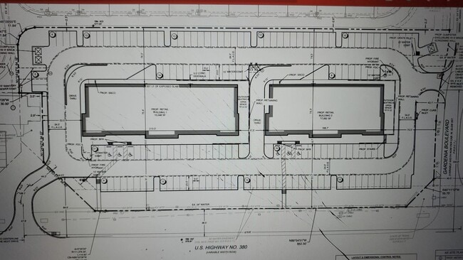


Property Detail
Gardenia Blvd
Dallas/Ft Worth
GARDENIA AND 380 ADDITION BLK A LOT 1
Dallas-Fort Worth-Arlington, TX
DENTON
R992839
Texas
Commercialacreage
1
2024
3.14 AC
2025
Outlying Denton County
020116
NEARBY LISTINGS FOR SALE OR LEASE
DEMOGRAPHICS near Gardenia Blvd
1 mile
3 mile
5 mile
2024 Total Population
15,256
90,816
201,454
2029 Population
17,418
104,358
231,212
Pop Growth 2024-2029
+ 14.17%
+ 14.91%
+ 14.77%
Average Age
36
35
35
2024 Total Households
5,123
28,822
64,616
HH Growth 2024-2029
+ 14.39%
+ 15.33%
+ 15.23%
Median Household Inc
$128,676
$137,286
$134,250
Avg Household Size
2.90
3.10
3.10
2024 Avg HH Vehicles
2.00
2.00
2.00
Median Home Value
$423,522
$462,189
$480,131
Median Year Built
2011
2011
2010
Nearby Places
Map Layers
Map Styles
 Street
 Aerial
Transit
 Traffic
 Biking
Places
Listings with unknown addresses are not visible on the map
- Restaurants
- Banks
- Shops
- Fitness
- Groceries
PUBLIC TRANSPORTATION
AIRPORT
Dallas-Fort Worth International
Drive
Walk
Distance
Dallas-Fort Worth International
40 min
29.8 mi
Dallas Love Field
Drive
Walk
Distance
Dallas Love Field
45 min
35.5 mi
Freight Ports
Port of Shreveport
Drive
Walk
Distance
Port of Shreveport
248 min
228.9 mi
SALE & LEASE HISTORY
LISTING DATE
SALE/LEASE

Sep 24, 2016
For Sale
Sep 23, 2020
For Sale
Oct 06, 2022
For Sale
Nearby Properties
Address
Land Use
TOTAL SIZE
Lot Size
Zoning
Address
Land Use
TOTAL SIZE
Lot Size
Zoning
64,912 SF
582.50 AC
Address
Land Use
TOTAL SIZE
Lot Size
Zoning
389,694 SF
62.34 AC
Address
Land Use
TOTAL SIZE
Lot Size
Zoning
408,166 SF
107.40 AC
Address
Land Use
TOTAL SIZE
Lot Size
Zoning
350,452 SF
55.65 AC
Address
Land Use
TOTAL SIZE
Lot Size
Zoning
308,444 SF
23.65 AC
Address
Land Use
TOTAL SIZE
Lot Size
Zoning
444,118 SF
63.66 AC
Address
Land Use
TOTAL SIZE
Lot Size
Zoning
160,000 SF
19.19 AC
Address
Land Use
TOTAL SIZE
Lot Size
Zoning
382,797 SF
15.82 AC
Address
Land Use
TOTAL SIZE
Lot Size
Zoning
406,229 SF
7.50 AC
Address
Land Use
TOTAL SIZE
Lot Size
Zoning
352,808 SF
25.05 AC
Address
Land Use
TOTAL SIZE
Lot Size
Zoning
352,554 SF
30.67 AC
Address
Land Use
TOTAL SIZE
Lot Size
Zoning
279,504 SF
15.95 AC
Address
Land Use
TOTAL SIZE
Lot Size
Zoning
336,240 SF
17.48 AC
Address
Land Use
TOTAL SIZE
Lot Size
Zoning
234,088 SF
6.60 AC
Address
Land Use
TOTAL SIZE
Lot Size
Zoning
298,501 SF
16.14 AC
Address
Land Use
TOTAL SIZE
Lot Size
Zoning
178,871 SF
49.90 AC
Address
Land Use
TOTAL SIZE
Lot Size
Zoning
308,107 SF
12.97 AC
Address
Land Use
TOTAL SIZE
Lot Size
Zoning
83,470 SF
11.52 AC
Address
Land Use
TOTAL SIZE
Lot Size
Zoning
87,099 SF
15.80 AC
Address
Land Use
TOTAL SIZE
Lot Size
Zoning
73,064 SF
22.66 AC
Address
Land Use
TOTAL SIZE
Lot Size
Zoning
115,100 SF
22.76 AC
Address
Land Use
TOTAL SIZE
Lot Size
Zoning
118,389 SF
30 AC
Address
Land Use
TOTAL SIZE
Lot Size
Zoning
318,000 SF
50.45 AC
Address
Land Use
TOTAL SIZE
Lot Size
Zoning
87,553 SF
14.96 AC
Address
Land Use
TOTAL SIZE
Lot Size
Zoning
106,615 SF
6.18 AC
Address
Land Use
TOTAL SIZE
Lot Size
Zoning
83,332 SF
8.92 AC
Address
Land Use
TOTAL SIZE
Lot Size
Zoning
121,378 SF
19.10 AC
Address
Land Use
TOTAL SIZE
Lot Size
Zoning
81,181 SF
12.52 AC
Address
Land Use
TOTAL SIZE
Lot Size
Zoning
260,520 SF
21.61 AC
Address
Land Use
TOTAL SIZE
Lot Size
Zoning
The World's #1 Commercial Real Estate Marketplace
Connect with us
© 2026 CoStar Group
The information above has been obtained from sources believed reliable. While we do not doubt its accuracy we have not verified it and make no guarantee, warranty or representation about it. It is your responsibility to independently confirm its accuracy and completeness. Any projections, opinions, assumptions, or estimates used are for example only and do not represent the current or future performance of the property. The value of this transaction to you depends on tax and other factors which should be evaluated by your tax, financial, and legal advisors. You and your advisors should conduct a careful, independent investigation of the property to determine to your satisfaction the suitability of the property for your needs.