Property Record
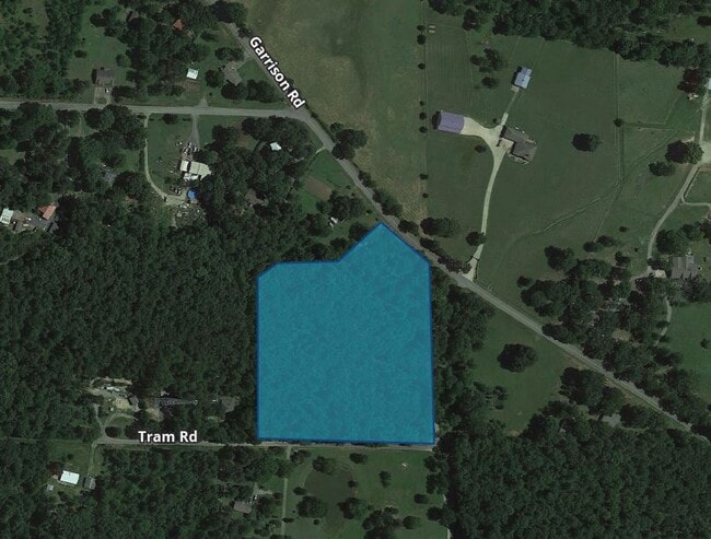
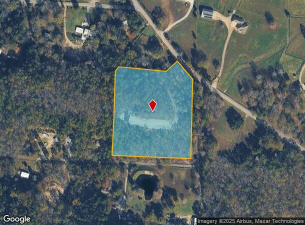
Garrison Rd, Little Rock, AR 72223
NEARBY LISTINGS FOR SALE OR LEASE
-
-
View all Little Rock listings for sale on LoopNet.com
Property Detail
Garrison Rd
63R-023-00-006-06
PT SW NE BEG SE COR TH N86*2231 W509 32 N0*2715E569 21 N33*3319E34 2 S86*55E311 75 N56*18E101 TO WLY R/W GARRISON RD TH S45*2041E156 S0*1619W531 TO POB 23-2N-15W
Residentialacreage
Pulaski
AE
Arkansas
05119C0290G
7.33 AC
2025
Outlying Pulaski County
2025
Little Rock/N Little Rock
004229
Little Rock-North Little Rock-Conway, AR
DEMOGRAPHICS near Garrison Rd
1 Mile
3 Mile
5 Mile
2024 Total Population
352
2,129
8,048
2029 Population
346
2,115
8,214
Pop Growth 2024-2029
(1.70%)
(0.66%)
+ 2.06%
Average Age
46
46
43
2024 Total Households
143
868
3,211
HH Growth 2024-2029
(1.40%)
(0.69%)
+ 1.93%
Median Household Inc
$131,250
$125,858
$115,607
Avg Household Size
2.40
2.40
2.50
2024 Avg HH Vehicles
3.00
3.00
2.00
Median Home Value
$438,889
$421,642
$385,713
Median Year Built
1991
1992
2001
Nearby Places
Map Layers
Map Styles
 Street
 Aerial
- Restaurants
- Banks
- Shops
- Fitness
- Groceries
PUBLIC TRANSPORTATION
AIRPORT
Bill and Hillary Clinton Ntl/Adams Field
DRIVE
WALK
Distance
Bill and Hillary Clinton Ntl/Adams Field
43 min
23.2 mi
Freight Ports
Port of Shreveport
DRIVE
WALK
Distance
Port of Shreveport
265 min
229.1 mi
SALE & LEASE HISTORY
LISTING DATE
SALE/LEASE

Oct 04, 2021
For Sale
Nearby Properties
Address
Land Use
TOTAL SIZE
Lot Size
Zoning
Address
Land Use
TOTAL SIZE
Lot Size
Zoning
32,051 SF
245.44 AC
Address
Land Use
TOTAL SIZE
Lot Size
Zoning
12,113 SF
5.28 AC
Address
Land Use
TOTAL SIZE
Lot Size
Zoning
15,698 SF
82 AC
Address
Land Use
TOTAL SIZE
Lot Size
Zoning
9,596 SF
418.88 AC
Address
Land Use
TOTAL SIZE
Lot Size
Zoning
12,412 SF
1.22 AC
Address
Land Use
TOTAL SIZE
Lot Size
Zoning
1,840 SF
2.79 AC
Address
Land Use
TOTAL SIZE
Lot Size
Zoning
9,220 SF
1.87 AC
Address
Land Use
TOTAL SIZE
Lot Size
Zoning
2,960 SF
0.98 AC
Address
Land Use
TOTAL SIZE
Lot Size
Zoning
4,000 SF
1.39 AC
Address
Land Use
TOTAL SIZE
Lot Size
Zoning
4,860 SF
19.85 AC
Address
Land Use
TOTAL SIZE
Lot Size
Zoning
4,500 SF
3.13 AC
Address
Land Use
TOTAL SIZE
Lot Size
Zoning
6,759 SF
4.10 AC
Address
Land Use
TOTAL SIZE
Lot Size
Zoning
Address
Land Use
TOTAL SIZE
Lot Size
Zoning
2,340 SF
1.07 AC
Address
Land Use
TOTAL SIZE
Lot Size
Zoning
6,500 SF
7.22 AC
Address
Land Use
TOTAL SIZE
Lot Size
Zoning
12,600 SF
1.03 AC
Address
Land Use
TOTAL SIZE
Lot Size
Zoning
2,143 SF
34.95 AC
Address
Land Use
TOTAL SIZE
Lot Size
Zoning
1,855 SF
0.82 AC
Address
Land Use
TOTAL SIZE
Lot Size
Zoning
6,174 SF
0.89 AC
Address
Land Use
TOTAL SIZE
Lot Size
Zoning
7.65 AC
Address
Land Use
TOTAL SIZE
Lot Size
Zoning
928 SF
10.87 AC
Address
Land Use
TOTAL SIZE
Lot Size
Zoning
8.50 AC
Address
Land Use
TOTAL SIZE
Lot Size
Zoning
Address
Land Use
TOTAL SIZE
Lot Size
Zoning
2,089 SF
3.98 AC
Address
Land Use
TOTAL SIZE
Lot Size
Zoning
2,051 SF
0.82 AC
Address
Land Use
TOTAL SIZE
Lot Size
Zoning
Address
Land Use
TOTAL SIZE
Lot Size
Zoning
5,187 SF
0.86 AC
Address
Land Use
TOTAL SIZE
Lot Size
Zoning
Address
Land Use
TOTAL SIZE
Lot Size
Zoning
7.07 AC
Address
Land Use
TOTAL SIZE
Lot Size
Zoning
8,000 SF
4.80 AC
The World's #1 Commercial Real Estate Marketplace
Connect with us
© 2026 CoStar Group
The information above has been obtained from sources believed reliable. While we do not doubt its accuracy we have not verified it and make no guarantee, warranty or representation about it. It is your responsibility to independently confirm its accuracy and completeness. Any projections, opinions, assumptions, or estimates used are for example only and do not represent the current or future performance of the property. The value of this transaction to you depends on tax and other factors which should be evaluated by your tax, financial, and legal advisors. You and your advisors should conduct a careful, independent investigation of the property to determine to your satisfaction the suitability of the property for your needs.